File:Gottlieb Schumacher, Karte des Ostjordanlandes 07-jerash-b--5 (FL13720796 2367037).jpg
קפיצה לניווט
קפיצה לחיפוש

גודל התצוגה המקדימה הזאת: 549 × 599 פיקסלים. רזולוציות אחרות: 220 × 240 פיקסלים | 440 × 480 פיקסלים | 704 × 768 פיקסלים | 938 × 1,024 פיקסלים | 1,877 × 2,048 פיקסלים | 10,322 × 11,262 פיקסלים.
לקובץ המקורי (10,322 × 11,262 פיקסלים, גודל הקובץ: 146.28 מ"ב, סוג MIME: image/jpeg)
כיתובים
כיתובים
נא להוסיף משפט שמסביר מה הקובץ מייצג
c:User:Rillke/bigChunkedUpload.js: ==
תקציר
==
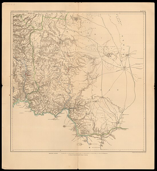
| גוטליב שומאכר: Karte des Ostjordanlandes
( |
||||||||||||||||||||||||
|---|---|---|---|---|---|---|---|---|---|---|---|---|---|---|---|---|---|---|---|---|---|---|---|---|
| אומן |
|
|||||||||||||||||||||||
| כותרת |
Karte des Ostjordanlandes |
|||||||||||||||||||||||
| מפרסם |
Rudolf Haupt |
|||||||||||||||||||||||
| תיאור |
Karte des Ostjordanlandes.... Aufgen. von Dr. G. Schumacher, Herausgeg. von DeutschenVerein zur Erforschung Palästinas. |
|||||||||||||||||||||||
| שפה | גרמנית | |||||||||||||||||||||||
| תאריך הוצאה לאור | מ- 1908 עד 1921 | |||||||||||||||||||||||
| אוסף |
|
|||||||||||||||||||||||
| מיקום נוכחי |
|
|||||||||||||||||||||||
| מיקום הוצאה | לייפציג | |||||||||||||||||||||||
| הערות | Geograph. Anst. von Wagner; In Kommission bei Rudolf Haupt; Im Auftrage des Deutschen Vereins zur Erforschung Palaestinas aufgenommen von Baurat Dr. G. Schumacher in Haifa - 1:63,360. Nebst Erlaeuterungen | |||||||||||||||||||||||
| קנה מידה | 1:700,000 cm | |||||||||||||||||||||||
| IE PID | IE13720761 | |||||||||||||||||||||||
| רוזטה שם קובץ | FL13720796 | |||||||||||||||||||||||
| מזהה רשומה בספרייה הלאומית (P3959) | 990023670370205171 | |||||||||||||||||||||||
| מוצג | יהודה ושומרון – אזור גאוגרפי ללא מוצא לים, סמוך לחופיו המזרחיים של הים התיכון | |||||||||||||||||||||||
| חיפוש בקטלוג מרחב | יהודה ושומרון, גרמנית, גוטליב שומאכר, לייפציג | |||||||||||||||||||||||
| חיפוש בקטלוג מרחב | Uebersicht der Karte des OstjordanlandesOstjordanlandesRudolf Haupt | |||||||||||||||||||||||
| מקור/צלם |
|
|||||||||||||||||||||||
| גרסאות אחרות | ||||||||||||||||||||||||
| Jpg / Tif version |
|
|||||||||||||||||||||||


.jpg)

==
רישיון
==
The copyright situation of this work is theoretically uncertain, because in the country of origin copyright lasts 70 years after the death of the author, and the date of the author's death is unknown. However, the date of creation of the work was over 120 years ago, and it is thus a reasonable assumption that the copyright has expired (see here for the community discussion). Do not use this template if the date of death of the author is known.
| |
| הקובץ הזה זוהה כקובץ חופשי מכל מגבלה ידועה תחת חוק זכויות היוצרים, כולל כל הזכויות הקשורות והסמוכות. | |
היסטוריית הקובץ
ניתן ללחוץ על תאריך/שעה כדי לראות את הקובץ כפי שנראה באותו זמן.
| תאריך/שעה | תמונה ממוזערת | ממדים | משתמש | הערה | |
|---|---|---|---|---|---|
| נוכחית | 18:40, 27 ביולי 2023 | | 11,262 × 10,322 (146.28 מ"ב) | Geagea (שיחה | תרומות) | c:User:Rillke/bigChunkedUpload.js: =={{int:filedesc}}== {{Artwork |artist = {{Creator|wikidata=Q78292}} |author = |title = Karte des Ostjordanlandes |description = Karte des Ostjordanlandes.... Aufgen. von Dr. G. Schumacher, Herausgeg. von DeutschenVerein zur Erforschung Palästinas. |language = {{Label|1=Q188}} |date = |publication date = {{other date|-|1908|1921}} |medium = |dimensions = |institution = {{Institution:Eran Laor Cartographic Collection}} |department = {{Inst... |
אין באפשרותך לדרוס את הקובץ הזה.
שימוש בקובץ
הדף הבא משתמש בקובץ הזה:
.jpg&oldid=789243474)