File:Great Salt Lake ISS 2003.jpg
둘러보기로 이동
검색으로 이동
미리 보기 크기: 612 × 600 픽셀 다른 해상도: 245 × 240 픽셀 | 490 × 480 픽셀 | 996 × 976 픽셀
원본 파일 (996 × 976 픽셀, 파일 크기: 248 KB, MIME 종류: image/jpeg)
캡션
설명
이 파일이 나타내는 바에 대한 한 줄 설명을 추가합니다
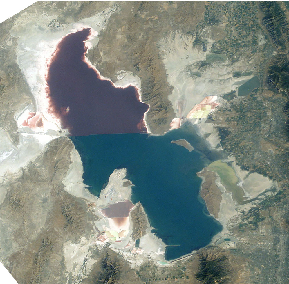
The Great Salt Lake (an endorheic lake) in Utah, taken from the International space station.
Great Salt Lake from German Wikipedia
- Description:
- Great Salt Lake, Utah, to the right (east) are the Wasatch Mountains, to the lower right is Salt Lake City, Utah. This photo is taken from the International Space Station from approximately 380 km. The railway clearly separates the north and south sections of the lake, which have different salt concentrations due to the barrier. The northern section ( Gunnison Bay) is at least two times more salty than the southern one, and shows a pink or mauve color. The water level of the lake is very low: note that the northeast arm of the lake has disappeared, and that Antelope Island is no longer an island at all.
- Sequence of landforms (west-to-east), north:
en:Curlew Valley, en:Hansel Mountains, Hansel Valley, North Promontory Mountains, en:Blue Creek Valley, Blue Spring Hills, Penrose-Bothwell, Utah - Islands:
en:Stansbury Island, en:Antelope Island, en:Fremont Island-(north) - Sequence, south:
(en:Lakeside Mountains), en:Cedar Mountains (Tooele County), en:Skull Valley (Utah), en:Stansbury Mountains, Tooele Valley, en:Oquirrh Mountains, SLC - West lake: en:Hogup Mountains, (northwest), en:Lakeside Mountains, (southwest)
- Lake center: en:Promontory Mountains
- Sequence of landforms (west-to-east), north:
- Date: 19 August 2003, GMT time: 16:37
- Colors adapted: geographically coded
- Great Salt Lake, Utah, to the right (east) are the Wasatch Mountains, to the lower right is Salt Lake City, Utah. This photo is taken from the International Space Station from approximately 380 km. The railway clearly separates the north and south sections of the lake, which have different salt concentrations due to the barrier. The northern section ( Gunnison Bay) is at least two times more salty than the southern one, and shows a pink or mauve color. The water level of the lake is very low: note that the northeast arm of the lake has disappeared, and that Antelope Island is no longer an island at all.
- Source:
- NASA's Earth Observatory [1]
- License:
| 이 파일은 NASA에서 제작하였으므로 퍼블릭 도메인입니다. NASA의 저작권 정책에 따르면 NASA의 자료는 명시하지 않는 이상 저작권의 보호를 받지 않습니다. (Template:PD-USGov, 또는 NASA 저작권 정책 문서, JPL 그림 사용 정책을 참고하세요.) | ||
 |
주의사항:
|
From : http://en.wikipedia.org/wiki/Image:Great_Salt_Lake_ISS_2003.JPG
| 주석 | 이 이미지에는 주석이 있습니다: 공용에서 주석을 보기 |
파일 역사
날짜/시간 링크를 클릭하면 해당 시간의 파일을 볼 수 있습니다.
| 날짜/시간 | 섬네일 | 크기 | 사용자 | 설명 | |
|---|---|---|---|---|---|
| 현재 | 2005년 11월 11일 (금) 09:09 | | 996 × 976 (248 KB) | Urban~commonswiki (토론 | 기여) | Great Salt Lake from German Wikipedia * Description: ** Great Salt Lake, Utah, to the right (east) are the Wasatch Mountains, to the lower right is Salt Lake City, Utah. This photo is taken from the International Space Station from a |
이 파일을 덮어쓸 수 없습니다.
이 파일을 사용하는 문서
다음 문서 1개가 이 파일을 사용하고 있습니다:
이 파일을 사용하고 있는 모든 위키의 문서 목록
다음 위키에서 이 파일을 사용하고 있습니다:
- ar.wikipedia.org에서 이 파일을 사용하고 있는 문서 목록
- arz.wikipedia.org에서 이 파일을 사용하고 있는 문서 목록
- az.wikipedia.org에서 이 파일을 사용하고 있는 문서 목록
- be.wikipedia.org에서 이 파일을 사용하고 있는 문서 목록
- bn.wikipedia.org에서 이 파일을 사용하고 있는 문서 목록
- br.wikipedia.org에서 이 파일을 사용하고 있는 문서 목록
- ceb.wikipedia.org에서 이 파일을 사용하고 있는 문서 목록
- cv.wikipedia.org에서 이 파일을 사용하고 있는 문서 목록
- da.wikipedia.org에서 이 파일을 사용하고 있는 문서 목록
- de.wikipedia.org에서 이 파일을 사용하고 있는 문서 목록
- el.wikipedia.org에서 이 파일을 사용하고 있는 문서 목록
- en.wikipedia.org에서 이 파일을 사용하고 있는 문서 목록
- Jim Bridger
- Endorheic basin
- User:Cool Hand Luke/Photos
- Portal:United States/Selected article/2006, week 37
- Portal:United States/Selected article/2006, week 38
- Portal:United States/Selected article/2006, week 39
- Portal:United States/Selected article/2006, week 40
- Wikipedia:WikiProject Lakes/Galleries/1
- Endorheic lake
- Blue Creek Valley
- eo.wikipedia.org에서 이 파일을 사용하고 있는 문서 목록
- es.wikipedia.org에서 이 파일을 사용하고 있는 문서 목록
- et.wikipedia.org에서 이 파일을 사용하고 있는 문서 목록
- fa.wikipedia.org에서 이 파일을 사용하고 있는 문서 목록
- fi.wikipedia.org에서 이 파일을 사용하고 있는 문서 목록
- fr.wikipedia.org에서 이 파일을 사용하고 있는 문서 목록
- Grand Lac Salé
- Lac Bonneville
- Wikipédia:Lumière sur/Juin 2008
- Wikipédia:Lumière sur/Grand Lac Salé
- Wikipédia:Sélection/Géographie
- Wikipédia:Sélection/Eau
- Wikipédia:Sélection/Utah
- Portail:Information géographique/Sélection
- Wikipédia:Sélection/Lacs et cours d'eau
- Portail:Salt Lake City
- Wikipédia:Sélection/Salt Lake City
- Wikipédia:Sélection/États-Unis/Bons articles/Partie II
- Julie Moschelesová
- he.wikipedia.org에서 이 파일을 사용하고 있는 문서 목록
- hi.wikipedia.org에서 이 파일을 사용하고 있는 문서 목록
- hu.wikipedia.org에서 이 파일을 사용하고 있는 문서 목록
- hy.wikipedia.org에서 이 파일을 사용하고 있는 문서 목록
- id.wikipedia.org에서 이 파일을 사용하고 있는 문서 목록
이 파일의 더 많은 사용 내역을 봅니다.
메타데이터
분류:
- Satellite pictures of Great Salt Lake
- Landforms bordering the Great Salt Lake
- Promontory Mountains
- Antelope Island
- Stansbury Island
- Fremont Island
- Hogup Mountains
- Curlew Valley
- Hansel Mountains
- North Promontory Mountains
- Blue Creek Valley
- Lakeside Mountains
- Puddle Valley
- Grassy Mountains
- Ripple Valley
- Cedar Mountains (Tooele County)
- Skull Valley (Utah)
- Stansbury Mountains
- Tooele Valley
- Oquirrh Mountains
- Pink lakes
- Lucin Cutoff