File:Grindavik area annotated.jpg
둘러보기로 이동
검색으로 이동

미리 보기 크기: 800 × 530 픽셀 다른 해상도: 320 × 212 픽셀 | 640 × 424 픽셀 | 1,024 × 678 픽셀 | 1,280 × 848 픽셀 | 2,560 × 1,696 픽셀 | 4,096 × 2,713 픽셀
원본 파일 (4,096 × 2,713 픽셀, 파일 크기: 2.32 MB, MIME 종류: image/jpeg)
캡션
설명
이 파일이 나타내는 바에 대한 한 줄 설명을 추가합니다
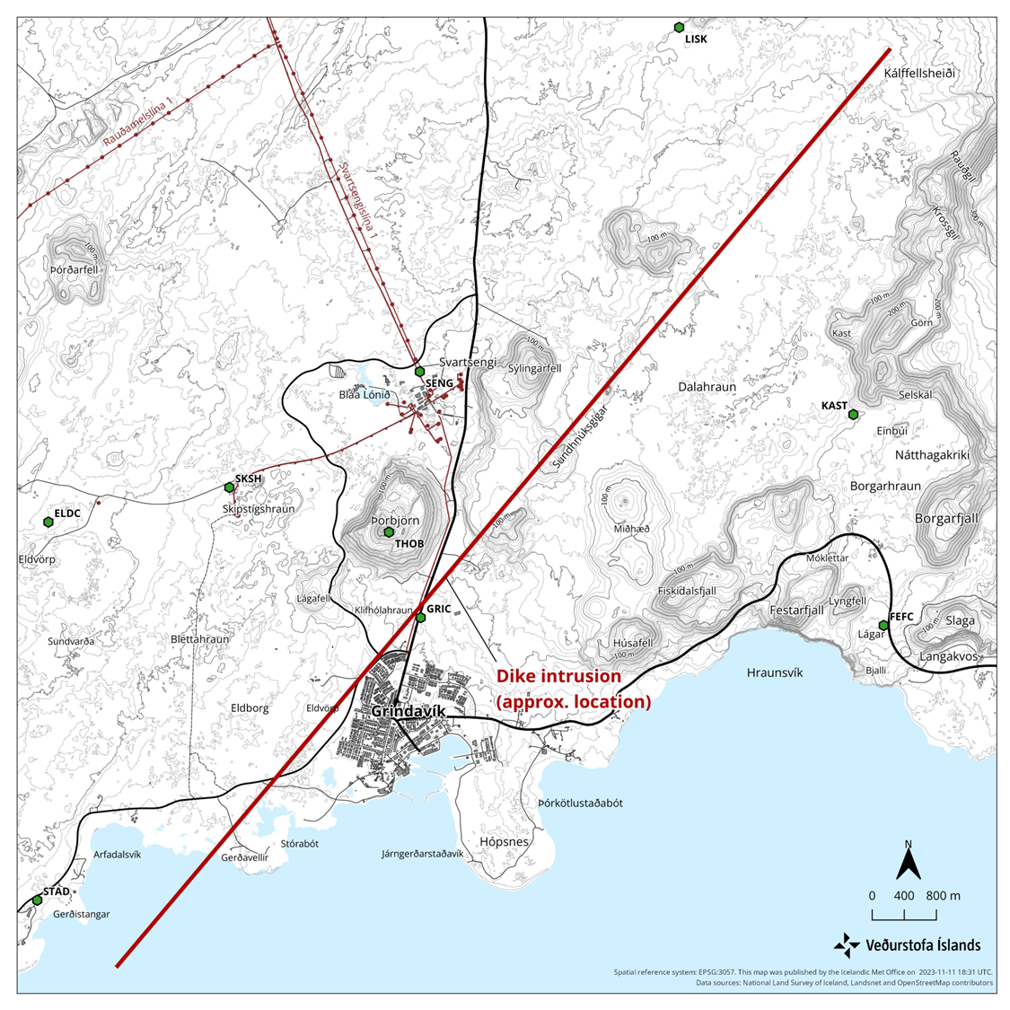
Annotated aerial view of Grindavik area with 2023 seismic disturbances
파일 설명
[편집]
| 설명 |
English: Annotated view of Grindavík and surrounding area involved in the 2023 seismic disturbances. Based on https://en.vedur.is/media/uncategorized/Kort-ragnar-enska-11-nov.png |
| 날짜 | |
| 출처 | File:Aerial_view_of_Grindavík,_Hópsnes_and_mountains.jpg |
| 저자 | Olga Ernst annotated by Prioryman |
| 카메라 위치 | | 이 지역의 다른 사진을 보기: OpenStreetMap |
|---|
라이선스
[편집]
나는 아래 작품의 저작권자로서, 이 저작물을 다음과 같은 라이선스로 배포합니다:
이 파일은 크리에이티브 커먼즈 저작자표시-동일조건변경허락 4.0 국제 라이선스로 배포됩니다.
- 이용자는 다음의 권리를 갖습니다:
- 공유 및 이용 – 저작물의 복제, 배포, 전시, 공연 및 공중송신
- 재창작 – 저작물의 개작, 수정, 2차적저작물 창작
- 다음과 같은 조건을 따라야 합니다:
- 저작자표시 – 적절한 저작자 표시를 제공하고, 라이센스에 대한 링크를 제공하고, 변경사항이 있는지를 표시해야 합니다. 당신은 합리적인 방식으로 표시할 수 있지만, 어떤 방식으로든 사용권 허가자가 당신 또는 당신의 사용을 지지하는 방식으로 표시할 수 없습니다.
- 동일조건변경허락 – 만약 당신이 이 저작물을 리믹스 또는 변형하거나 이 저작물을 기반으로 제작하는 경우, 당신은 당신의 기여물을 원저작물과 동일하거나 호환 가능한 라이선스에 따라 배포하여야 합니다.
| 주석 | 이 이미지에는 주석이 있습니다: 공용에서 주석을 보기 |
파일 역사
날짜/시간 링크를 클릭하면 해당 시간의 파일을 볼 수 있습니다.
| 날짜/시간 | 섬네일 | 크기 | 사용자 | 설명 | |
|---|---|---|---|---|---|
| 현재 | 2023년 11월 13일 (월) 14:38 | | 4,096 × 2,713 (2.32 MB) | Prioryman (토론 | 기여) | |
| 2023년 11월 13일 (월) 14:33 |  | 4,096 × 2,713 (2.32 MB) | Prioryman (토론 | 기여) | Uploaded a work by https://commons.wikimedia.org/wiki/User:Olga_Ernst from https://commons.wikimedia.org/wiki/File:Aerial_view_of_Grindav%C3%ADk,_H%C3%B3psnes_and_mountains.jpg with UploadWizard |
이 파일을 덮어쓸 수 없습니다.
이 파일을 사용하는 문서
다음 문서 1개가 이 파일을 사용하고 있습니다:
이 파일을 사용하고 있는 모든 위키의 문서 목록
다음 위키에서 이 파일을 사용하고 있습니다:
- cs.wikipedia.org에서 이 파일을 사용하고 있는 문서 목록
- de.wikipedia.org에서 이 파일을 사용하고 있는 문서 목록
- en.wikipedia.org에서 이 파일을 사용하고 있는 문서 목록
- es.wikipedia.org에서 이 파일을 사용하고 있는 문서 목록
- fr.wikipedia.org에서 이 파일을 사용하고 있는 문서 목록
- hu.wikipedia.org에서 이 파일을 사용하고 있는 문서 목록
- is.wikipedia.org에서 이 파일을 사용하고 있는 문서 목록
- ko.wikipedia.org에서 이 파일을 사용하고 있는 문서 목록
- nl.wikipedia.org에서 이 파일을 사용하고 있는 문서 목록
범주:
- Hópsnes (Grindavík)
- Aerial photographs of Grindavík
- Húsafell (Grindavík)
- Sýlingafell
- Remote views of Þorbjörn
- 2022 aerial photographs of Iceland
- Aerial photographs of Þorbjörn
- Svartsengi power station
- Hagafell (Grindavík)
- Sundhnúkagígaröðin
- Igneous intrusions in Iceland in 2023
- Geology of Reykjanes (peninsula), South-west Iceland
- Igneous intrusions of the Svartsengi volcanic system
- Geological maps of Reykjanes peninsula, Iceland
- Volcano-tectonic episode in 2023 centered on the Svartsengi volcanic system
- Igneous intrusion feeding the 2023 Sundhnúkur Eruption
- Blue Lagoon in November 2023