File:Growth of Habsburg territories.jpg
둘러보기로 이동
검색으로 이동

미리 보기 크기: 800 × 475 픽셀 다른 해상도: 320 × 190 픽셀 | 640 × 380 픽셀 | 1,024 × 608 픽셀 | 1,280 × 760 픽셀 | 2,275 × 1,350 픽셀
원본 파일 (2,275 × 1,350 픽셀, 파일 크기: 1.02 MB, MIME 종류: image/jpeg)
캡션
설명
이 파일이 나타내는 바에 대한 한 줄 설명을 추가합니다
파일 설명[편집]
| 설명 |
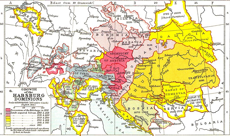
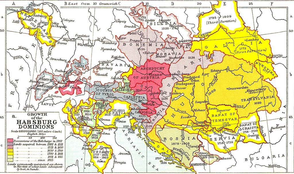
English: Growth of the Habsburg Dominions. Territorial changes of the Austrian Habsburg branch. |
| 날짜 | |
| 출처 |
Ramsay Muir, 1911, Philips' New Historical Atlas for Students, plate 25a, 1st edition, Philip & Son. https://openlibrary.org/books/OL25906533M/Philips%27_new_historical_atlas_for_students |
| 저자 | Ramsay Muir |
라이선스[편집]
|
이 작품은 미국, 그리고 저작권 보호 기간이 저작자 사후 70년, 또는 그 이하인 모든 국가에서 퍼블릭 도메인입니다. 이 작품은 1929년 1월 1일 이전에 출판하였으므로 미국에서 퍼블릭 도메인입니다. | |
| 이 저작물은 모든 저작인접권을 포함한 저작권법하의 규제로부터 자유로운 것으로 확인되었습니다. | |
파일 역사
날짜/시간 링크를 클릭하면 해당 시간의 파일을 볼 수 있습니다.
| 날짜/시간 | 섬네일 | 크기 | 사용자 | 설명 | |
|---|---|---|---|---|---|
| 현재 | 2022년 11월 25일 (금) 19:37 | | 2,275 × 1,350 (1.02 MB) | Gyalu22 (토론 | 기여) | Reverted to version as of 08:54, 16 March 2016 (UTC) |
| 2017년 12월 23일 (토) 19:24 |  | 2,275 × 1,350 (1.03 MB) | MAXHO (토론 | 기여) | Reverted to version as of 2015 according with cited sources | |
| 2016년 3월 16일 (수) 08:54 |  | 2,275 × 1,350 (1.02 MB) | Fakirbakir (토론 | 기여) | back to the original version | |
| 2015년 11월 30일 (월) 17:12 |  | 2,275 × 1,350 (1.03 MB) | Spiridon Ion Cepleanu (토론 | 기여) | Some details according with « Grosser Atlas zur Weltgeschichte » (H.E.Stier, dir.) Westermann 1985, ISBN 3-14-100919-8, « Putzger historischer Weltatlas Cornelsen » 1990, ISBN 3-464-00176-8 & « Történelmi atlasz a középiskolák számára », K... | |
| 2014년 5월 13일 (화) 21:31 |  | 2,275 × 1,350 (1.02 MB) | CSvBibra (토론 | 기여) | contrast | |
| 2009년 2월 15일 (일) 20:27 |  | 2,275 × 1,350 (956 KB) | Bizso (토론 | 기여) | {{Information |Description={{en|1=Growth of Habsburg territories.}} |Source=[http://www.heritage-history.com/maps/philips/phil025a.jpg] |Author=unknown |Date=unnowkn |Permission= |other_versions= }} <!--{{ImageUpload|full}}--> |
이 파일을 덮어쓸 수 없습니다.
이 파일을 사용하는 문서
다음 문서 11개가 이 파일을 사용하고 있습니다:
- Atlas of Bosnia and Herzegovina
- Atlas of Croatia
- Atlas of Hungary
- Atlas of Serbia
- Atlas of Slovenia
- Atlas of Székely Land
- User:J budissin/Uploads/BiH/2015 November 21-30
- User:J budissin/Uploads/BiH/2016 March 11-20
- User:J budissin/Uploads/BiH/2017 December 21-31
- Commons:Deletion requests/Archive/2013/09/09
- Commons:Deletion requests/File:Austrian empire.png
이 파일을 사용하고 있는 모든 위키의 문서 목록
다음 위키에서 이 파일을 사용하고 있습니다:
- als.wikipedia.org에서 이 파일을 사용하고 있는 문서 목록
- ar.wikipedia.org에서 이 파일을 사용하고 있는 문서 목록
- azb.wikipedia.org에서 이 파일을 사용하고 있는 문서 목록
- ba.wikipedia.org에서 이 파일을 사용하고 있는 문서 목록
- be-tarask.wikipedia.org에서 이 파일을 사용하고 있는 문서 목록
- be.wikipedia.org에서 이 파일을 사용하고 있는 문서 목록
- bg.wikipedia.org에서 이 파일을 사용하고 있는 문서 목록
- bn.wikipedia.org에서 이 파일을 사용하고 있는 문서 목록
- br.wikipedia.org에서 이 파일을 사용하고 있는 문서 목록
- ca.wikipedia.org에서 이 파일을 사용하고 있는 문서 목록
- cs.wikipedia.org에서 이 파일을 사용하고 있는 문서 목록
- da.wikipedia.org에서 이 파일을 사용하고 있는 문서 목록
- el.wikipedia.org에서 이 파일을 사용하고 있는 문서 목록
- en.wikipedia.org에서 이 파일을 사용하고 있는 문서 목록
- es.wikipedia.org에서 이 파일을 사용하고 있는 문서 목록
- et.wikipedia.org에서 이 파일을 사용하고 있는 문서 목록
- fa.wikipedia.org에서 이 파일을 사용하고 있는 문서 목록
- fi.wikipedia.org에서 이 파일을 사용하고 있는 문서 목록
- frr.wikipedia.org에서 이 파일을 사용하고 있는 문서 목록
- fr.wikipedia.org에서 이 파일을 사용하고 있는 문서 목록
이 파일의 더 많은 사용 내역을 봅니다.