File:Hurricane Bill in First Full Disk Thermal Image from GOES 14.jpg
קפיצה לניווט
קפיצה לחיפוש
גודל התצוגה המקדימה הזאת: 600 × 600 פיקסלים. רזולוציות אחרות: 240 × 240 פיקסלים | 480 × 480 פיקסלים | 768 × 768 פיקסלים | 1,024 × 1,024 פיקסלים | 2,048 × 2,048 פיקסלים | 2,711 × 2,711 פיקסלים.
לקובץ המקורי (2,711 × 2,711 פיקסלים, גודל הקובץ: 1.18 מ"ב, סוג MIME: image/jpeg)
כיתובים
כיתובים
נא להוסיף משפט שמסביר מה הקובץ מייצג
תקציר
[עריכה]
| תיאור |
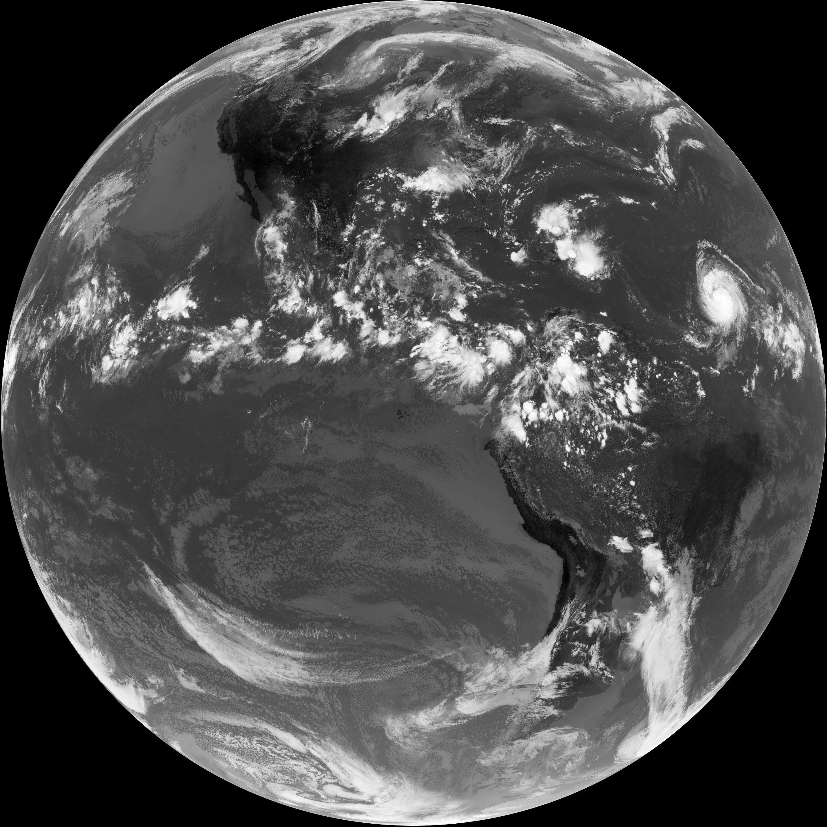
English: This is the first full-disk thermal infra-red (IR) image taken by GOES 14, showing radiation with a wavelength of 10.7 micrometers emanating from Earth. Infra-red images are useful because they provide information about temperatures. A wavelength of 10.7 micrometers is 15 times longer than the longest wavelength of light (red) that people can see, but scientists can turn the data into a picture by having a computer display cold temperatures as bright white and hot temperatures as black. The hottest (blackest) features in the scene are land surfaces; the coldest (whitest) features in the scene are clouds. In the heat of the midday sun, the exposed rock in sparsely vegetated mountain ranges and high-altitude deserts in western North and South America are dark. In North America, the temperatures cool (fade to lighter grey) along a gradient from west to east, as the semi-deserts of the West and South-west transition to the grasslands and crop-lands of the Great Plains, which transition to forests in the East. A band of scattered storms across the equatorial Pacific shows the location of the Inter-tropical Convergence Zone, which is a belt of showers and thunderstorms that persists near the equator year round. Need help precisely locating the equator? Look for the dark (hot) spots in the Pacific Ocean west of South America: those are the Galapagos Islands, and the equator passes through the northern tip of the largest island. Perhaps the most significant features related to U.S. weather appear in the upper right quadrant of the disk: the remnants of Tropical Storm Claudette drenching the eastern Gulf Coast, Tropical Depression Ana unwinding over Puerto Rico and the Dominican Republic, and Hurricane Bill approaching from the central Atlantic. |
| תאריך יצירה | |
| מקור | NASA Earth Observatory |
| יוצר | GOES science team |
Instrument: GOES
רישיון
[עריכה]
| קובץ זה נמצא ברשות הציבור מכיוון שהוא נוצר על ידי נאס"א. מדיניות זכויות היוצרים של נאס"א קובעת ש"חומרים של NASA אינם מוגנים בזכויות יוצרים אלא אם צוין אחרת". (דף מדיניות זכויות היוצרים ב-NASA או מדיניות שימוש בתמונות ב-JPL). | ||
 |
אזהרות:
|
| Annotations | This image is annotated: View the annotations at Commons |
היסטוריית הקובץ
ניתן ללחוץ על תאריך/שעה כדי לראות את הקובץ כפי שנראה באותו זמן.
| תאריך/שעה | תמונה ממוזערת | ממדים | משתמש | הערה | |
|---|---|---|---|---|---|
| נוכחית | 08:52, 19 באוגוסט 2009 | | 2,711 × 2,711 (1.18 מ"ב) | Originalwana (שיחה | תרומות) | {{Information |Description={{en|1=This is the first full-disk thermal infra-red (IR) image taken by GOES 14, showing radiation with a wavelength of 10.7 micrometers emanating from Earth. Infra-red images are useful because they provide information about t |
אין באפשרותך לדרוס את הקובץ הזה.
שימוש בקובץ
הדפים הבאים משתמשים בקובץ הזה:
שימוש גלובלי בקובץ
אתרי הוויקי השונים הבאים משתמשים בקובץ זה:
- שימוש באתר beta.wikiversity.org
- שימוש באתר ca.wikipedia.org
- שימוש באתר cs.wikipedia.org
- שימוש באתר en.wikipedia.org
- שימוש באתר en.wikiversity.org
- שימוש באתר he.wikipedia.org
- שימוש באתר ja.wikipedia.org
- שימוש באתר ko.wikipedia.org
- שימוש באתר vi.wikipedia.org