File:Illa de Xàtiva.jpg
קפיצה לניווט
קפיצה לחיפוש

גודל התצוגה המקדימה הזאת: 619 × 599 פיקסלים. רזולוציות אחרות: 248 × 240 פיקסלים | 496 × 480 פיקסלים | 793 × 768 פיקסלים | 1,057 × 1,024 פיקסלים | 2,275 × 2,203 פיקסלים.
לקובץ המקורי (2,275 × 2,203 פיקסלים, גודל הקובץ: 1.5 מ"ב, סוג MIME: image/jpeg)
כיתובים
כיתובים
נא להוסיף משפט שמסביר מה הקובץ מייצג
תקציר
[עריכה]
| תיאור |
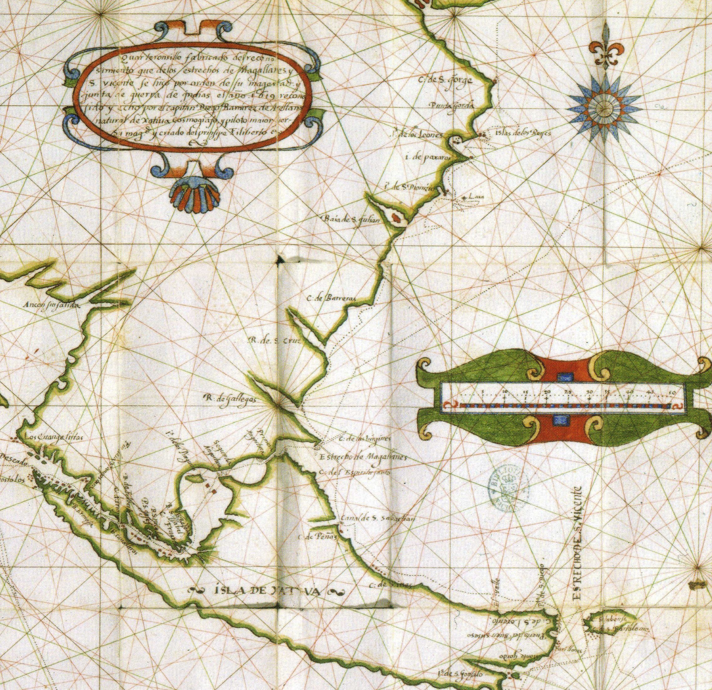
Català: Mapa de Diego Ramírez de Arellano amb l'Illa de Xàtiva, actualment Isla Grande de Tierra del Fuego .
English: Part of a map by Diego Ramírez de Arellano that includes the toponym Isla de Xativa, nowadays Isla Grande de Tierra del Fuego .
Español: Parte del mapa de Diego Ramírez de Arellano contenido en el manuscrito Reconocimiento de los estrechos de Magallanes y S. Vicente, con algunas cosas curiosas de navegación (BNE Mss/3190). El mapa se titula "Quarteronsillo fabricado del reconosimiento que de los estrechos de Magallanes y S. Viçente se hiço por orden de su magestad y junta de guerra de Indias el año 1619 reconosido y echo por el capitan Diego Ramirez de Arellano natural de Xatiua Cosmografo y piloto maior por su magestad y criado del prinsipe Filiberto". Incluye el topónimo Isla de Xativa en la actualmente denominada Isla Grande de Tierra del Fuego . |
| תאריך יצירה | |
| מקור | http://www.histo.cat/1/illa_de_xativa3.jpg |
| יוצר | Diego Ramírez de Arellano |
| אישורים והיתרים (שימוש חוזר בקובץ זה) |
Multi-license CC-BY-SA-3.0 and GFDL |
| גרסאות אחרות | Illa de Xàtiva millorat.jpg |
רישיון
[עריכה]
|
יצירה זו נמצאת בנחלת הכלל במדינת המקור ובמדינות אחרות בהם תקופת זכויות היוצרים היא משך חיי היוצר ו-70 שנה (או פחות) מפטירתו.
| |
| הקובץ הזה זוהה כקובץ חופשי מכל מגבלה ידועה תחת חוק זכויות היוצרים, כולל כל הזכויות הקשורות והסמוכות. | |
היסטוריית הקובץ
ניתן ללחוץ על תאריך/שעה כדי לראות את הקובץ כפי שנראה באותו זמן.
| תאריך/שעה | תמונה ממוזערת | ממדים | משתמש | הערה | |
|---|---|---|---|---|---|
| נוכחית | 17:33, 22 ביולי 2015 | | 2,203 × 2,275 (1.5 מ"ב) | Mcapdevila (שיחה | תרומות) | Map in color of Diego Ramírez de Arellano depicting the actual Island of Tierra de Fuego with the name of Illa de Xàtiva, after he did circumnavigated an chartered the whole island for the very first time. |
| 08:43, 21 ביוני 2007 |  | 187 × 250 (13 ק"ב) | Pere prlpz (שיחה | תרומות) | {{Information |Description={{ca|Mapa de ca:Diego Ramírez de Arellano amb l'ca:Illa de Xàtiva, actualment Tierra de Fuego}} |Source=Web del diari Levante http://www.levante-emv.com/secciones/noticia.jsp?pNumEjemplar=3562&pIdSeccion=9&pIdNot |
אין באפשרותך לדרוס את הקובץ הזה.
שימוש בקובץ
הדף הבא משתמש בקובץ הזה:
שימוש גלובלי בקובץ
אתרי הוויקי השונים הבאים משתמשים בקובץ זה:
- שימוש באתר ca.wikipedia.org
- שימוש באתר en.wikipedia.org
- שימוש באתר es.wikipedia.org
- שימוש באתר he.wikipedia.org