File:IrishSeaReliefMap.jpg
קפיצה לניווט
קפיצה לחיפוש
גודל התצוגה המקדימה הזאת: 415 × 600 פיקסלים. רזולוציות אחרות: 166 × 240 פיקסלים | 332 × 480 פיקסלים | 531 × 768 פיקסלים | 1,043 × 1,507 פיקסלים.
לקובץ המקורי (1,043 × 1,507 פיקסלים, גודל הקובץ: 2.15 מ"ב, סוג MIME: image/jpeg)
כיתובים
כיתובים
נא להוסיף משפט שמסביר מה הקובץ מייצג
תקציר[עריכה]
| תיאור |
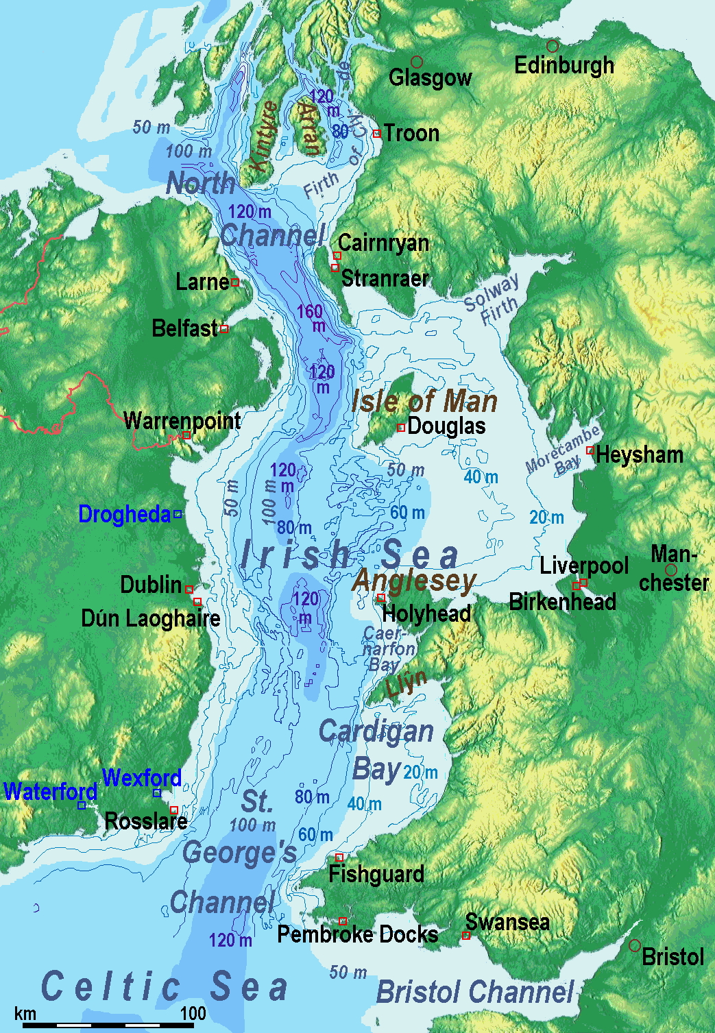
A map of the en:Irish Sea. Major ports shown with red marks. freight-only ports in blue. |
| תאריך יצירה | old map 2005-08-03; new map 2014-05-11 |
| מקור | old map: http://www.vindaloo.uklinux.net/jjg/code/tmutils.html-> new map: Maps for Free and נוצר על־ידי מעלה היצירה |
| יוצר | old one Users SFC9394, Seabhcan on en.wikipedia, new one Ulamm (talk) 01:37, 11 May 2014 (UTC) |
| אישורים והיתרים (שימוש חוזר בקובץ זה) |
old map: from http://www.vindaloo.uklinux.net/jjg/code/tmutils.html. Released to public domain by creator. |
| גרסאות אחרות |
History of the od map[עריכה]
Old map riginally from en.wikipedia; description page is (was) here
- 14:22, 20 March 2006 SFC9394 461×561 (85,860 bytes) (Corrected locations for Cairnryan & Stranraer)
- 10:56, 25 November 2005 Seabhcan 461×561 (73,292 bytes) (Removed the ports of Heysham and Fleetwood, to which en:User:Robdurbar took offence. )
- 16:23, 3 August 2005 Seabhcan 461×561 (95,162 bytes) (Added channel names)
- 15:50, 3 August 2005 Seabhcan 461×561 (93,219 bytes) (A map of the en:Irish Sea Major ports shown in red. freight only ports in blue. from [1]. Released to public domain by creator.)
Sources of information for the new map[עריכה]
- internal report Nr. 174 of the National Oceanography Centre (Liverpool)
- http://www.dcenr.gov.ie (Department of Communications, Energy and Natural Resources) -> IOSEA4Annex–Master–r02–Fiinal.pdf (Fourth Strategic Environmental Assessment for Oil and Gas ACtivity in Irelands Offshore Waters) -> figures 2.1 & 2.2a
רישיון[עריכה]
אני, בעל זכויות היוצרים על עבודה זו, מפרסם בזאת את העבודה תחת הרישיון הבא:
הקובץ הזה מתפרסם לפי תנאי רישיון קריאייטיב קומונז ייחוס-שיתוף זהה 3.0 לא מותאם.
- הנכם רשאים:
- לשתף – להעתיק, להפיץ ולהעביר את העבודה
- לערבב בין עבודות – להתאים את העבודה
- תחת התנאים הבאים:
- ייחוס – יש לתת ייחוס הולם, לתת קישור לרישיון, ולציין אם נעשו שינויים. אפשר לעשות את זה בכל צורה סבירה, אבל לא בשום צורה שמשתמע ממנה שמעניק הרישיון תומך בך או בשימוש שלך.
- שיתוף זהה – אם תיצרו רמיקס, תשנו, או תבנו על החומר, חובה עליכם להפיץ את התרומות שלך לפי תנאי רישיון זהה או תואם למקור.
(Uploaded using CommonsHelper or PushForCommons)
היסטוריית הקובץ
ניתן ללחוץ על תאריך/שעה כדי לראות את הקובץ כפי שנראה באותו זמן.
| תאריך/שעה | תמונה ממוזערת | ממדים | משתמש | הערה | |
|---|---|---|---|---|---|
| נוכחית | 11:42, 13 במאי 2014 | | 1,507 × 1,043 (2.15 מ"ב) | Ulamm (שיחה | תרומות) | optimized colour scale |
| 14:17, 12 במאי 2014 |  | 1,507 × 1,043 (1.87 מ"ב) | Ulamm (שיחה | תרומות) | more names, smaller letters | |
| 12:25, 11 במאי 2014 |  | 1,449 × 1,043 (1.73 מ"ב) | Ulamm (שיחה | תרומות) | depths and names of bays and inlets | |
| 10:56, 11 במאי 2014 |  | 1,449 × 1,043 (1.71 מ"ב) | Ulamm (שיחה | תרומות) | land colours lightened | |
| 02:22, 11 במאי 2014 |  | 1,449 × 1,043 (1.7 מ"ב) | Ulamm (שיחה | תרומות) | more ports | |
| 01:50, 11 במאי 2014 |  | 1,449 × 1,043 (1.69 מ"ב) | Ulamm (שיחה | תרומות) | completion outside the Irish Sea | |
| 01:39, 11 במאי 2014 |  | 1,449 × 1,043 (1.68 מ"ב) | Ulamm (שיחה | תרומות) | completely new map | |
| 09:01, 1 בנובמבר 2006 |  | 561 × 461 (84 ק"ב) | Korrigan (שיחה | תרומות) | {{Information| |Description= A map of the en:Irish Sea Major ports shown in red. freight only ports in blue. |Source= |Date= |Author=Users SFC9394, Seabhcan on [http://en.wikipedia.org en.wikipedia] |Permiss |
אין באפשרותך לדרוס את הקובץ הזה.
שימוש בקובץ
הדף הבא משתמש בקובץ הזה:
שימוש גלובלי בקובץ
אתרי הוויקי השונים הבאים משתמשים בקובץ זה:
- שימוש באתר af.wikipedia.org
- שימוש באתר an.wikipedia.org
- שימוש באתר ast.wikipedia.org
- שימוש באתר ba.wikipedia.org
- שימוש באתר be.wikipedia.org
- שימוש באתר bg.wikipedia.org
- שימוש באתר bn.wikipedia.org
- שימוש באתר br.wikipedia.org
- שימוש באתר ca.wikipedia.org
- שימוש באתר cs.wikipedia.org
- שימוש באתר cv.wikipedia.org
- שימוש באתר cy.wikipedia.org
- שימוש באתר da.wikipedia.org
- שימוש באתר el.wikipedia.org
- שימוש באתר eo.wikipedia.org
- שימוש באתר es.wikipedia.org
- שימוש באתר eu.wikipedia.org
- שימוש באתר fa.wikipedia.org
- שימוש באתר fy.wikipedia.org
- שימוש באתר gl.wikipedia.org
- שימוש באתר gv.wikipedia.org
- שימוש באתר he.wikipedia.org
- שימוש באתר hu.wikipedia.org
- שימוש באתר hu.wiktionary.org
- שימוש באתר id.wikipedia.org
- שימוש באתר is.wikipedia.org
- שימוש באתר ka.wikipedia.org
- שימוש באתר kk.wikipedia.org
- שימוש באתר ko.wikipedia.org
- שימוש באתר ku.wikipedia.org
- שימוש באתר lmo.wikipedia.org
צפייה בשימושים גלובליים נוספים של קובץ זה.