File:Island of Ireland location map Kerry.svg
קפיצה לניווט
קפיצה לחיפוש

גודל התצוגה המקדימה הזאת מסוג PNG של קובץ ה־SVG הזה: 481 × 599 פיקסלים. רזולוציות אחרות: 192 × 240 פיקסלים | 385 × 480 פיקסלים | 616 × 768 פיקסלים | 822 × 1,024 פיקסלים | 1,643 × 2,048 פיקסלים | 1,450 × 1,807 פיקסלים.
לקובץ המקורי (קובץ SVG, הגודל המקורי: 1,450 × 1,807 פיקסלים, גודל הקובץ: 642 ק"ב)
כיתובים
כיתובים
נא להוסיף משפט שמסביר מה הקובץ מייצג
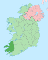
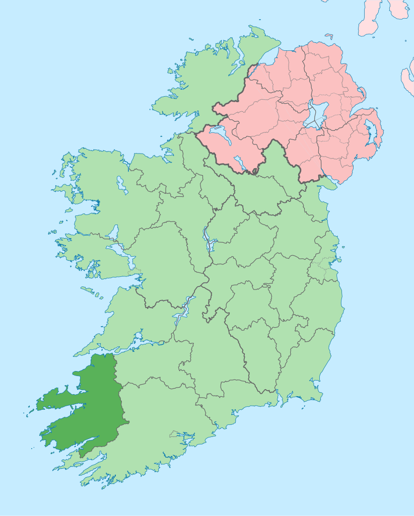
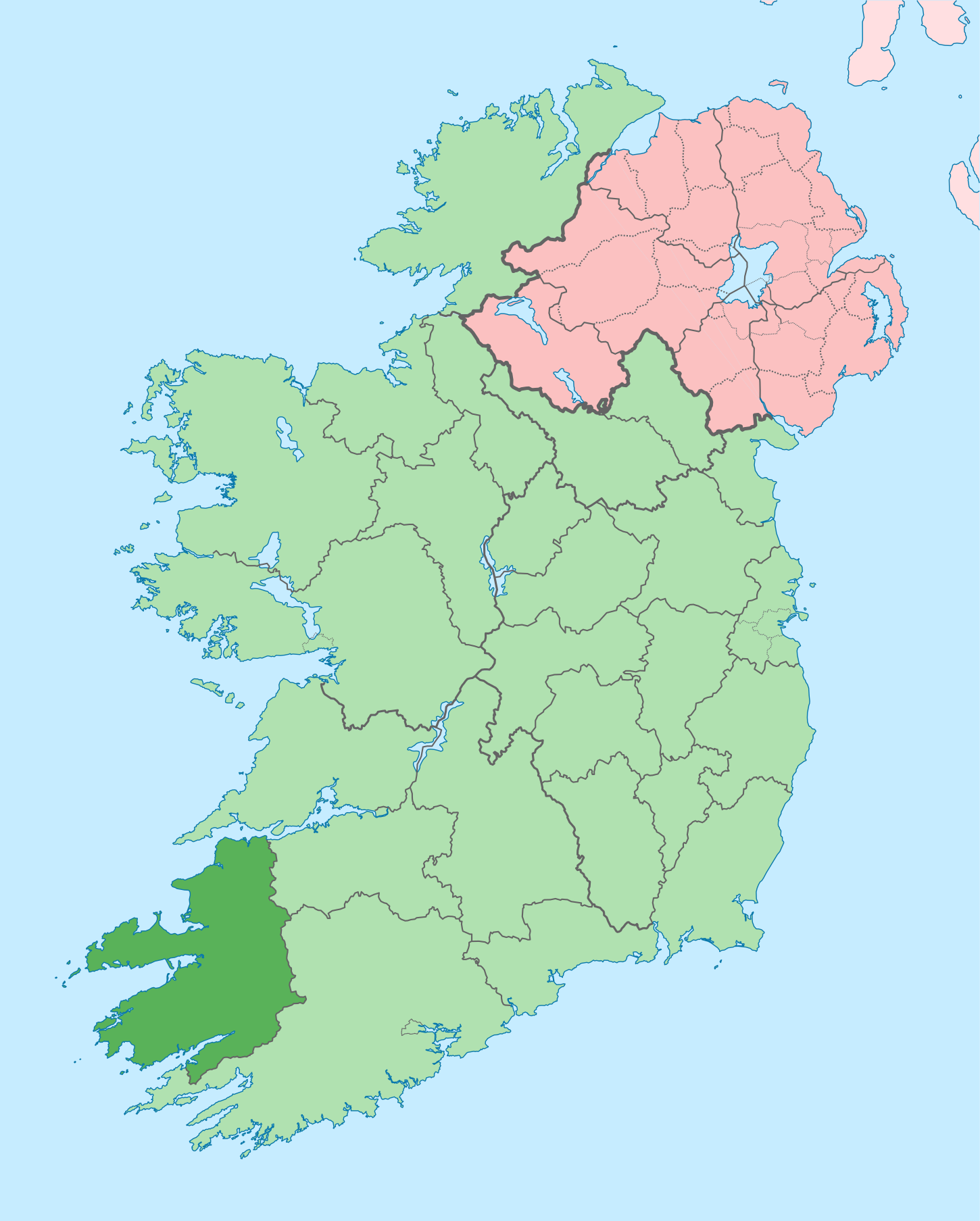
Kerry on a map
| תיאור |
English: The island of Ireland, showing international border between Ireland and Northern Ireland, traditional provinces, traditional counties, and local authority areas in Ireland and Northern Ireland. |
| תאריך יצירה | (UTC) |
| מקור | |
| יוצר |
|
| זוהי תמונה מרוטשת, זאת אומרת שהתמונה שונתה בצורה דיגיטלית מהמקור. Modifications: Coloured in regions with county of article highlighted. את התמונה המקורית ניתן לראות ב: Island of Ireland location map.svg. השינוי בוצע על ידי Mabuska.
|
אני, בעל זכויות היוצרים על עבודה זו, מפרסם בזאת את העבודה תחת הרישיון הבא:
הקובץ הזה מתפרסם לפי תנאי רישיון קריאייטיב קומונז ייחוס-שיתוף זהה 3.0 לא מותאם.
- הנכם רשאים:
- לשתף – להעתיק, להפיץ ולהעביר את העבודה
- לערבב בין עבודות – להתאים את העבודה
- תחת התנאים הבאים:
- ייחוס – יש לתת ייחוס הולם, לתת קישור לרישיון, ולציין אם נעשו שינויים. אפשר לעשות את זה בכל צורה סבירה, אבל לא בשום צורה שמשתמע ממנה שמעניק הרישיון תומך בך או בשימוש שלך.
- שיתוף זהה – אם תיצרו רמיקס, תשנו, או תבנו על החומר, חובה עליכם להפיץ את התרומות שלך לפי תנאי רישיון זהה או תואם למקור.
יומן העלאה מקורי[עריכה]
This image is a derivative work of the following images:
- File:Island_of_Ireland_location_map.svg licensed with Cc-by-sa-3.0
- 2010-03-06T20:43:33Z Rannpháirtí anaithnid 1450x1807 (679207 Bytes) Fix incorrectly coloured isands.
- 2010-03-03T22:19:29Z Rannpháirtí anaithnid 1450x1807 (679744 Bytes) {{Information |Description={{de|Positionskarte von [[:de:Irland|Irland]]}} Quadratische Plattkarte, N-S-Streckung 170 %. Geographische Begrenzung der Karte: * N: 55.6° N * S: 51.2° N * W: 11.0° W * O: 5.0° W {{en|Location
Uploaded with derivativeFX
היסטוריית הקובץ
ניתן ללחוץ על תאריך/שעה כדי לראות את הקובץ כפי שנראה באותו זמן.
| תאריך/שעה | תמונה ממוזערת | ממדים | משתמש | הערה | |
|---|---|---|---|---|---|
| נוכחית | 15:58, 26 ביוני 2020 | | 1,807 × 1,450 (642 ק"ב) | Chipmunkdavis (שיחה | תרומות) | Per the Local Government Reform Act 2014, joining both Tipperarys and both Waterfords (and removing Limerick City code). Colouring in islands, cleaning up and grouping code to remove stray objects and show Galway and Lough Ree. |
| 00:48, 19 ביולי 2010 |  | 1,807 × 1,450 (821 ק"ב) | Mabuska (שיחה | תרומות) | {{Information |Description={{en|The island of Ireland, showing international border between Northern Ireland and Republic of Ireland, traditional provinces, traditional counties, and local authority areas in the Republic of Ireland and Northern Ireland.}} |
אין באפשרותך לדרוס את הקובץ הזה.
שימוש בקובץ
הדפים הבאים משתמשים בקובץ הזה:
- Category:Archaeological sites in County Kerry
- Category:Beaches of County Kerry
- Category:Births in County Kerry
- Category:Castles in County Kerry
- Category:County Kerry
- Category:Maps of County Kerry
- Category:Murals in County Kerry
- Category:Museums in County Kerry
- Category:People of County Kerry
- Category:Protected areas of County Kerry
- Category:Rivers of County Kerry
- Category:Roads in County Kerry
שימוש גלובלי בקובץ
אתרי הוויקי השונים הבאים משתמשים בקובץ זה:
- שימוש באתר ar.wikipedia.org
- שימוש באתר ast.wikipedia.org
- שימוש באתר bg.wikipedia.org
- שימוש באתר br.wikipedia.org
- An Daingean
- Trá Lí
- Mainistir Ó dTorna
- Abhainn an Scáil
- Ard Fhearta
- Baile na nGall
- Baile an Sceilg
- Dairbhre
- An Baile Dubh
- Baile an Fheirtéaraigh
- Baile Uí Thaidhg
- Baile Mhic Eilegóid
- Cathair Uí Mhóráin
- Patrom:Kontelezh Ciarraí
- Brosnach
- Cathair Dhónaill
- Cathair Saidhbhín
- Béal Átha Longfoirt
- An Siopa Dubh
- Caisleán Ghriaire
- שימוש באתר ca.wikipedia.org
- Comtat de Kerry
- Killarney
- Tralee
- Kenmare
- Plantilla:Comtat Kerry
- Listowel
- Baile an Fheirtéaraigh
- Baile an Sceilg
- Ceann Trá
- An Daingean
- Dún Chaoin
- Feothanach
- An Clochán
- Cé Bhréannain
- Lios Póil
- Cathair Dónall
- Baile na nGall
- Abhainn an Scáil
- Ballylongford
- Tarbert
- Ballybunion
- An Fosadh
- Baile an Mhuilinn (Kerry)
- An Com
- שימוש באתר ceb.wikipedia.org
- שימוש באתר cs.wikipedia.org
צפייה בשימושים גלובליים נוספים של קובץ זה.