File:IsraelCVFRchart-BorderNorth copy.jpg
קפיצה לניווט
קפיצה לחיפוש

גודל התצוגה המקדימה הזאת: 442 × 599 פיקסלים. רזולוציות אחרות: 177 × 240 פיקסלים | 354 × 480 פיקסלים | 567 × 768 פיקסלים | 756 × 1,024 פיקסלים | 1,308 × 1,772 פיקסלים.
לקובץ המקורי (1,308 × 1,772 פיקסלים, גודל הקובץ: 2.01 מ"ב, סוג MIME: image/jpeg)
כיתובים
כיתובים
נא להוסיף משפט שמסביר מה הקובץ מייצג
| תיאור |
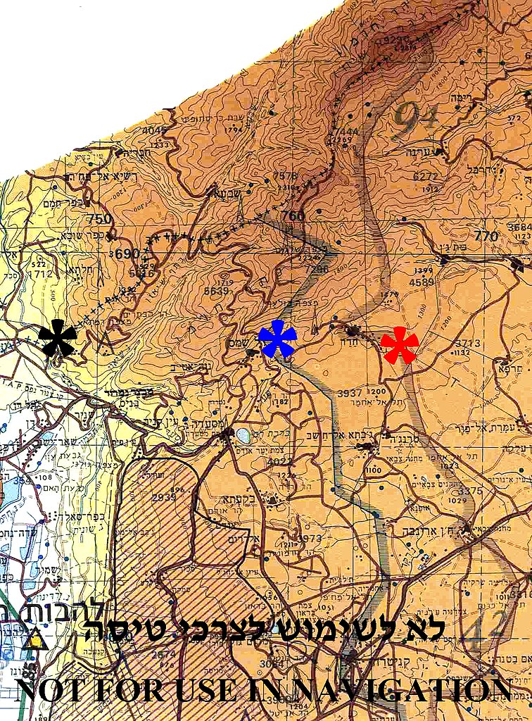
English: Borders between Israel, Syria and Lebanon in Mount Hermon region
The (+++) line between Israel and Lebanon – marked by black asterisk Disengagement Israeli front line with Syria (1974) - marked by blue asterisk Disengagement Syrian front line with Israel (1974) - marked by red asterisk. |
||
| תאריך יצירה | |||
| מקור | Aeronautical Information Publication - Domestic (AIP) of the Israel Civil Aviation Administration – presently Civil Aviation Authority (CAA) | ||
| יוצר | Etan Tal | ||
| אישורים והיתרים (שימוש חוזר בקובץ זה) |
|
Image to be used for illustration of aviation articles. Not for actual navigation. Original image is public domain (State Regulations) - uploader added the disclaimers prohibiting navigation use in compliance with normal aviation practice. Modified image released to the public domain as well.
היסטוריית הקובץ
ניתן ללחוץ על תאריך/שעה כדי לראות את הקובץ כפי שנראה באותו זמן.
| תאריך/שעה | תמונה ממוזערת | ממדים | משתמש | הערה | |
|---|---|---|---|---|---|
| נוכחית | 01:08, 12 באוקטובר 2009 | | 1,772 × 1,308 (2.01 מ"ב) | Etan J. Tal (שיחה | תרומות) | {{Information |Description={{en|1=Borders between Israel, Syria and Lebanon in Mount Hermon region The Blue Line between Israel and Lebanon – marked by black asterisk Disengagement Israeli front line with Syria (1974) - marked by blue asterisk Disen |
אין באפשרותך לדרוס את הקובץ הזה.
שימוש בקובץ
אין דפים המשתמשים בקובץ זה.
שימוש גלובלי בקובץ
אתרי הוויקי השונים הבאים משתמשים בקובץ זה:
- שימוש באתר ar.wikipedia.org
- שימוש באתר arz.wikipedia.org
- שימוש באתר ca.wikipedia.org
- שימוש באתר en.wikipedia.org
- שימוש באתר he.wikipedia.org
- שימוש באתר tt.wikipedia.org