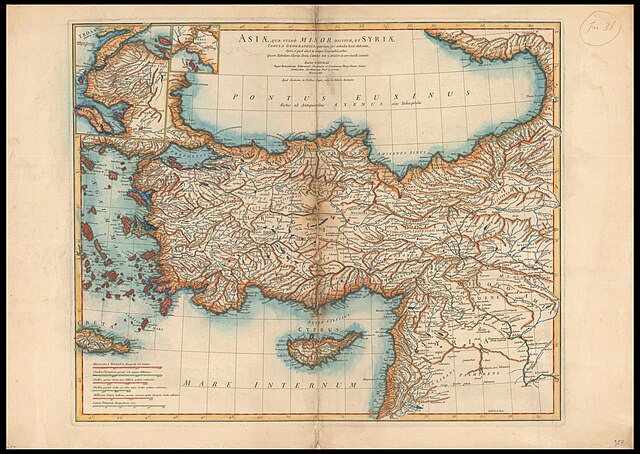
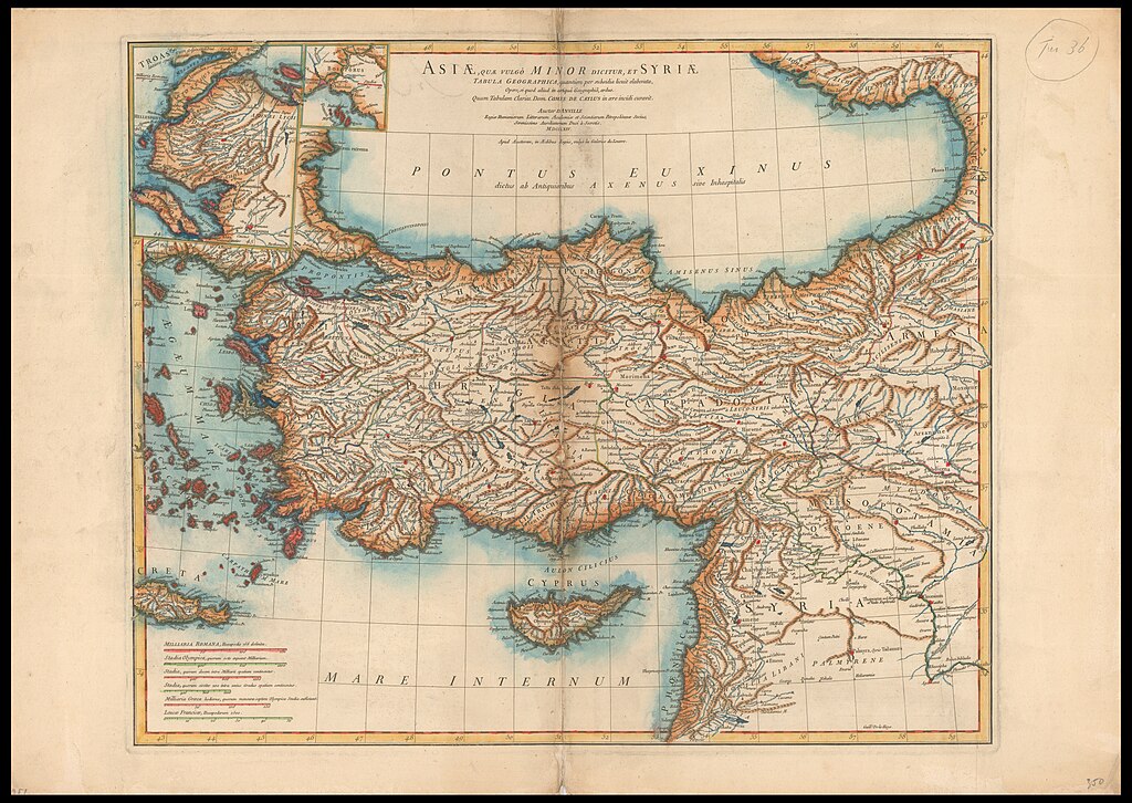
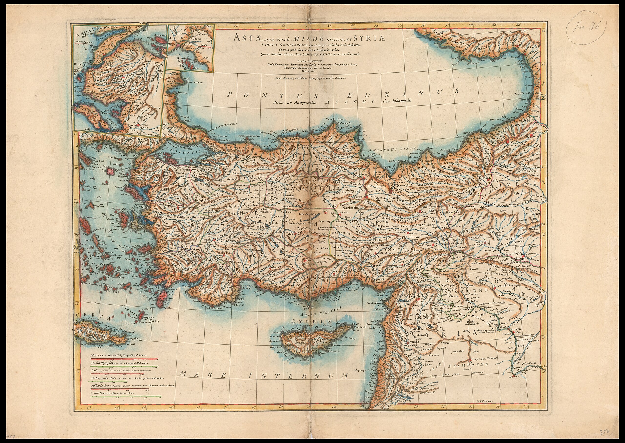
File:Jean Baptiste Bourguignon d'Anville, Asiae Quae Vulgò Minor Dicitur, Et Syriae Tabula Geographica (FL35866812 2626964).jpg
קפיצה לניווט
קפיצה לחיפוש

גודל התצוגה המקדימה הזאת: 800 × 567 פיקסלים. רזולוציות אחרות: 320 × 227 פיקסלים | 640 × 454 פיקסלים | 1,024 × 726 פיקסלים | 1,280 × 908 פיקסלים | 2,560 × 1,815 פיקסלים | 19,120 × 13,556 פיקסלים.
לקובץ המקורי (19,120 × 13,556 פיקסלים, גודל הקובץ: 378.31 מ"ב, סוג MIME: image/jpeg)
כיתובים
כיתובים
נא להוסיף משפט שמסביר מה הקובץ מייצג
תקציר
[עריכה]| Jean Baptiste Bourguignon d'Anville: Asiae Quae Vulgò Minor Dicitur, Et Syriae Tabula Geographica
( |
||||||||||||||||||||||||
|---|---|---|---|---|---|---|---|---|---|---|---|---|---|---|---|---|---|---|---|---|---|---|---|---|
| אומן |
| |||||||||||||||||||||||
| יוצרים נוספים | Haye, G. de la | |||||||||||||||||||||||
| כותרת |
Asiae Quae Vulgò Minor Dicitur, Et Syriae Tabula Geographica |
|||||||||||||||||||||||
| מפרסם |
Auctor |
|||||||||||||||||||||||
| תיאור |
Asiae Quae Vulgò Minor Dicitur, Et Syriae Tabula Geographica. quantùm per subsidia licuit elaborata, Opere, si quod aliud in antiquâ Geographiâ, arduo. Quam Tabulam Clariss. Dom. Comes De Caylus in aere incidi curavit. Auctor D'Anville. Guill. De-la-Haye. |
|||||||||||||||||||||||
| שפה | לטינית | |||||||||||||||||||||||
| תאריך הוצאה לאור | 1764 | |||||||||||||||||||||||
| טכניקה | 1 map : col ; | |||||||||||||||||||||||
| ממדים | 50 × 61 ס"מ | |||||||||||||||||||||||
| אוסף |
|
|||||||||||||||||||||||
| מיקום נוכחי |
|
|||||||||||||||||||||||
| מיקום הוצאה | פריז | |||||||||||||||||||||||
| חיפוש בקטלוג מרחב | פריז | |||||||||||||||||||||||
| הערות | 2 insets on top left | |||||||||||||||||||||||
| IE PID | IE35866810 | |||||||||||||||||||||||
| רוזטה שם קובץ | FL35866812 | |||||||||||||||||||||||
| מזהה רשומה בספרייה הלאומית (P3959) | 990026269640205171 | |||||||||||||||||||||||
| חיפוש בקטלוג מרחב | לטינית, Jean Baptiste Bourguignon d'Anville | |||||||||||||||||||||||
| חיפוש בקטלוג מרחב | Auctor | |||||||||||||||||||||||
| מקור/צלם |
|
|||||||||||||||||||||||
| גרסאות אחרות | ||||||||||||||||||||||||
| Jpg / Tif version |
|
|||||||||||||||||||||||


.jpg)

.jpg&action=edit§ion=1)
רישיון
[עריכה].jpg&action=edit§ion=2)
The copyright situation of this work is theoretically uncertain, because in the country of origin copyright lasts 70 years after the death of the author, and the date of the author's death is unknown. However, the date of creation of the work was over 120 years ago, and it is thus a reasonable assumption that the copyright has expired (see here for the community discussion). Do not use this template if the date of death of the author is known.
| |
| הקובץ הזה זוהה כקובץ חופשי מכל מגבלה ידועה תחת חוק זכויות היוצרים, כולל כל הזכויות הקשורות והסמוכות. | |
היסטוריית הקובץ
ניתן ללחוץ על תאריך/שעה כדי לראות את הקובץ כפי שנראה באותו זמן.
| תאריך/שעה | תמונה ממוזערת | ממדים | משתמש | הערה | |
|---|---|---|---|---|---|
| נוכחית | 01:48, 23 באוגוסט 2023 | | 13,556 × 19,120 (378.31 מ"ב) | Geagea (שיחה | תרומות) | pattypan 22.03 |
אין באפשרותך לדרוס את הקובץ הזה.
שימוש בקובץ
הדף הבא משתמש בקובץ הזה:
.jpg&oldid=795225337)