File:Jewish Agency for Israel, בדיקת קרקעות המפה המשולשת 05-soil-types (FL42747592 2367512).jpg
קפיצה לניווט
קפיצה לחיפוש

גודל התצוגה המקדימה הזאת: 369 × 599 פיקסלים. רזולוציות אחרות: 148 × 240 פיקסלים | 295 × 480 פיקסלים | 473 × 768 פיקסלים | 630 × 1,024 פיקסלים | 1,261 × 2,048 פיקסלים | 11,934 × 19,379 פיקסלים.
לקובץ המקורי (11,934 × 19,379 פיקסלים, גודל הקובץ: 285.02 מ"ב, סוג MIME: image/jpeg)
כיתובים
כיתובים
נא להוסיף משפט שמסביר מה הקובץ מייצג
תקציר
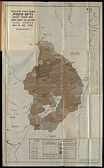
[עריכה]| בדיקת קרקעות המפה המשולשת
( |
||||||||||||||||||||||||
|---|---|---|---|---|---|---|---|---|---|---|---|---|---|---|---|---|---|---|---|---|---|---|---|---|
| אומן |
|
|||||||||||||||||||||||
| כותרת |
בדיקת קרקעות המפה המשולשת |
|||||||||||||||||||||||
| תיאור |
בדיקת קרקעות המפה המשולשת. אזור החולה.. |
|||||||||||||||||||||||
| שפה | עברית, אנגלית | |||||||||||||||||||||||
| תאריך הוצאה לאור | 1947 | |||||||||||||||||||||||
| אוסף |
|
|||||||||||||||||||||||
| מיקום נוכחי |
|
|||||||||||||||||||||||
| הערות | סקר קרקעות באזור החולה / חולה | |||||||||||||||||||||||
| IE PID | IE42747576 | |||||||||||||||||||||||
| רוזטה שם קובץ | FL42747592 | |||||||||||||||||||||||
| מזהה רשומה בספרייה הלאומית (P3959) | 990023675120205171 | |||||||||||||||||||||||
| מוצג | ימת החולה – אגם בישראל | |||||||||||||||||||||||
| חיפוש בקטלוג מרחב | ימת החולה, עברית, אנגלית, הסוכנות היהודית | |||||||||||||||||||||||
| חיפוש בקטלוג מרחב | Soil Surveyמים היגרוסקופייםמפת טיפוסי הקרקעשעור הגיר באדמהעומק הקרקעSoilsEretz IsraelMaps | |||||||||||||||||||||||
| מקור/צלם |
|
|||||||||||||||||||||||
| גרסאות אחרות | ||||||||||||||||||||||||
| Jpg / Tif version |
|
|||||||||||||||||||||||


.jpg)

.jpg&action=edit§ion=1)
רישיון
[עריכה].jpg&action=edit§ion=2)
This UK artistic or literary work, of which the author is unknown and cannot be ascertained by reasonable enquiry, is in the public domain because it is one of the following:
|
 |
היסטוריית הקובץ
ניתן ללחוץ על תאריך/שעה כדי לראות את הקובץ כפי שנראה באותו זמן.
| תאריך/שעה | תמונה ממוזערת | ממדים | משתמש | הערה | |
|---|---|---|---|---|---|
| נוכחית | 18:32, 1 בספטמבר 2023 | | 19,379 × 11,934 (285.02 מ"ב) | Geagea (שיחה | תרומות) | pattypan 22.03 |
אין באפשרותך לדרוס את הקובץ הזה.
שימוש בקובץ
הדף הבא משתמש בקובץ הזה:
.jpg&oldid=798034202)