File:John Harris, A map of the fourty years travels of the Israelites out of Egypt through the Red Sea & the wilderness into the Land of Promise (FL69134069 2368603).jpg
קפיצה לניווט
קפיצה לחיפוש

גודל התצוגה המקדימה הזאת: 800 × 509 פיקסלים. רזולוציות אחרות: 320 × 204 פיקסלים | 640 × 407 פיקסלים | 1,024 × 652 פיקסלים | 1,280 × 815 פיקסלים | 2,560 × 1,629 פיקסלים | 11,978 × 7,622 פיקסלים.
לקובץ המקורי (11,978 × 7,622 פיקסלים, גודל הקובץ: 133.82 מ"ב, סוג MIME: image/jpeg)
כיתובים
כיתובים
נא להוסיף משפט שמסביר מה הקובץ מייצג
תקציר
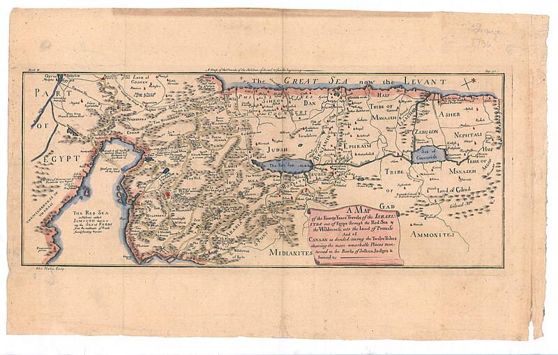
[עריכה]| John Harris: A map of the fourty years travels of the Israelites out of Egypt through the Red Sea & the wilderness into the Land of Promise
( |
||||||||||||||||||||||||
|---|---|---|---|---|---|---|---|---|---|---|---|---|---|---|---|---|---|---|---|---|---|---|---|---|
| אומן | ||||||||||||||||||||||||
| כותרת |
A map of the fourty years travels of the Israelites out of Egypt through the Red Sea & the wilderness into the Land of Promise |
|||||||||||||||||||||||
| תיאור |
A map of the fourty years travels of the Israelites out of Egypt through the Red Sea & the wilderness into the Land of Promise. And of Canaan as divided among the Twelve Tribes shewing the more remarkable in the Books of Joshua Judges & Samuel & c . I.Harris Sculp. |
|||||||||||||||||||||||
| שפה | אנגלית | |||||||||||||||||||||||
| תאריך הוצאה לאור | 1720 ייתכן | |||||||||||||||||||||||
| ממדים | 178 × 430 מ"מ | |||||||||||||||||||||||
| אוסף |
|
|||||||||||||||||||||||
| מיקום נוכחי |
|
|||||||||||||||||||||||
| מיקום הוצאה | לונדון | |||||||||||||||||||||||
| חיפוש בקטלוג מרחב | לונדון | |||||||||||||||||||||||
| הערות | Copperplat; Probably from an English Bible, published in 18th century. Book III, p.91. The map is drawn after Visscher | |||||||||||||||||||||||
| IE PID | IE69134067 | |||||||||||||||||||||||
| רוזטה שם קובץ | FL69134069 | |||||||||||||||||||||||
| מזהה רשומה בספרייה הלאומית (P3959) | 990023686030205171 | |||||||||||||||||||||||
| חיפוש בקטלוג מרחב | אנגלית, John Harris | |||||||||||||||||||||||
| חיפוש בקטלוג מרחב | Exodus, TheITwelve tribes of IsraelMaps | |||||||||||||||||||||||
| מקור/צלם |
|
|||||||||||||||||||||||
| גרסאות אחרות | ||||||||||||||||||||||||
| Jpg / Tif version |
|
|||||||||||||||||||||||

.jpg)

.jpg&action=edit§ion=1)
רישיון
[עריכה].jpg&action=edit§ion=2)
The copyright situation of this work is theoretically uncertain, because in the country of origin copyright lasts 70 years after the death of the author, and the date of the author's death is unknown. However, the date of creation of the work was over 120 years ago, and it is thus a reasonable assumption that the copyright has expired (see here for the community discussion). Do not use this template if the date of death of the author is known.
| |
| הקובץ הזה זוהה כקובץ חופשי מכל מגבלה ידועה תחת חוק זכויות היוצרים, כולל כל הזכויות הקשורות והסמוכות. | |
היסטוריית הקובץ
ניתן ללחוץ על תאריך/שעה כדי לראות את הקובץ כפי שנראה באותו זמן.
| תאריך/שעה | תמונה ממוזערת | ממדים | משתמש | הערה | |
|---|---|---|---|---|---|
| נוכחית | 13:46, 28 ביולי 2023 | | 7,622 × 11,978 (133.82 מ"ב) | Geagea (שיחה | תרומות) | pattypan 22.03 |
אין באפשרותך לדרוס את הקובץ הזה.
שימוש בקובץ
הדף הבא משתמש בקובץ הזה:
.jpg&oldid=787624977)