File:John Speed, A Newe Mape Of Tartary (FL36380609 2614554).jpg
קפיצה לניווט
קפיצה לחיפוש

גודל התצוגה המקדימה הזאת: 788 × 599 פיקסלים. רזולוציות אחרות: 316 × 240 פיקסלים | 631 × 480 פיקסלים | 1,010 × 768 פיקסלים | 1,280 × 974 פיקסלים | 2,560 × 1,947 פיקסלים | 12,866 × 9,786 פיקסלים.
לקובץ המקורי (12,866 × 9,786 פיקסלים, גודל הקובץ: 194.45 מ"ב, סוג MIME: image/jpeg)
כיתובים
כיתובים
נא להוסיף משפט שמסביר מה הקובץ מייצג
תקציר
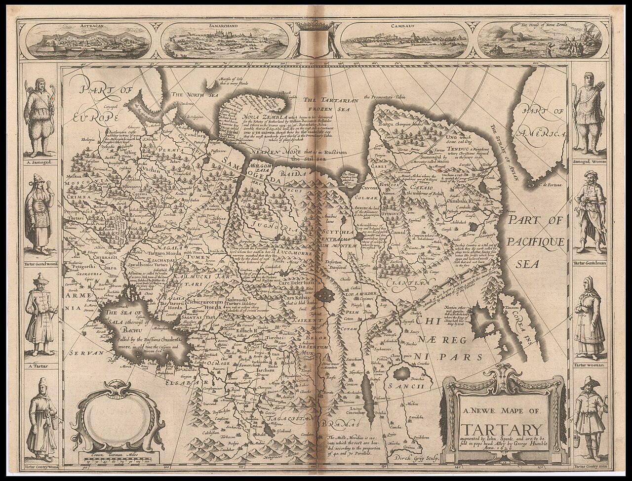
[עריכה]| ג'ון ספיד: A Newe Mape Of Tartary
( |
||||||||||||||||||||||||
|---|---|---|---|---|---|---|---|---|---|---|---|---|---|---|---|---|---|---|---|---|---|---|---|---|
| אומן |
| |||||||||||||||||||||||
| יוצרים נוספים | Humble, George, -1640 Gryp, Dirck | |||||||||||||||||||||||
| כותרת |
A Newe Mape Of Tartary |
|||||||||||||||||||||||
| מפרסם |
George Humble should be: William Humble |
|||||||||||||||||||||||
| תיאור |
A Newe Mape Of Tartary. augmented by Iohn Speede. Dirck Grÿp Sculp. |
|||||||||||||||||||||||
| שפה | אנגלית | |||||||||||||||||||||||
| תאריך הוצאה לאור | 1626 | |||||||||||||||||||||||
| טכניקה | 1 sheet ; | |||||||||||||||||||||||
| ממדים | גובה: 407 מ"מ; רוחב: 530 מ"מ | |||||||||||||||||||||||
| אוסף |
|
|||||||||||||||||||||||
| מיקום נוכחי |
|
|||||||||||||||||||||||
| מיקום הוצאה | לונדון | |||||||||||||||||||||||
| חיפוש בקטלוג מרחב | לונדון | |||||||||||||||||||||||
| הערות | 4 views above the map: Astracan. Samarchand. Cambalu. The House of Nova Zemla; On both sides of map people in different costumes; On verso text in English, The description of the kingdome of Tartary, pp.39-40. | |||||||||||||||||||||||
| IE PID | IE36380607 | |||||||||||||||||||||||
| רוזטה שם קובץ | FL36380609 | |||||||||||||||||||||||
| מזהה רשומה בספרייה הלאומית (P3959) | 990026145540205171 | |||||||||||||||||||||||
| חיפוש בקטלוג מרחב | אנגלית, ג'ון ספיד | |||||||||||||||||||||||
| חיפוש בקטלוג מרחב | TatarsMapsGeorge Humble should be: William Humble | |||||||||||||||||||||||
| מקור/צלם |
|
|||||||||||||||||||||||
| גרסאות אחרות | ||||||||||||||||||||||||
| Jpg / Tif version |
|
|||||||||||||||||||||||


.jpg)

.jpg&action=edit§ion=1)
רישיון
[עריכה].jpg&action=edit§ion=2)
The copyright situation of this work is theoretically uncertain, because in the country of origin copyright lasts 70 years after the death of the author, and the date of the author's death is unknown. However, the date of creation of the work was over 120 years ago, and it is thus a reasonable assumption that the copyright has expired (see here for the community discussion). Do not use this template if the date of death of the author is known.
| |
| הקובץ הזה זוהה כקובץ חופשי מכל מגבלה ידועה תחת חוק זכויות היוצרים, כולל כל הזכויות הקשורות והסמוכות. | |
היסטוריית הקובץ
ניתן ללחוץ על תאריך/שעה כדי לראות את הקובץ כפי שנראה באותו זמן.
| תאריך/שעה | תמונה ממוזערת | ממדים | משתמש | הערה | |
|---|---|---|---|---|---|
| נוכחית | 04:01, 28 באוגוסט 2023 | | 9,786 × 12,866 (194.45 מ"ב) | Geagea (שיחה | תרומות) | pattypan 22.03 |
אין באפשרותך לדרוס את הקובץ הזה.
שימוש בקובץ
הדף הבא משתמש בקובץ הזה:
.jpg&oldid=796861864)