File:Joris Hoefnagel, Sinus Gaditanus, nunc Baia de Cadiz (FL60504915 2588930).jpg
קפיצה לניווט
קפיצה לחיפוש

גודל התצוגה המקדימה הזאת: 716 × 600 פיקסלים. רזולוציות אחרות: 287 × 240 פיקסלים | 573 × 480 פיקסלים | 917 × 768 פיקסלים | 1,223 × 1,024 פיקסלים | 2,446 × 2,048 פיקסלים | 14,974 × 12,538 פיקסלים.
לקובץ המקורי (14,974 × 12,538 פיקסלים, גודל הקובץ: 218.16 מ"ב, סוג MIME: image/jpeg)
כיתובים
כיתובים
נא להוסיף משפט שמסביר מה הקובץ מייצג
תקציר
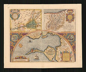
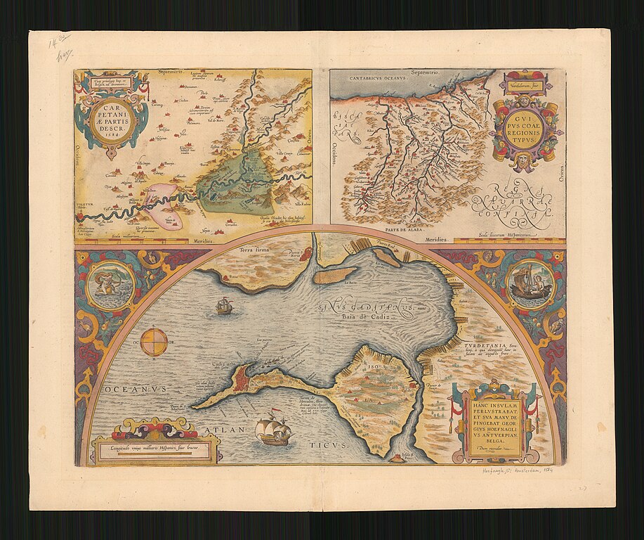
[עריכה]| יוריס הופנגל: Sinus Gaditanus, nunc Baia de Cadiz
( |
||||||||||||||||||||||||
|---|---|---|---|---|---|---|---|---|---|---|---|---|---|---|---|---|---|---|---|---|---|---|---|---|
| אומן |
|
|||||||||||||||||||||||
| כותרת |
Sinus Gaditanus, nunc Baia de Cadiz |
|||||||||||||||||||||||
| תיאור |
Sinus Gaditanus, nunc Baia de Cadiz. Hanc Insulam Perlustrabat, Et Sua Manu Depingebat Georgius Hoefnaglius. |
|||||||||||||||||||||||
| שפה | לטינית | |||||||||||||||||||||||
| תאריך הוצאה לאור | 1584 | |||||||||||||||||||||||
| טכניקה | 3 maps of 1 sheet : col ; | |||||||||||||||||||||||
| ממדים | גובה: 48 ס"מ; רוחב: 58 ס"מ | |||||||||||||||||||||||
| אוסף |
|
|||||||||||||||||||||||
| מיקום נוכחי |
|
|||||||||||||||||||||||
| מיקום הוצאה | Antwerp | |||||||||||||||||||||||
| הערות | Text on verso: l'Isola di Cadiz, sotto cadiz par, che Strabone... p.17. | |||||||||||||||||||||||
| IE PID | IE60504913 | |||||||||||||||||||||||
| רוזטה שם קובץ | FL60504915 | |||||||||||||||||||||||
| מזהה רשומה בספרייה הלאומית (P3959) | 990025889300205171 | |||||||||||||||||||||||
| חיפוש בקטלוג מרחב | לטינית, יוריס הופנגל, Antwerp | |||||||||||||||||||||||
| חיפוש בקטלוג מרחב | Guipus Coae Regionis TypusCarpetaniae Partis Descr | |||||||||||||||||||||||
| מקור/צלם |
|
|||||||||||||||||||||||
| גרסאות אחרות | ||||||||||||||||||||||||
| Jpg / Tif version |
|
|||||||||||||||||||||||
_-_Portrait_of_Joris_Hoefnagel.jpg)

.jpg)

.jpg&action=edit§ion=1)
רישיון
[עריכה].jpg&action=edit§ion=2)
The copyright situation of this work is theoretically uncertain, because in the country of origin copyright lasts 70 years after the death of the author, and the date of the author's death is unknown. However, the date of creation of the work was over 120 years ago, and it is thus a reasonable assumption that the copyright has expired (see here for the community discussion). Do not use this template if the date of death of the author is known.
| |
| הקובץ הזה זוהה כקובץ חופשי מכל מגבלה ידועה תחת חוק זכויות היוצרים, כולל כל הזכויות הקשורות והסמוכות. | |
היסטוריית הקובץ
ניתן ללחוץ על תאריך/שעה כדי לראות את הקובץ כפי שנראה באותו זמן.
| תאריך/שעה | תמונה ממוזערת | ממדים | משתמש | הערה | |
|---|---|---|---|---|---|
| נוכחית | 22:03, 1 באוגוסט 2023 | | 12,538 × 14,974 (218.16 מ"ב) | Geagea (שיחה | תרומות) | c:User:Rillke/bigChunkedUpload.js: =={{int:filedesc}}== {{Artwork |artist = {{Creator|wikidata=Q1388840}} |author = |title = Sinus Gaditanus, nunc Baia de Cadiz |description = Sinus Gaditanus, nunc Baia de Cadiz. Hanc Insulam Perlustrabat, Et Sua Manu Depingebat Georgius Hoefnaglius. |language = {{Label|1=Q397}} |date = |publication date = 1584 |medium = 3 maps of 1 sheet : col ; |dimensions = {{size|cm|48|58}} |institution = {{Institution:Eran Laor Cartographic Collection}}... |
אין באפשרותך לדרוס את הקובץ הזה.
שימוש בקובץ
הדפים הבאים משתמשים בקובץ הזה:
.jpg&oldid=789128180)