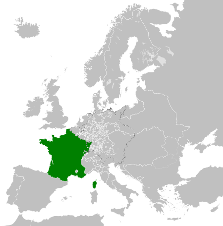
File:Kingdom of France (1789).svg
둘러보기로 이동
검색으로 이동

SVG 파일의 PNG 형식의 미리보기 크기: 450 × 456 픽셀. 다른 해상도: 237 × 240 픽셀 | 474 × 480 픽셀 | 758 × 768 픽셀 | 1,011 × 1,024 픽셀 | 2,021 × 2,048 픽셀
원본 파일 (SVG 파일, 실제 크기 450 × 456 픽셀, 파일 크기: 911 KB)
캡션
설명
이 파일이 나타내는 바에 대한 한 줄 설명을 추가합니다
파일 설명[편집]


.svg)
.svg)
.svg)
.svg)
.svg)


.svg)
.svg)
.svg)


.png)
.png)


.svg)


.svg)

.svg)


.svg)
.svg)
.svg)
.svg)


.svg)
.png)


.svg)


.svg)
.svg)


.svg)


.svg)


.svg&action=edit§ion=1)
.svg)
.svg)
.svg)
.svg)
.svg)
.svg)
.svg)
_cropped.svg)
.svg)
.svg)
.svg)
.svg)
.svg)
.svg)
.svg)
.svg)
.svg)
.svg)
.svg)
.svg)
.svg)
.svg)
.svg)
.svg)
.svg)
.svg)
.svg)
.svg)
.svg)
.svg)
.svg)
.svg)
.svg)
.svg)
.svg)
.svg)
.svg)
.svg)
.svg)
.svg)
.svg)
.svg)
.svg)
.svg)
.svg)
.svg)
.svg)
.svg)
.svg)
.svg)
.svg)
.svg)
.svg)
파일 역사
날짜/시간 링크를 클릭하면 해당 시간의 파일을 볼 수 있습니다.
| 날짜/시간 | 섬네일 | 크기 | 사용자 | 설명 | |
|---|---|---|---|---|---|
| 현재 | 2021년 10월 17일 (일) 08:12 | | 450 × 456 (911 KB) | Fenn-O-maniC (토론 | 기여) | Fixed the Russo-Swedish border to match the Treaty of Åbo of 1743 |
| 2017년 12월 29일 (금) 06:36 |  | 450 × 456 (914 KB) | TRAJAN 117 (토론 | 기여) | Update | |
| 2017년 12월 25일 (월) 01:55 |  | 450 × 456 (832 KB) | TRAJAN 117 (토론 | 기여) | +++ | |
| 2013년 8월 27일 (화) 02:14 |  | 450 × 456 (802 KB) | TRAJAN 117 (토론 | 기여) | +++ | |
| 2013년 5월 7일 (화) 21:52 |  | 450 × 456 (839 KB) | TRAJAN 117 (토론 | 기여) | {{Information |Description ={{en|1=The Kingdom of France in 1789.}} |Source ={{own}} {{AttribSVG|Europe 1789.svg|Alphathon}} |Author =TRAJAN 117 {{created with Inkscape}} |Date =2013-05-07 |Permission ... |
이 파일을 덮어쓸 수 없습니다.
이 파일을 사용하는 문서
100개 이상의 문서가 이 파일을 사용하고 있습니다. 다음 목록은 이 파일을 사용하는 처음 문서 100개만 보여주고 있습니다. 이 파일을 사용하는 모든 문서 목록을 볼 수 있습니다.
.svg)
- User:Alphathon/Historical Europe
- File:Albania 1956-1990.svg
- File:Albanian Kingdom (1935).svg
- File:Albanian Kingdom (1939).svg
- File:Austrian Lombardy 1789.svg
- File:Austrian Netherlands 1789.svg
- File:Austro-Hungarian Monarchy (1914).svg
- File:Blank map of Europe 1812.svg
- File:Blank map of Europe 1890.svg
- File:Blank map of Europe 1914.svg
- File:Blank map of Europe 1929-1938.svg
- File:Blank map of Europe 1956-1990.svg
- File:Blank map of Europe October 1938 - March 1939.svg
- File:Bulgaria 1956-1990.svg
- File:Confederation of the Rhine (1812).svg
- File:Cortina di ferro.png
- File:Czechoslovak Republic (1938).svg
- File:Czechoslovak Republic (1939).svg
- File:Czechoslovakia 1956–1990.svg
- File:Duchy of Holstein 1789.svg
- File:Duchy of Mecklenburg-Schwerin 1789.svg
- File:Duchy of Warsaw (1812).svg
- File:Duchy of Württemberg 1789.svg
- File:East Germany 1956-1990.svg
- File:Ecclesiastical lands of the Holy Roman Empire 1789.svg
- File:Electorate of Bavaria 1789.svg
- File:Electorate of Brunswick-Lüneburg 1789.svg
- File:Electorate of Saxony 1789.svg
- File:Europe 1789.svg
- File:Europe 1942.svg
- File:First French Empire 1812.svg
- File:Free City Danzig 1930.svg
- File:Free City of Danzig (1812).svg
- File:French Empire (1812).svg
- File:French State (1942).svg
- File:General Government (1942).svg
- File:German Empire 1914.svg
- File:German Reich (1939).svg
- File:Grand Duchy of Tuscany 1789.svg
- File:Grand Principality of Finland (1914).svg
- File:Greater German Reich (1942).svg
- File:Habsburg Monarchy 1789.svg
- File:Hellenic Republic (1935).svg
- File:Hungary 1956-1990.svg
- File:Imperial Italy.png
- File:InterwarCentralEurope.png
- File:Kingdom of Bulgaria (1914).svg
- File:Kingdom of France (1789).svg
- File:Kingdom of Greece (1890).svg
- File:Kingdom of Greece (1914).svg
- File:Kingdom of Greece (1973).svg
- File:Kingdom of Hungary (1942).svg
- File:Kingdom of Italy (1936).svg
- File:Kingdom of Italy (Napoleonic).svg
- File:Kingdom of Montenegro (1914).svg
- File:Kingdom of Portugal (1890).svg
- File:Kingdom of Prussia 1789.svg
- File:Kingdom of Romania (1890).svg
- File:Kingdom of Romania (1914).svg
- File:Kingdom of Romania (1939).svg
- File:Kingdom of Sardinia 1789.svg
- File:Kingdom of Serbia (1890).svg
- File:Kingdom of Serbia (1914).svg
- File:Kingdom of Spain (1789).svg
- File:Landgraviate of Hesse-Kassel 1789.svg
- File:Location Moldavian Democratic Republic.png
- File:Map Holy Roman Empire 1789.svg
- File:Map of the Republic of Serbia (2006–2008).svg
- File:Maps of Yugoslavia and FR Yugoslavia.svg
- File:Military Administration in Belgium and Northern France (1942).svg
- File:Military Administration in France (1942).svg
- File:Papal States 1789.svg
- File:Poland 1930.svg
- File:Poland 1956-1990.svg
- File:Polish-Lithuanian Commonwealth 1789.svg
- File:Prince-Bishopric of Montenegro (1812).svg
- File:Principality of Albania (1914).svg
- File:Principality of Bulgaria (1890).svg
- File:Principality of Montenegro (1890).svg
- File:Protectorate of Bohemia and Moravia (1942).svg
- File:Reichskommissariat Niederlande (1942).svg
- File:Reichskommissariat Norwegen (1942).svg
- File:Reichskommissariat Ostland (1942).svg
- File:Reichskommissariat Ukraine (1942).svg
- File:Republic of Genoa 1789.svg
- File:Republic of Montenegro (2006).svg
- File:Republic of Venice 1789.svg
- File:Republic of the Seven United Netherlands (1789).svg
- File:Romania 1956-1990.svg
- File:Serbia 1942.svg
- File:Slovak Republic (1942).svg
- File:Spanish Republic (1936).svg
- File:Spanish State (1975).svg
- File:Sweden 1789.svg
- File:Territory of the Serbian Uprising (1812).svg
- File:Voivodeship of Moldavia (1812).svg
- File:Voivodeship of Wallachia (1812).svg
- File:Weimar Republic 1930.svg
- File:West Germany 1956-1990.svg
- File:Yugoslavia 1956-1990.svg
.svg)
.svg)
.svg)
.svg)
이 파일이 쓰이고 있는 문서 목록 더 보기.
이 파일을 사용하고 있는 모든 위키의 문서 목록
다음 위키에서 이 파일을 사용하고 있습니다:
- ar.wikipedia.org에서 이 파일을 사용하고 있는 문서 목록
- arz.wikipedia.org에서 이 파일을 사용하고 있는 문서 목록
- ast.wikipedia.org에서 이 파일을 사용하고 있는 문서 목록
- az.wikipedia.org에서 이 파일을 사용하고 있는 문서 목록
- be.wikipedia.org에서 이 파일을 사용하고 있는 문서 목록
- bg.wikipedia.org에서 이 파일을 사용하고 있는 문서 목록
- cs.wikipedia.org에서 이 파일을 사용하고 있는 문서 목록
- da.wikipedia.org에서 이 파일을 사용하고 있는 문서 목록
- de.wikipedia.org에서 이 파일을 사용하고 있는 문서 목록
- el.wikipedia.org에서 이 파일을 사용하고 있는 문서 목록
- en.wikipedia.org에서 이 파일을 사용하고 있는 문서 목록
- es.wikipedia.org에서 이 파일을 사용하고 있는 문서 목록
- fa.wikipedia.org에서 이 파일을 사용하고 있는 문서 목록
- fi.wikipedia.org에서 이 파일을 사용하고 있는 문서 목록
- fr.wikipedia.org에서 이 파일을 사용하고 있는 문서 목록
- ga.wikipedia.org에서 이 파일을 사용하고 있는 문서 목록
- gl.wikipedia.org에서 이 파일을 사용하고 있는 문서 목록
- he.wikipedia.org에서 이 파일을 사용하고 있는 문서 목록
- hr.wikipedia.org에서 이 파일을 사용하고 있는 문서 목록
- hu.wikipedia.org에서 이 파일을 사용하고 있는 문서 목록
- id.wikipedia.org에서 이 파일을 사용하고 있는 문서 목록
- incubator.wikimedia.org에서 이 파일을 사용하고 있는 문서 목록
- is.wikipedia.org에서 이 파일을 사용하고 있는 문서 목록
- it.wikipedia.org에서 이 파일을 사용하고 있는 문서 목록
- ja.wikipedia.org에서 이 파일을 사용하고 있는 문서 목록
- ka.wikipedia.org에서 이 파일을 사용하고 있는 문서 목록
- ko.wikipedia.org에서 이 파일을 사용하고 있는 문서 목록
- lfn.wikipedia.org에서 이 파일을 사용하고 있는 문서 목록
- lmo.wikipedia.org에서 이 파일을 사용하고 있는 문서 목록
- lt.wikipedia.org에서 이 파일을 사용하고 있는 문서 목록
- lv.wikipedia.org에서 이 파일을 사용하고 있는 문서 목록
- ms.wikipedia.org에서 이 파일을 사용하고 있는 문서 목록
- no.wikipedia.org에서 이 파일을 사용하고 있는 문서 목록
이 파일의 더 많은 사용 내역을 봅니다.
.svg)
.svg&oldid=754000456)