File:Kingdom of Hungary counties.svg
קפיצה לניווט
קפיצה לחיפוש

גודל התצוגה המקדימה הזאת מסוג PNG של קובץ ה־SVG הזה: 779 × 513 פיקסלים. רזולוציות אחרות: 320 × 211 פיקסלים | 640 × 421 פיקסלים | 1,024 × 674 פיקסלים | 1,280 × 843 פיקסלים | 2,560 × 1,686 פיקסלים.
לקובץ המקורי (קובץ SVG, הגודל המקורי: 779 × 513 פיקסלים, גודל הקובץ: 235 ק"ב)
כיתובים
כיתובים
נא להוסיף משפט שמסביר מה הקובץ מייצג
תקציר
[עריכה]
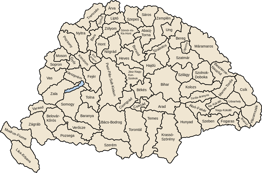
| תיאור | Map of counties of Kingdom of Hungary (Hungary proper and Croatia & Slavonia), 1886-1918 |
| תאריך יצירה | |
| מקור | נוצר על־ידי מעלה היצירה |
| יוצר | User:IMeowbot |
| גרסאות אחרות | Derivative works of this file: Kingdom of Hungary counties-2.svg |
| SVG development | W3C-validity not checked. |
רישיון
[עריכה]
| ברצוני, בעלי זכויות היוצרים על יצירה זו, לשחרר יצירה זו לנחלת הכלל. זה תקף בכל העולם. יש מדינות שבהן הדבר אינו אפשרי על פי חוק, אם כך: אני מעניק לכל אחד את הזכות להשתמש בעבודה זו לכל מטרה שהיא, ללא תנאים כלשהם, אלא אם כן תנאים כאלה נדרשים על פי חוק. |
היסטוריית הקובץ
ניתן ללחוץ על תאריך/שעה כדי לראות את הקובץ כפי שנראה באותו זמן.
| תאריך/שעה | תמונה ממוזערת | ממדים | משתמש | הערה | |
|---|---|---|---|---|---|
| נוכחית | 07:41, 19 ביולי 2023 | | 513 × 779 (235 ק"ב) | Alphathon (שיחה | תרומות) | Reverted to version as of 22:47, 16 August 2022 (UTC). Bars/Hont and Csongrád/Bács-Bodrog borders are inaccurate, several more are distored (most only slightly) and the file is a "FakeSVG" – a raster image using an SVG as a container with no actual vector elements. |
| 22:43, 20 בינואר 2023 |  | 5,472 × 8,277 (589 ק"ב) | Ascended Dreamer (שיחה | תרומות) | Added FIume and increased line weight | |
| 22:31, 20 בינואר 2023 |  | 5,472 × 8,277 (607 ק"ב) | Ascended Dreamer (שיחה | תרומות) | Increased border accuracy | |
| 22:47, 16 באוגוסט 2022 |  | 513 × 779 (235 ק"ב) | Alphathon (שיחה | תרומות) | corrected õ → ő (tilde → double accute) | |
| 17:53, 5 בדצמבר 2009 |  | 513 × 779 (235 ק"ב) | SimonTrew (שיחה | תרומות) | Fix spelling error Veszprém. | |
| 14:24, 3 בדצמבר 2009 |  | 513 × 779 (235 ק"ב) | SimonTrew (שיחה | תרומות) | Fixed spelling of "Poszsony" -> "Pozsony". | |
| 20:25, 20 באוגוסט 2007 |  | 513 × 779 (235 ק"ב) | Xavax (שיחה | תרומות) | == Summary == {{Information| |Description= Map of counties of Hungary with Croatia & Slavonia, 1886-1918 |Source=own drawing |Date=April 30, 2006 |Author=User:IMeowbot |Permission= |other_versions= }} == Licensing == {{PD-self}} <!--Categories--> [[ | |
| 22:10, 30 באפריל 2006 |  | 513 × 779 (223 ק"ב) | IMeowbot~commonswiki (שיחה | תרומות) | line weight | |
| 21:34, 30 באפריל 2006 |  | 513 × 779 (221 ק"ב) | IMeowbot~commonswiki (שיחה | תרומות) | ||
| 18:34, 30 באפריל 2006 |  | 513 × 779 (195 ק"ב) | IMeowbot~commonswiki (שיחה | תרומות) | {{Information| |Description= Map of late 1870s Hungary counties |Source=own drawing |Date=April 30, 2006 |Author=User:IMeowbot |Permission= |other_versions= }} |
אין באפשרותך לדרוס את הקובץ הזה.
שימוש בקובץ
הדפים הבאים משתמשים בקובץ הזה:
- Atlas of Croatia
- Atlas of Hungary
- Atlas of Slovakia
- Atlas of Székely Land
- Magyarország
- File:Historic counties of Hungary.png
- File:Kingdom of Hungary counties-2.svg
- File:Kingdom of Hungary counties (sk).svg
- File:Kingdom of Hungary counties (sk-Abovsko-turnianska).svg
- File:Kingdom of Hungary counties (sk-Aradská).svg
- File:Kingdom of Hungary counties (sk-Baraňská).svg
- File:Kingdom of Hungary counties (sk-Bihárska).svg
- File:Kingdom of Hungary counties (sk-Bjelovarsko-križevetská).svg
- File:Kingdom of Hungary counties (sk-Boršodská).svg
- File:Kingdom of Hungary counties (sk-Brašovská).svg
- File:Kingdom of Hungary counties (sk-Bystricko-nasodská).svg
- File:Kingdom of Hungary counties (sk-Báčsko-bodrodská).svg
- File:Kingdom of Hungary counties (sk-Dolnobelehradská).svg
- File:Kingdom of Hungary counties (sk-Fogarašská).svg
- File:Kingdom of Hungary counties (sk-Gemersko-malohontská).svg
- File:Kingdom of Hungary counties (sk-Hajducká).svg
- File:Kingdom of Hungary counties (sk-Hevešská).svg
- File:Kingdom of Hungary counties (sk-Hontianska).svg
- File:Kingdom of Hungary counties (sk-Huňadská).svg
- File:Kingdom of Hungary counties (sk-Háromsecká).svg
- File:Kingdom of Hungary counties (sk-Jasovsko-veľkokumánsko-solnocká).svg
- File:Kingdom of Hungary counties (sk-Klužská).svg
- File:Kingdom of Hungary counties (sk-Komárňanská).svg
- File:Kingdom of Hungary counties (sk-Krasovsko-severinská).svg
- File:Kingdom of Hungary counties (sk-Licko-krbavská).svg
- File:Kingdom of Hungary counties (sk-Liptovská).svg
- File:Kingdom of Hungary counties (sk-Malokykulská).svg
- File:Kingdom of Hungary counties (sk-Marmarošská).svg
- File:Kingdom of Hungary counties (sk-Marušsko-turdská).svg
- File:Kingdom of Hungary counties (sk-Modrušsko-skorjecká).svg
- File:Kingdom of Hungary counties (sk-Mošonská).svg
- File:Kingdom of Hungary counties (sk-Čanadská).svg
- File:Kingdom of Hungary counties (sk-Čická).svg
- File:Kingdom of Hungary counties (sk-Čongrádska).svg
- File:Kingdom of Hungary counties 1768x1168.png
.svg)
.svg)
.svg)
.svg)
.svg)
.svg)
.svg)
.svg)
.svg)
.svg)
.svg)
.svg)
.svg)
.svg)
.svg)
.svg)
.svg)
.svg)
.svg)
.svg)
.svg)
.svg)
.svg)
.svg)
.svg)
.svg)
.svg)
.svg)
.svg)
.svg)
.svg)
.svg)
שימוש גלובלי בקובץ
אתרי הוויקי השונים הבאים משתמשים בקובץ זה:
- שימוש באתר als.wikipedia.org
- שימוש באתר an.wikipedia.org
- שימוש באתר ar.wikipedia.org
- שימוש באתר azb.wikipedia.org
- שימוש באתר bg.wikipedia.org
- שימוש באתר bn.wikipedia.org
- שימוש באתר ca.wikipedia.org
- שימוש באתר cs.wikipedia.org
- שימוש באתר cy.wikipedia.org
- שימוש באתר de.wikipedia.org
- שימוש באתר el.wikipedia.org
- שימוש באתר en.wikipedia.org
- Liptó County
- Zemplén County
- Hont County
- Bars County
- Turóc County
- Brassó County
- Bihar County
- Kingdom of Hungary
- Esztergom County
- Pozsony County
- Nyitra County
- Moson County
- Sopron County
- Bács-Bodrog County
- Heves County (former)
- Jász-Nagykun-Szolnok County (former)
- Trencsén County
- Zólyom County
- Pest-Pilis-Solt-Kiskun County
- Komárom County
- Bereg County
- Borsod County
- Ung County
- Hajdú County
- Máramaros County
- Szabolcs County
- Szatmár County
צפייה בשימושים גלובליים נוספים של קובץ זה.