File:Kingdom of Yugoslavia 1930.svg
둘러보기로 이동
검색으로 이동

SVG 파일의 PNG 형식의 미리보기 크기: 450 × 456 픽셀. 다른 해상도: 237 × 240 픽셀 | 474 × 480 픽셀 | 758 × 768 픽셀 | 1,011 × 1,024 픽셀 | 2,021 × 2,048 픽셀
원본 파일 (SVG 파일, 실제 크기 450 × 456 픽셀, 파일 크기: 474 KB)
캡션
설명
이 파일이 나타내는 바에 대한 한 줄 설명을 추가합니다
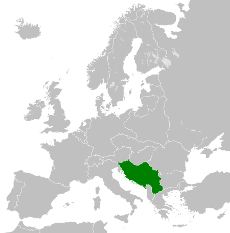
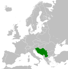
Map of the Kingdom of Yugoslavia in 1930.
| 설명 |
English: Map of the Kingdom of Yugoslavia circa 1930. |
| 날짜 | |
| 출처 | Own work, based upon File:Weimar Republic 1930.svg |
| 저자 | |
| 저작권 (이 파일을 인용하기) |
이 파일은 크리에이티브 커먼즈 저작자표시-동일조건변경허락 3.0 Unported 라이선스로 배포됩니다.
|
| 주석 | 이 이미지에는 주석이 있습니다: 공용에서 주석을 보기 |
파일 역사
날짜/시간 링크를 클릭하면 해당 시간의 파일을 볼 수 있습니다.
| 날짜/시간 | 섬네일 | 크기 | 사용자 | 설명 | |
|---|---|---|---|---|---|
| 현재 | 2013년 8월 12일 (월) 08:09 | | 450 × 456 (474 KB) | Alphathon (토론 | 기여) | Fixed Yugoslav-Hungarian border and Dutch polders (see main file) |
| 2011년 12월 11일 (일) 19:39 |  | 450 × 456 (461 KB) | TRAJAN 117 (토론 | 기여) | {{Information |Description ={{en|1=Map of the Kingdom of Yugoslavia circa 1930.}} |Source =Own work, based upon [http://commons.wikimedia.org/wiki/File:Weimar_Republic_1930.svg] |Author =25px ' |
이 파일을 덮어쓸 수 없습니다.
이 파일을 사용하는 문서
다음 문서 27개가 이 파일을 사용하고 있습니다:
- File:LocationKingdomYugoslavia.PNG
- Category:1918 in Yugoslavia
- Category:1919 in Yugoslavia
- Category:1920 in Yugoslavia
- Category:1921 in Yugoslavia
- Category:1922 in Yugoslavia
- Category:1923 in Yugoslavia
- Category:1926 in Yugoslavia
- Category:1927 in Yugoslavia
- Category:1928 in Yugoslavia
- Category:1929 in Yugoslavia
- Category:1930 in Yugoslavia
- Category:1931 in Yugoslavia
- Category:1932 in Yugoslavia
- Category:1933 in Yugoslavia
- Category:1934 in Yugoslavia
- Category:1935 in Yugoslavia
- Category:1936 in Yugoslavia
- Category:1937 in Yugoslavia
- Category:1938 in Yugoslavia
- Category:1939 in Yugoslavia
- Category:1940 in Yugoslavia
- Category:Kingdom of Serbs, Croats and Slovenes
- Category:Kingdom of Yugoslavia
- Category:Yugoslavia in the 1910s
- Category:Yugoslavia in the 1920s
- Category:Yugoslavia in the 1930s
이 파일을 사용하고 있는 모든 위키의 문서 목록
다음 위키에서 이 파일을 사용하고 있습니다:
- arz.wikipedia.org에서 이 파일을 사용하고 있는 문서 목록
- ast.wikipedia.org에서 이 파일을 사용하고 있는 문서 목록
- azb.wikipedia.org에서 이 파일을 사용하고 있는 문서 목록
- az.wikipedia.org에서 이 파일을 사용하고 있는 문서 목록
- ba.wikipedia.org에서 이 파일을 사용하고 있는 문서 목록
- bg.wikipedia.org에서 이 파일을 사용하고 있는 문서 목록
- bs.wikipedia.org에서 이 파일을 사용하고 있는 문서 목록
- ca.wikipedia.org에서 이 파일을 사용하고 있는 문서 목록
- cs.wikipedia.org에서 이 파일을 사용하고 있는 문서 목록
- da.wikipedia.org에서 이 파일을 사용하고 있는 문서 목록
- de.wikipedia.org에서 이 파일을 사용하고 있는 문서 목록
- el.wikipedia.org에서 이 파일을 사용하고 있는 문서 목록
- en.wikipedia.org에서 이 파일을 사용하고 있는 문서 목록
- Kingdom of Yugoslavia
- 1st Army (Kingdom of Yugoslavia)
- Creation of Yugoslavia
- 1st Army Group (Kingdom of Yugoslavia)
- 2nd Army Group (Kingdom of Yugoslavia)
- 2nd Army (Kingdom of Yugoslavia)
- 4th Army (Kingdom of Yugoslavia)
- 5th Army (Kingdom of Yugoslavia)
- 7th Army (Kingdom of Yugoslavia)
- 42nd Infantry Division Murska
- 40th Infantry Division Slavonska
- 27th Infantry Division Savska
- 32nd Infantry Division Triglavski
- 1st Cavalry Division (Kingdom of Yugoslavia)
- 38th Infantry Division Dravska
- Germany–Yugoslavia relations
- User:Ditto voltorb/sandbox
- User:Falcaorib/Serbia, Yugoslavia and Albania
- en.wiktionary.org에서 이 파일을 사용하고 있는 문서 목록
- eo.wikipedia.org에서 이 파일을 사용하고 있는 문서 목록
- es.wikipedia.org에서 이 파일을 사용하고 있는 문서 목록
- et.wikipedia.org에서 이 파일을 사용하고 있는 문서 목록
- eu.wikipedia.org에서 이 파일을 사용하고 있는 문서 목록
- fa.wikipedia.org에서 이 파일을 사용하고 있는 문서 목록
- fi.wikipedia.org에서 이 파일을 사용하고 있는 문서 목록
- fr.wikipedia.org에서 이 파일을 사용하고 있는 문서 목록
- gl.wikipedia.org에서 이 파일을 사용하고 있는 문서 목록
- he.wikipedia.org에서 이 파일을 사용하고 있는 문서 목록
- hr.wikipedia.org에서 이 파일을 사용하고 있는 문서 목록
- hu.wikipedia.org에서 이 파일을 사용하고 있는 문서 목록
- hy.wikipedia.org에서 이 파일을 사용하고 있는 문서 목록
- id.wikipedia.org에서 이 파일을 사용하고 있는 문서 목록
- it.wikipedia.org에서 이 파일을 사용하고 있는 문서 목록
이 파일의 더 많은 사용 내역을 봅니다.