File:LocationCentralAfricanEmpire.png
둘러보기로 이동
검색으로 이동
최대 해상도입니다.
LocationCentralAfricanEmpire.png (250 × 115 픽셀, 파일 크기: 6 KB, MIME 종류: image/png)
캡션
설명
이 파일이 나타내는 바에 대한 한 줄 설명을 추가합니다

|
이 그림은 벡터 그래픽 버전(SVG)이 있습니다. 래스터(비트맵) 그림 대신 벡터 그래픽 그림을 사용하는 것이 좋습니다.
File:LocationCentralAfricanEmpire.png → File:Central African Empire in its region.svg
|
 |
파일 설명[편집]
| 설명 |
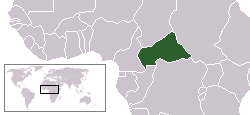
English: Locator map of the former Central African Empire — an autocratic monarchy the existed from 1976 to 1979.
|
| 날짜 | 2007년 7월 27일 (원본 올리기 일시) |
| 출처 | No machine-readable source provided. Own work assumed (based on copyright claims). |
| 저자 | No machine-readable author provided. Hoshie assumed (based on copyright claims). |
라이선스[편집]
| 이 작품은 저작자인 I, Hoshie에 의해 퍼블릭 도메인으로 공개된 작품입니다. 이 공개 선언은 전 세계적으로 유효합니다. 만약 저작권의 포기가 법률적으로 가능하지 않은 경우, I, Hoshie은 이 작품을 법적으로 허용되는 한도 내에서 누구나 자유롭게 어떤 목적으로도 제한 없이 사용할 수 있도록 허용합니다. |
파일 역사
날짜/시간 링크를 클릭하면 해당 시간의 파일을 볼 수 있습니다.
| 날짜/시간 | 섬네일 | 크기 | 사용자 | 설명 | |
|---|---|---|---|---|---|
| 현재 | 2007년 7월 27일 (금) 05:47 | | 250 × 115 (6 KB) | Hoshie (토론 | 기여) | This is a map of the Central African Empire. This map is virtually the same as User:Vardion's location map of the Central African Republic with only two changes. Eritrea and |
이 파일을 덮어쓸 수 없습니다.
이 파일을 사용하는 문서
다음 문서 1개가 이 파일을 사용하고 있습니다: