File:LocationNorthPeru.png
둘러보기로 이동
검색으로 이동
최대 해상도입니다.
LocationNorthPeru.png (250 × 122 픽셀, 파일 크기: 7 KB, MIME 종류: image/png)
캡션
설명
이 파일이 나타내는 바에 대한 한 줄 설명을 추가합니다
파일 설명
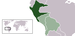
[편집]| 설명 | Location map of the North Peru within the Peru-Bolivian Confederation | ||||||||
| 날짜 | |||||||||
| 출처 | Based on Image:Location ConfederaciónPerú-Boliviana.png | ||||||||
| 저자 | Domino theory | ||||||||
| 저작권 (이 파일을 인용하기) |
나는 아래 작품의 저작권자로서, 이 저작물을 다음과 같은 라이선스로 배포합니다:
이 라이선스 중에서 목적에 맞는 것을 선택하여 사용할 수 있습니다. |
||||||||
| 다른 버전 | Image:LocationSouthPeru.png |

파일 역사
날짜/시간 링크를 클릭하면 해당 시간의 파일을 볼 수 있습니다.
| 날짜/시간 | 섬네일 | 크기 | 사용자 | 설명 | |
|---|---|---|---|---|---|
| 현재 | 2006년 10월 30일 (월) 04:48 | | 250 × 122 (7 KB) | Huhsunqu (토론 | 기여) | |
| 2006년 10월 12일 (목) 14:36 |  | 250 × 122 (7 KB) | Domino theory (토론 | 기여) | *Location map of the the Republic of North Peru within the Peru-Bolivian Confederation. Based on Image:Location ConfederaciónPerú-Boliviana.png Category:Maps of South America Category:Locator maps for former territories |
이 파일을 덮어쓸 수 없습니다.
이 파일을 사용하는 문서
이 파일을 사용하는 문서가 없습니다.