File:Majak Satellitenkarte.jpg
קפיצה לניווט
קפיצה לחיפוש
גודל התצוגה המקדימה הזאת: 800 × 509 פיקסלים. רזולוציות אחרות: 320 × 204 פיקסלים | 640 × 408 פיקסלים | 1,024 × 652 פיקסלים | 1,448 × 922 פיקסלים.
לקובץ המקורי (1,448 × 922 פיקסלים, גודל הקובץ: 292 ק"ב, סוג MIME: image/jpeg)
כיתובים
כיתובים
נא להוסיף משפט שמסביר מה הקובץ מייצג
| תיאור |
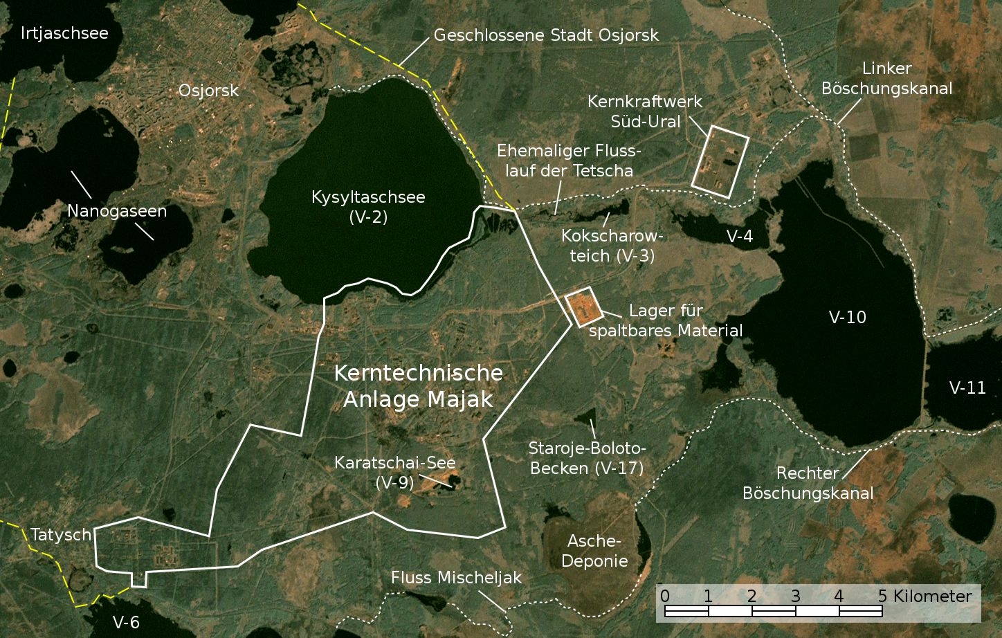
English: Satellite image/map of the Mayak nuclear facility, the closed town of Ozyorsk/Ozersk (Chelyabinsk-65), different lakes and reservoirs, and the South Urals nuclear power plant.
Based on a screenshot from NASA World Wind (Landsat Global Mosaic visual layer), color corrected.
Deutsch: Satellitenfoto/Karte der kerntechnischen Anlage Majak, der geschlossenen Stadt Osjorsk (Tscheljabinsk-65), verschiedenen Seen und Reservoire sowie dem Kernkraftwerk Süd-Ural.
Basierend auf einem Screenshot aus NASA World Wind (Landsat Global Mosaic visual layer), farbkorrigiert. |
|||||
| תאריך יצירה | ||||||
| מקור | NASA World Wind screenshot (Landsat Global Mosaic visual layer) | |||||
| יוצר | NASA, Jan Rieke (color correction, borders and labels) | |||||
| אישורים והיתרים (שימוש חוזר בקובץ זה) |
|
|||||
| גרסאות אחרות | File:Satellite image map of Mayak.jpg |

| זוהי תמונה מרוטשת, זאת אומרת שהתמונה שונתה בצורה דיגיטלית מהמקור. Modifications: Farbkorrektur, Bezeichnungen und Grenzen. השינוי בוצע על ידי JanRieke.
|
| מיקום המצלמה | | תמונה זו ותמונות נוספות במיקום: OpenStreetMap |
|---|
Nennung der Urheber bei Weiterverwendung außerhalb der Wikipedia wäre schön, ist aber nicht erforderlich.
Quellen
[עריכה]
Hauptquellen
[עריכה]
- Igor Kudrik, Aleksandr Nikitin, Charles Digges, Nils Bøhmer, Vladislav Larin, Vladimir Kuznetsov: The Russian Nuclear Industry – The Need for Reform. Bellona Report Volume 4:2004. Bellona Foundation, S. 47–69, 1. November 2004
- Map of the system of dams and drainage channels at Mayak., in: AMAP Assessment Report: Arctic Pollution Issues, Arctic Monitoring & Assessment Programme, Working Group of the Arctic Council, 1998
- Dmitriy Burmistrov, Mira Kossenko, Richard Wilson: Radioactive Contamination of the Techa River and its Effects. archive copy at the Wayback Machine Technology, Vol. 7, S. 553-575, 2000
Weitere Quellen
[עריכה]
Position von V-6
[עריכה]
- B. Gusakov, A. Demin, M. Zawadzki, V. Kalinkin, A. Kirsanov, N. Shafrova: Решение экологических проблем Теченского каскада водоемов на ПО "Маяк"., 19. Dezember 2006
Aschedeponie
[עריכה]
- A. R. Hutter: Radioactive contamination distribution in the bottom sediments and water of the Mishelyak River[dead link], Journal of Radioanalytical and Nuclear Chemistry, 2001
- O. Aleksandrova: Natural remediation of surface water systems used as deposits of nuclear industry waste by humic substances, Dissertation, Universität Osnabrück, 2009
| Annotations | This image is annotated: View the annotations at Commons |
היסטוריית הקובץ
ניתן ללחוץ על תאריך/שעה כדי לראות את הקובץ כפי שנראה באותו זמן.
| תאריך/שעה | תמונה ממוזערת | ממדים | משתמש | הערה | |
|---|---|---|---|---|---|
| נוכחית | 02:48, 28 בנובמבר 2010 | | 922 × 1,448 (292 ק"ב) | JanRieke (שיחה | תרומות) | Yellow color for closed city borders, slightly reduced brightness |
| 00:53, 14 בנובמבר 2010 |  | 922 × 1,448 (282 ק"ב) | JanRieke (שיחה | תרומות) | Included courses of rivers, minor other changes | |
| 23:09, 14 במאי 2010 |  | 922 × 1,448 (276 ק"ב) | JanRieke (שיחה | תרומות) | {{Information |Description={{en|1=Satellite image/map of the Mayak nuclear facility, the closed town of Ozyorsk/Ozersk (Chelyabinsk-65), different lakes and reservoirs, and the South Urals nuclear power plant. Based on a screenshot from NASA World Wind (L |
אין באפשרותך לדרוס את הקובץ הזה.
שימוש בקובץ
הדף הבא משתמש בקובץ הזה:
שימוש גלובלי בקובץ
אתרי הוויקי השונים הבאים משתמשים בקובץ זה:
- שימוש באתר arz.wikipedia.org
- שימוש באתר ba.wikipedia.org
- שימוש באתר ceb.wikipedia.org
- שימוש באתר da.wikipedia.org
- שימוש באתר de.wikipedia.org
- שימוש באתר de.wikivoyage.org
- שימוש באתר es.wikipedia.org
- שימוש באתר fr.wikipedia.org
- שימוש באתר hu.wikipedia.org
- שימוש באתר ja.wikipedia.org
- שימוש באתר nn.wikipedia.org
- שימוש באתר ru.wikipedia.org
- שימוש באתר sr.wikipedia.org
- שימוש באתר uk.wikipedia.org
- שימוש באתר www.wikidata.org