File:Major NATO affiliations in Europe.svg
둘러보기로 이동
검색으로 이동

SVG 파일의 PNG 형식의 미리보기 크기: 725 × 555 픽셀. 다른 해상도: 314 × 240 픽셀 | 627 × 480 픽셀 | 1,003 × 768 픽셀 | 1,280 × 980 픽셀 | 2,560 × 1,960 픽셀
원본 파일 (SVG 파일, 실제 크기 725 × 555 픽셀, 파일 크기: 721 KB)
캡션
설명
이 파일이 나타내는 바에 대한 한 줄 설명을 추가합니다
파일 설명
[편집]
| 설명 |
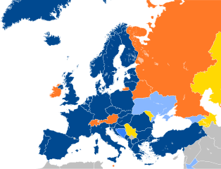
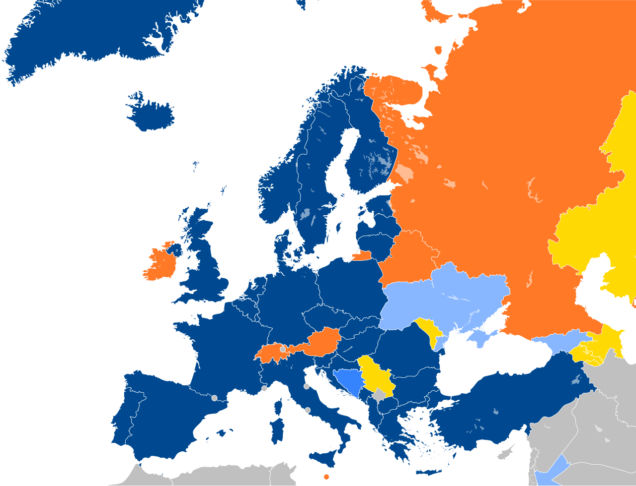
English: Map to show current affiliations of European Countries with the North Atlantic Treaty Organization (NATO). Several NATO Member areas not included in the map, such as the United States, Canada, and French Guiana. 다음을 기초로 한 자작: NATO enlargement.svg.
Current members Accession protocol signed Membership Action Plan Enhanced Opportunity Partner
Deutsch: Karte zur Darstellung der aktuellen Zugehörigkeiten europäischer Länder zur Nordatlantikpakt-Organisation (NATO). Mehrere NATO-Mitgliedsgebiete sind nicht in der Karte enthalten, wie die Vereinigten Staaten, Kanada und Französisch-Guayana. Eigene Arbeit basierend auf: NATO enlargement.svg.
aktuelle Mitglieder Länder im Beitrittsprozess Aktionsplan für die Mitgliedschaft Enhanced Opportunity Partner Individueller Partnerschaftsaktionsplan
Čeština: Mapa zobrazující partnerské smlouvy NATO v Evropě a okolí.
Français : Carte montrant les affiliations actuelles des pays européens avec l'OTAN. Plusieurs membres en dehors de l'Europe ne sont pas représentés.
Membres actuels Protocole d'adhésion signé Plan d'action pour l'adhésion Partenaire d'opportunités améliorées
Português: Mapa serve para mostrar as afiliações atuais dos países europeus com a Organização do Tratado do Atlântico Norte (NATO/OTAN). Várias áreas membros da OTAN não incluídas no mapa, como Estados Unidos, Canadá e Guiana Francesa. 다음을 기초로 한 자작: NATO enlargement.svg.
Estados-membros da NATO Protocolo de Adesão Assinado Plano de Ação de Adesão Parceiros de Oportunidades Alargadas |
| 날짜 | |
| 출처 |
이 파일은 다음에 의해 파생됨: |
| 저자 | Patrick |
| SVG 발전 |
라이선스
[편집]
나는 아래 작품의 저작권자로서, 이 저작물을 다음과 같은 라이선스로 배포합니다:
| 나는 이 작품의 저작권자로서, 이 작품을 퍼블릭 도메인으로 모두에게 공개합니다. 이 공개 선언은 전 세계적으로 유효합니다. 만약 저작권의 포기가 법률적으로 가능하지 않은 경우, 나는 이 작품을 법적으로 허용되는 한도 내에서 누구나 자유롭게 어떤 목적으로도 제한없이 사용할 수 있도록 허용합니다. |
기존 올리기 기록
[편집]
This image is a derivative work of the following images:
- NATO affiliations in Europe.svg licensed with PD-self
- 2011-12-20T01:35:53Z Patrickneil 897x691 (469519 Bytes) Reverted to version as of 19:54, 7 June 2010 I may have been hasty, basing change on one RIA Novosti article
- 2011-12-19T05:46:00Z Patrickneil 897x691 (469528 Bytes) Georgia updated with MAP
- 2010-06-07T19:54:39Z Patrickneil 897x691 (469519 Bytes) Corrections: Serbia in orange, Kosovo and Cyprus in gray
- 2010-05-22T20:57:29Z Patrickneil 897x691 (469519 Bytes) {{Information |Description={{en|Blank map of Europe}} Map to show current affiliations of European Countries with the [[North Atlantic Treaty Organization - Organisation du traité de l'Atlantique Nord|North Atlantic Treaty O
Uploaded with derivativeFX
파일 역사
날짜/시간 링크를 클릭하면 해당 시간의 파일을 볼 수 있습니다.
| 날짜/시간 | 섬네일 | 크기 | 사용자 | 설명 | |
|---|---|---|---|---|---|
| 현재 | 2024년 3월 8일 (금) 00:28 | | 725 × 555 (721 KB) | Danlaycock (토론 | 기여) | russia and belarus are still members, just suspended |
| 2024년 3월 7일 (목) 18:18 |  | 725 × 555 (717 KB) | Sariyr (토론 | 기여) | + SWE, - Russia and Belarus from the Partnership for Peace | |
| 2023년 4월 3일 (월) 21:59 |  | 725 × 555 (721 KB) | Louloumra59 (토론 | 기여) | FIN | |
| 2023년 4월 3일 (월) 16:46 |  | 725 × 555 (721 KB) | Louloumra59 (토론 | 기여) | They will join tuesday, no today ! | |
| 2023년 4월 3일 (월) 15:17 |  | 725 × 555 (721 KB) | Edroeh (토론 | 기여) | +FIN | |
| 2023년 2월 25일 (토) 00:01 |  | 725 × 555 (721 KB) | Danlaycock (토론 | 기여) | rvt erroneous edit - neither georgia nor ukraine have a MAP like Bosnia (https://www.nato.int/cps/en/natohq/topics_37356.htm#:~:text=The%20Membership%20Action%20Plan%20(MAP,and%20Herzegovina%20is%20currently%20participating.) | |
| 2023년 2월 24일 (금) 21:15 |  | 680 × 520 (479 KB) | TBAG654321 (토론 | 기여) | Corrected Georgia and Ukraine | |
| 2023년 1월 4일 (수) 16:59 |  | 725 × 555 (721 KB) | Danlaycock (토론 | 기여) | rvt erroneous edit, Kosovo does not have a Membership Action Plan from NATO, it isn't even a Partnership for Peace participant yet (https://www.aa.com.tr/en/europe/kosovo-aims-to-join-natos-partnership-for-peace-program-in-2023/2771517) | |
| 2023년 1월 4일 (수) 11:48 |  | 725 × 555 (746 KB) | HelpfulHens (토론 | 기여) | Reverted to version as of 15:01, 1 January 2023 (UTC) | |
| 2023년 1월 1일 (일) 16:44 |  | 725 × 555 (721 KB) | Danlaycock (토론 | 기여) | rvt - Kosovo was already on the map, you've now miscoloured it |
이 파일을 덮어쓸 수 없습니다.
이 파일을 사용하는 문서
이 파일을 사용하는 문서가 없습니다.
이 파일을 사용하고 있는 모든 위키의 문서 목록
다음 위키에서 이 파일을 사용하고 있습니다:
- ar.wikipedia.org에서 이 파일을 사용하고 있는 문서 목록
- bs.wikipedia.org에서 이 파일을 사용하고 있는 문서 목록
- cs.wikipedia.org에서 이 파일을 사용하고 있는 문서 목록
- de.wikipedia.org에서 이 파일을 사용하고 있는 문서 목록
- el.wikipedia.org에서 이 파일을 사용하고 있는 문서 목록
- en.wikipedia.org에서 이 파일을 사용하고 있는 문서 목록
- eo.wikipedia.org에서 이 파일을 사용하고 있는 문서 목록
- es.wikipedia.org에서 이 파일을 사용하고 있는 문서 목록
- eu.wikipedia.org에서 이 파일을 사용하고 있는 문서 목록
- fa.wikipedia.org에서 이 파일을 사용하고 있는 문서 목록
- fr.wikipedia.org에서 이 파일을 사용하고 있는 문서 목록
- Organisation du traité de l'Atlantique nord
- Conseil de partenariat euro-atlantique
- Partenariat pour la paix
- Dispositif de l'OTAN en Méditerranée
- Élargissement de l'OTAN
- Modèle:OTAN et monde
- Initiative de coopération d'Istanbul
- Steadfast Defender 24
- Modèle:OTAN et monde/Bac à sable
- Modèle:OTAN et monde/Documentation
- gl.wikipedia.org에서 이 파일을 사용하고 있는 문서 목록
- hu.wikipedia.org에서 이 파일을 사용하고 있는 문서 목록
- ko.wikipedia.org에서 이 파일을 사용하고 있는 문서 목록
- pt.wikipedia.org에서 이 파일을 사용하고 있는 문서 목록
- ro.wikipedia.org에서 이 파일을 사용하고 있는 문서 목록
- ru.wikipedia.org에서 이 파일을 사용하고 있는 문서 목록
- sr.wikipedia.org에서 이 파일을 사용하고 있는 문서 목록
- ta.wikipedia.org에서 이 파일을 사용하고 있는 문서 목록
- tr.wikipedia.org에서 이 파일을 사용하고 있는 문서 목록
- uk.wikipedia.org에서 이 파일을 사용하고 있는 문서 목록
이 파일의 더 많은 사용 내역을 봅니다.