File:Map 13 Marie Byrd Land Ed 3.jpg
קפיצה לניווט
קפיצה לחיפוש

גודל התצוגה המקדימה הזאת: 418 × 599 פיקסלים. רזולוציות אחרות: 167 × 240 פיקסלים | 335 × 480 פיקסלים | 536 × 768 פיקסלים | 714 × 1,024 פיקסלים | 1,429 × 2,048 פיקסלים | 2,880 × 4,128 פיקסלים.
לקובץ המקורי (2,880 × 4,128 פיקסלים, גודל הקובץ: 1.02 מ"ב, סוג MIME: image/jpeg)
כיתובים
כיתובים
נא להוסיף משפט שמסביר מה הקובץ מייצג
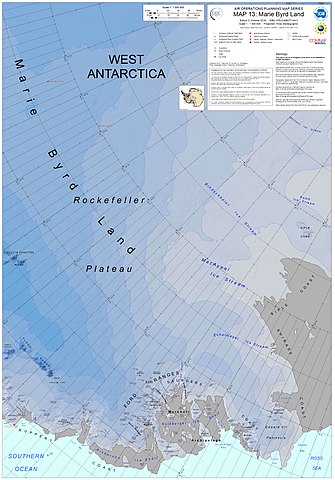
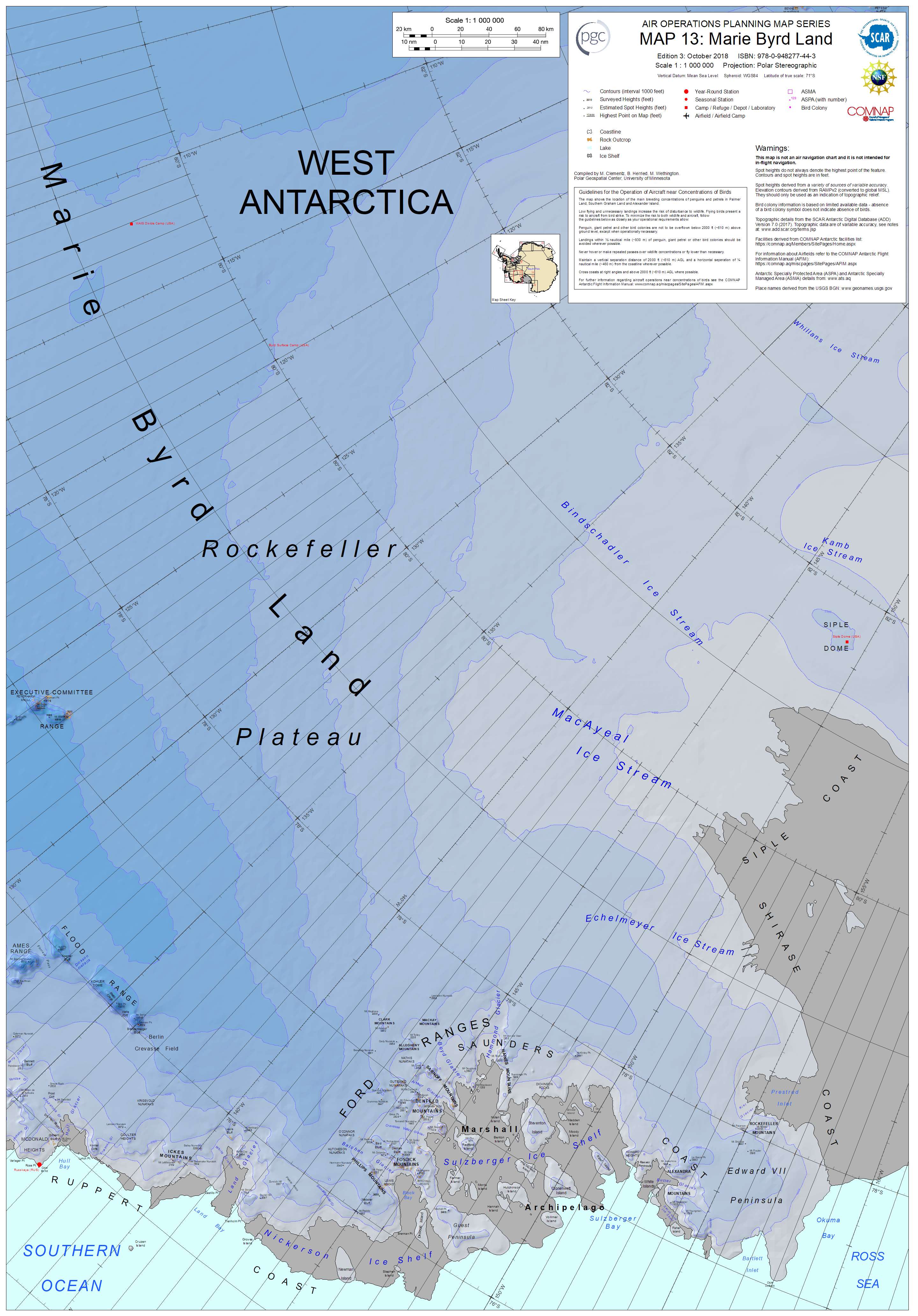
Eastern Marie Byrd Land and its geographic features
תקציר
[עריכה]
| תיאור |
English: Air Operations Planning Map Series, Map 13: Marie Byrd Land, 3rd Edition, October 2018. ISBN: 978-0-948277-44-3, Polar Stereographic Projection, including the following features: the MacAyeal Ice Stream, Bindschadler Ice Stream, Siple Dome, Kamb Ice Stream, Echelmeyer Ice Stream, Edward VII Peninsula, Rockefeller Plateau, and many others |
| תאריך יצירה | |
| מקור | http://data.pgc.umn.edu/maps/antarctica/pgc/17/preview/Map%2013%20Marie%20Byrd%20Land%20Ed%203.jpg |
| יוצר | M. Clementz, B. Herried, and M. Wethington as a work-for-hire of the Polar Geospacial Center, University of Michigan |
רישיון
[עריכה]

|
בעלי זכויות היוצרים על הקובץ הזה, the Polar Geospatial Center, מאשרים לכולם להשתמש בו לכל מטרה, בתנאי שניתן לבעלי הזכויות ייחוס נאות. הפצה, יצירות נגזרות, שימושים מסחריים וכל שימוש אחר מותרים. |
ייחוס:
Polar Geospatial Center, 2018, PGC Map Catalog, https://doi.org/10.7910/DVN/6R8F7U, Harvard Dataverse, V1, Map 13, 29 July 2019]
|
היסטוריית הקובץ
ניתן ללחוץ על תאריך/שעה כדי לראות את הקובץ כפי שנראה באותו זמן.
| תאריך/שעה | תמונה ממוזערת | ממדים | משתמש | הערה | |
|---|---|---|---|---|---|
| נוכחית | 04:21, 30 ביולי 2019 | | 4,128 × 2,880 (1.02 מ"ב) | A loose necktie (שיחה | תרומות) | User created page with UploadWizard |
אין באפשרותך לדרוס את הקובץ הזה.
שימוש בקובץ
הדף הבא משתמש בקובץ הזה:
שימוש גלובלי בקובץ
אתרי הוויקי השונים הבאים משתמשים בקובץ זה:
- שימוש באתר he.wikipedia.org
- שימוש באתר pl.wikipedia.org