File:Map Cymru 1996 gyda rhifau.svg
קפיצה לניווט
קפיצה לחיפוש

גודל התצוגה המקדימה הזאת מסוג PNG של קובץ ה־SVG הזה: 483 × 600 פיקסלים. רזולוציות אחרות: 193 × 240 פיקסלים | 386 × 480 פיקסלים | 618 × 768 פיקסלים | 824 × 1,024 פיקסלים | 1,649 × 2,048 פיקסלים | 500 × 621 פיקסלים.
לקובץ המקורי (קובץ SVG, הגודל המקורי: 500 × 621 פיקסלים, גודל הקובץ: 50 ק"ב)
כיתובים
כיתובים
נא להוסיף משפט שמסביר מה הקובץ מייצג
תקציר[עריכה]
This version has all the extra SVG-cruft removed, all counties in separate groups, and the "id" field of each group set to the Welsh name of each county rather than a number.
| תיאור | Same as Image:Map Cymru 1996 heb enwau.svg, but the numbers from Image:WalesNumbered.png have been added back. |
| מקור | Image:WalesNumbered.png + GIMP + VectorMagic + Inkscape + emacs |
| יוצר | User:Marnanel, after en:User:Morwen |
| אישורים והיתרים (שימוש חוזר בקובץ זה) |
GFDL |
| גרסאות אחרות | Image:WalesNumbered.png |
רישיון[עריכה]
| הקובץ הזה מתפרסם לפי תנאי רישיון קריאייטיב קומונז ייחוס-שיתוף זהה 3.0 לא מותאם. Subject to disclaimers. | ||
| ||
| תבנית רישוי זו הוספה לקובץ כחלק מעדכון רישיון GFDL. |

|
מוענקת בכך הרשות להעתיק, להפיץ או לשנות את המסמך הזה, לפי תנאי הרישיון לשימוש חופשי במסמכים של גנו, גרסה 1.2 או כל גרסה מאוחרת יותר שתפורסם על־ידי המוסד לתוכנה חופשית; ללא פרקים קבועים, ללא טקסט עטיפה קדמית וללא טקסט עטיפה אחורית. עותק של הרישיון כלול בפרק שכותרתו הרישיון לשימוש חופשי במסמכים של גנו. Subject to disclaimers. |
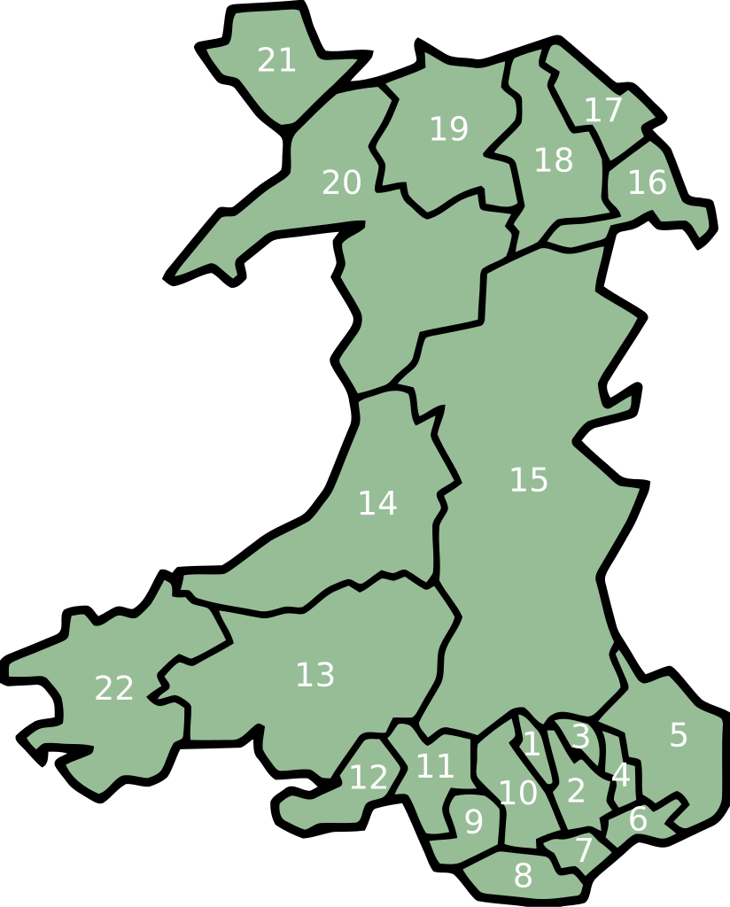
key[עריכה]
- Merthyr Tydfil/Merthyr Tudful
- Caerphilly/Caerffili
- Blaenau Gwent
- Torfaen/Tor-faen
- Monmouthshire/Sir Fynwy
- Newport/Casnewydd
- Cardiff/Caerdydd
- Vale of Glamorgan/Bro Morgannwg
- Bridgend/Pen-y-bont ar Ogwr
- Rhondda Cynon Taff/Rhondda Cynon Tâf
- Neath Port Talbot/Castell-nedd Port Talbot
- Swansea/Abertawe
- Carmarthenshire/Sir Gaerfyrddin
- Ceredigion
- Powys
- Wrexham/Wrecsam
- Flintshire/Sir y Fflint
- Denbighshire/Sir Ddinbych
- Conwy
- Gwynedd
- Isle of Anglesey/Ynys Môn
- Pembrokeshire/Sir Benfro
היסטוריית הקובץ
ניתן ללחוץ על תאריך/שעה כדי לראות את הקובץ כפי שנראה באותו זמן.
| תאריך/שעה | תמונה ממוזערת | ממדים | משתמש | הערה | |
|---|---|---|---|---|---|
| נוכחית | 02:06, 12 בפברואר 2008 | | 621 × 500 (50 ק"ב) | Marnanel (שיחה | תרומות) | This version has all the extra SVG-cruft removed, all counties in separate groups, and the "id" field of each group set to the Welsh name of each county rather than a number. {{Information |Description=Same as Image:Map Cymru 1996 heb enwau.svg, but |
אין באפשרותך לדרוס את הקובץ הזה.
שימוש בקובץ
אין דפים המשתמשים בקובץ זה.
שימוש גלובלי בקובץ
אתרי הוויקי השונים הבאים משתמשים בקובץ זה:
- שימוש באתר br.wikipedia.org
- שימוש באתר el.wikipedia.org
- שימוש באתר en.wikipedia.org
- שימוש באתר eu.wikipedia.org
- Britainia Handia
- Gales
- Cardiff
- Llanfairpwllgwyngyll
- Swansea
- Gwynedd
- Denbighshire
- Ynys Môn
- Carmarthenshire
- Ceredigion
- Newport (Gales)
- Merthyr Tydfil
- Vale of Glamorgan
- Blaenau Gwent
- Torfaen
- Monmouthshire
- Pembrokeshire
- Conwy
- Flintshire
- Wrecsam
- Bridgend
- Rhondda Cynon Taf
- Castell-nedd Port Talbot
- Powys
- Portmeirion
- Blaenau Ffestiniog
- Pwllheli
- Txantiloi:Galesko eskualde aurkibidea
- Galesko azpibanaketak
- Bangor (Gales)
- Cricieth
- Harlech
- Llanbedr
- Aberangell
- Aberdesach
- Aberdyfi
- Abererch
- Abergeirw
- Abergwyngregyn
- Abergynolwyn
- Aberllefenni
- Abersoch
- Abertrinant
- Afon Wen
- Arthog
- Bala (Gales)
צפייה בשימושים גלובליים נוספים של קובץ זה.