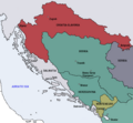
File:Map of the Kingdom of Croatia-Slavonia (1885).png
Wikimedia Commons, 자유로운 미디어 저장소
둘러보기로 이동
검색으로 이동
Map_of_the_Kingdom_of_Croatia-Slavonia_(1885).png (542 × 502 픽셀, 파일 크기: 31 KB, MIME 종류: image/png)
파일 정보
구조화된 데이터
캡션
설명
이 파일이 나타내는 바에 대한 한 줄 설명을 추가합니다
파일 설명[편집]
| 설명Map of the Kingdom of Croatia-Slavonia (1885).png |
English: Map of the Kingdom of Croatia Slavonia cca. 1885. The Kingdom was a part of Transleithanian Austria-Hungary, the Kingdom of Hungary (Lands of the Crown of St. Stephen). |
| 날짜 | |
| 출처 | 자작 |
| 저자 | DIREKTOR |
라이선스[편집]
| Public domainPublic domainfalsefalse |
| 나는 이 작품의 저작권자로서, 이 작품을 퍼블릭 도메인으로 모두에게 공개합니다. 이 공개 선언은 전 세계적으로 유효합니다. 만약 저작권의 포기가 법률적으로 가능하지 않은 경우, 나는 이 작품을 법적으로 허용되는 한도 내에서 누구나 자유롭게 어떤 목적으로도 제한없이 사용할 수 있도록 허용합니다. |
| 주석 InfoField | 이 이미지에는 주석이 있습니다: 공용에서 주석을 보기 |
402
305
139
119
542
502
It's mistake! The territory of Sandžak (Sanjak) was ruled by Ottoman Empire until 1912! Then passed half and half to Serbia and Montenegro.-- Iaroslavvs, 26 November 2009
파일 역사
날짜/시간 링크를 클릭하면 해당 시간의 파일을 볼 수 있습니다.
| 날짜/시간 | 섬네일 | 크기 | 사용자 | 설명 | |
|---|---|---|---|---|---|
| 현재 | 2009년 10월 11일 (일) 11:11 |  | 542 × 502 (31 KB) | DIREKTOR (토론 | 기여) | {{Information |Description={{en|1=Map of the Kingdom of Croatia Slavonia cca. 1885. The Kingdom was a part of Transleithanian Austria-Hungary, the Kingdom of Hungary (Lands of the Crown of St. Stephen).}} |Source={{own}} |Author=DIREKTOR |
| 2009년 10월 11일 (일) 11:07 |  | 542 × 502 (33 KB) | DIREKTOR (토론 | 기여) | {{Information |Description={{en|1=Map of the Kingdom of Croatia Slavonia cca. 1885. The Kingdom was a part of Transleithanian Austria-Hungary, the Kingdom of Hungary (Lands of the Crown of St. Stephen).}} |Source={{own}} |Author=DIREKTOR | |
| 2009년 10월 10일 (토) 21:31 |  | 542 × 502 (33 KB) | DIREKTOR (토론 | 기여) | {{Information |Description={{en|1=Map of the Kingdom of Croatia Slavonia cca. 1885. The Kingdom was a part of Transleithanian Austria-Hungary, the Kingdom of Hungary (Lands of the Crown of St. Stephen).}} |Source={{own}} |Author=DIREKTOR |
이 파일을 덮어쓸 수 없습니다.
이 파일을 사용하는 문서
다음 문서 3개가 이 파일을 사용하고 있습니다:
이 파일을 사용하고 있는 모든 위키의 문서 목록
다음 위키에서 이 파일을 사용하고 있습니다:
- ar.wikipedia.org에서 이 파일을 사용하고 있는 문서 목록
- bs.wikipedia.org에서 이 파일을 사용하고 있는 문서 목록
- en.wikipedia.org에서 이 파일을 사용하고 있는 문서 목록
- fr.wikipedia.org에서 이 파일을 사용하고 있는 문서 목록
- ga.wikipedia.org에서 이 파일을 사용하고 있는 문서 목록
- he.wikipedia.org에서 이 파일을 사용하고 있는 문서 목록
- id.wikipedia.org에서 이 파일을 사용하고 있는 문서 목록
- ka.wikipedia.org에서 이 파일을 사용하고 있는 문서 목록
- ko.wikipedia.org에서 이 파일을 사용하고 있는 문서 목록
- ku.wikipedia.org에서 이 파일을 사용하고 있는 문서 목록
- pt.wikipedia.org에서 이 파일을 사용하고 있는 문서 목록
- sk.wikipedia.org에서 이 파일을 사용하고 있는 문서 목록
- sr.wikipedia.org에서 이 파일을 사용하고 있는 문서 목록
- tr.wikipedia.org에서 이 파일을 사용하고 있는 문서 목록
- uk.wikipedia.org에서 이 파일을 사용하고 있는 문서 목록
- www.wikidata.org에서 이 파일을 사용하고 있는 문서 목록
분류:
- Maps of the history of Croatia (1526–1918)
- Maps of the Kingdom of Dalmatia
- Maps of the history of Bosnia and Herzegovina under Ottoman Empire
- Maps of the history of Montenegro in modern times
- Maps of the history of Sandžak
- Maps of the Kingdom of Croatia-Slavonia
- Maps of vilayets of the Ottoman Empire
- Bosnia Vilayet
- Principality of Montenegro
