File:Milano - mappa servizio ferroviario suburbano (schematica).svg
둘러보기로 이동
검색으로 이동

SVG 파일의 PNG 형식의 미리보기 크기: 612 × 599 픽셀. 다른 해상도: 245 × 240 픽셀 | 490 × 480 픽셀 | 784 × 768 픽셀 | 1,046 × 1,024 픽셀 | 2,091 × 2,048 픽셀 | 1,210 × 1,185 픽셀
원본 파일 (SVG 파일, 실제 크기 1,210 × 1,185 픽셀, 파일 크기: 2.62 MB)
캡션
설명
이 파일이 나타내는 바에 대한 한 줄 설명을 추가합니다
파일 설명
[편집]| 설명 |
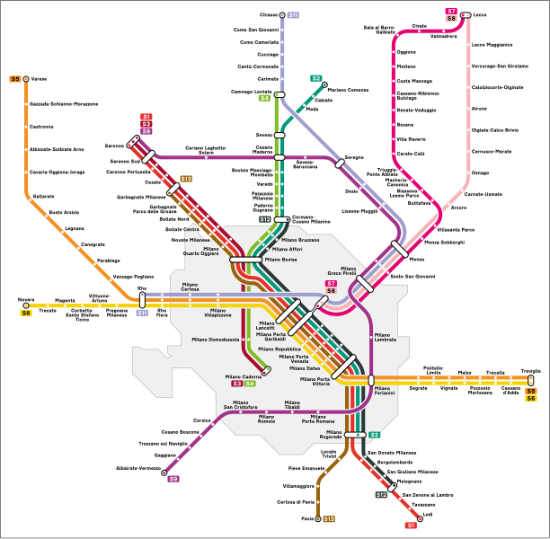
Italiano: Mappa del servizio ferroviario suburbano di Milano. |
| 출처 | 자작 |
| 저자 | Arbalete |
| 저작권 (이 파일을 인용하기) |
나는 아래 작품의 저작권자로서, 이 저작물을 다음과 같은 라이선스로 배포합니다: 이 파일은 크리에이티브 커먼즈 저작자표시-동일조건변경허락 4.0 국제 라이선스로 배포됩니다.
|
| 다른 버전 |
|
.png)
.svg)
.svg&action=edit§ion=1)
파일 역사
날짜/시간 링크를 클릭하면 해당 시간의 파일을 볼 수 있습니다.
.svg&uselang=ko&dir=prev)
.svg&uselang=ko&offset=20161015201433)
.svg&uselang=ko&offset=&limit=20)
.svg&uselang=ko&offset=&limit=50)
.svg&uselang=ko&offset=&limit=100)
.svg&uselang=ko&offset=&limit=250)
.svg&uselang=ko&offset=&limit=500)
| 날짜/시간 | 섬네일 | 크기 | 사용자 | 설명 | |
|---|---|---|---|---|---|
| 현재 | 2024년 6월 10일 (월) 14:38 | | 1,210 × 1,185 (2.62 MB) | Arbalete (토론 | 기여) | Aggiorno (S12 a Cormano, S13 a Garbagnate) |
| 2023년 10월 2일 (월) 12:20 |  | 1,210 × 1,185 (2.58 MB) | CiaobyDany (토론 | 기여) | Aggiunta linea S12; correzioni minori | |
| 2023년 1월 28일 (토) 00:30 |  | 1,210 × 1,185 (2.74 MB) | Arbalete (토론 | 기여) | Non c'è alcuna linea in costruzione | |
| 2023년 1월 26일 (목) 12:11 |  | 1,210 × 1,185 (2.73 MB) | Arrow303 (토론 | 기여) | Correzione linee S7/S8 + inserito prolungamento in costruzione S13 fino a Garbagnate M.se (cfr. Mappa Ufficiale Trenord novembre 2022: https://trenord-europe-trenord-endpoint-prd.azureedge.net/fileadmin/contenuti/TRENORD/2-Linee_e_orari/Linee_Suburbane_Urbane/Suburbano_2022_A4_linked_rev00_-_Copia.pdf) | |
| 2022년 12월 2일 (금) 20:58 |  | 1,210 × 1,185 (2.74 MB) | Arbalete (토론 | 기여) | Piccola correzione | |
| 2022년 12월 2일 (금) 06:23 |  | 1,210 × 1,185 (2.74 MB) | Arbalete (토론 | 기여) | Aggiorno con modifiche dell'11 dicembre 2022 (Milano Tibaldi, Villasanta Parco) | |
| 2021년 6월 16일 (수) 12:11 |  | 1,116 × 900 (1,004 KB) | Arbalete (토론 | 기여) | Aggiorno (stazione Camerlata FS) | |
| 2019년 1월 13일 (일) 15:25 |  | 1,116 × 900 (999 KB) | Arbalete (토론 | 기여) | Aggiorno (stazioni di Cesano Maderno Groane e Ceriano Groane chiuse il 10 dicembre 2012). | |
| 2016년 10월 15일 (토) 20:17 |  | 1,116 × 900 (1,012 KB) | I.sorry (토론 | 기여) | Correzione colore ufficiale S12 | |
| 2016년 10월 15일 (토) 20:14 |  | 1,116 × 900 (1,012 KB) | I.sorry (토론 | 기여) | Correzione colore ufficiale linea S12 |
이 파일을 덮어쓸 수 없습니다.
이 파일을 사용하는 문서
다음 문서 45개가 이 파일을 사용하고 있습니다:
- User:Arbalete/Maps
- User:Chumwa/OgreBot/Potential transport maps/2016 May 21-31
- User:Chumwa/OgreBot/Potential transport maps/2016 October 11-20
- User:Chumwa/OgreBot/Potential transport maps/2016 September 11-20
- User:Chumwa/OgreBot/Potential transport maps/2019 January 11-20
- User:Chumwa/OgreBot/Public transport information/2015 December 1-10
- User:Chumwa/OgreBot/Public transport information/2015 December 11-20
- User:Chumwa/OgreBot/Public transport information/2015 November 21-30
- User:Chumwa/OgreBot/Public transport information/2016 May 21-31
- User:Chumwa/OgreBot/Public transport information/2016 October 11-20
- User:Chumwa/OgreBot/Public transport information/2016 September 11-20
- User:Chumwa/OgreBot/Public transport information/2019 January 11-20
- User:Chumwa/OgreBot/Public transport information/2021 June 11-20
- User:Chumwa/OgreBot/Public transport information/2022 December 1-10
- User:Chumwa/OgreBot/Public transport information/2023 January 21-31
- User:Chumwa/OgreBot/Public transport information/2023 October 1-10
- User:Chumwa/OgreBot/Public transport information/2024 June 1-10
- User:Chumwa/OgreBot/Transport Maps/2015 December 1-10
- User:Chumwa/OgreBot/Transport Maps/2015 December 11-20
- User:Chumwa/OgreBot/Transport Maps/2015 November 21-30
- User:Chumwa/OgreBot/Transport Maps/2016 May 21-31
- User:Chumwa/OgreBot/Transport Maps/2016 October 11-20
- User:Chumwa/OgreBot/Transport Maps/2016 September 11-20
- User:Chumwa/OgreBot/Transport Maps/2019 January 11-20
- User:Chumwa/OgreBot/Transport Maps/2021 June 11-20
- User:Chumwa/OgreBot/Transport Maps/2022 December 1-10
- User:Chumwa/OgreBot/Transport Maps/2023 January 21-31
- User:Chumwa/OgreBot/Transport Maps/2023 October 1-10
- User:Chumwa/OgreBot/Transport Maps/2024 June 1-10
- User:Chumwa/OgreBot/Travel and communication maps/2016 May 21-31
- User:Chumwa/OgreBot/Travel and communication maps/2016 October 11-20
- User:Chumwa/OgreBot/Travel and communication maps/2016 September 11-20
- User:Chumwa/OgreBot/Travel and communication maps/2019 January 11-20
- User:Chumwa/OgreBot/Travel and communication maps/2024 June 1-10
- User:J budissin/Uploads/BiH/2019 January 11-20
- User:Magog the Ogre/Multilingual legend/2021 June 11-20
- User:Magog the Ogre/Multilingual legend/2022 December 1-10
- User:Magog the Ogre/Multilingual legend/2023 January 21-31
- User:Magog the Ogre/Multilingual legend/2023 October 1-4
- User:Magog the Ogre/Multilingual legend/2024 June 6-10
- File:Milano - mappa servizio ferroviario suburbano (schematica).png
- File:Milano - mappa servizio ferroviario suburbano e metropolitana (schematica).svg
- File:Milano linee S.svg (파일 넘겨주기)
- File:Milano mappa servizio ferroviario suburbano.svg (파일 넘겨주기)
- Category:Milan suburban railway service
이 파일을 사용하고 있는 모든 위키의 문서 목록
다음 위키에서 이 파일을 사용하고 있습니다:
- de.wikipedia.org에서 이 파일을 사용하고 있는 문서 목록
- en.wikipedia.org에서 이 파일을 사용하고 있는 문서 목록
- fr.wikipedia.org에서 이 파일을 사용하고 있는 문서 목록
- it.wikipedia.org에서 이 파일을 사용하고 있는 문서 목록
- ja.wikipedia.org에서 이 파일을 사용하고 있는 문서 목록
- ko.wikipedia.org에서 이 파일을 사용하고 있는 문서 목록
- lmo.wikipedia.org에서 이 파일을 사용하고 있는 문서 목록
- oc.wikipedia.org에서 이 파일을 사용하고 있는 문서 목록
- pnb.wikipedia.org에서 이 파일을 사용하고 있는 문서 목록
- ur.wikipedia.org에서 이 파일을 사용하고 있는 문서 목록
- www.wikidata.org에서 이 파일을 사용하고 있는 문서 목록
- zh.wikipedia.org에서 이 파일을 사용하고 있는 문서 목록
.svg&oldid=884122745)