File:Mweru Wantipa from space.jpg
קפיצה לניווט
קפיצה לחיפוש
אין גרסה ברזולוציה גבוהה יותר.
Mweru_Wantipa_from_space.jpg (325 × 198 פיקסלים, גודל הקובץ: 15 ק"ב, סוג MIME: image/jpeg)
כיתובים
כיתובים
נא להוסיף משפט שמסביר מה הקובץ מייצג
תקציר
[עריכה]
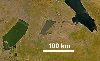
| תיאור | Lake Mweru Wantipa (Mweru Marshes) in northern Zambia photographed from space. Mweru Wantipa is a shallow muddy lake shown in the centre between the greenish Lake Mweru and the dark blue Lake Tanganyika. |
| תאריך יצירה | 26 March 2007 (Original 2000-07-23) |
| מקור | cropped from: NASA Visible Earth website |
| יוצר | NASA, Credit SeaWiFS Project, NASA/Goddard Space Flight Center, and ORBIMAGE |
| אישורים והיתרים (שימוש חוזר בקובץ זה) |
Public domain |
רישיון
[עריכה]
| This image is from the Sea-viewing Wide Field-of-view Sensor (SeaWiFS) Project and more than 5 years old.
Satellite data captured by the SeaWIFS sensor are released into the public domain 5 years after capture. Data less than five years old can be re-used only for educational or scientific purposes; any commercial use of such images must be coordinated with GeoEye. [1] |
| This work has been released into the public domain by its copyright holder, GeoEye. This applies worldwide. יש מדינות שבהן הדבר אינו אפשרי על פי חוק, אם כך: GeoEye מעניק לכל אחד את הזכות להשתמש ביצירה הזאת לכל מטרה, ללא שום תנאי, אלא אם כן תנאים כאלה נדרשים לפי החוק.
|
היסטוריית הקובץ
ניתן ללחוץ על תאריך/שעה כדי לראות את הקובץ כפי שנראה באותו זמן.
| תאריך/שעה | תמונה ממוזערת | ממדים | משתמש | הערה | |
|---|---|---|---|---|---|
| נוכחית | 05:56, 27 במרץ 2007 | | 198 × 325 (15 ק"ב) | Rexparry sydney~commonswiki (שיחה | תרומות) | {{Information |Description=Lake Mweru Wantipa (Mweru Marshes) in northern Zambia photographed from space. Mweru Wantipa is a shallow muddy lake shown in the centre between the greenish Lake Mweru and the dark blue Lake Tanganyika. |Source=[htt |
אין באפשרותך לדרוס את הקובץ הזה.
שימוש בקובץ
אין דפים המשתמשים בקובץ זה.
שימוש גלובלי בקובץ
אתרי הוויקי השונים הבאים משתמשים בקובץ זה:
- שימוש באתר arz.wikipedia.org
- שימוש באתר be.wikipedia.org
- שימוש באתר bh.wikipedia.org
- שימוש באתר ca.wikipedia.org
- שימוש באתר de.wikipedia.org
- שימוש באתר en.wikipedia.org
- שימוש באתר es.wikipedia.org
- שימוש באתר fi.wikipedia.org
- שימוש באתר fr.wikipedia.org
- שימוש באתר he.wikipedia.org
- שימוש באתר it.wikipedia.org
- שימוש באתר ka.wikipedia.org
- שימוש באתר lt.wikipedia.org
- שימוש באתר lv.wikipedia.org
- שימוש באתר my.wikipedia.org
- שימוש באתר nl.wikipedia.org
- שימוש באתר pl.wikipedia.org
- שימוש באתר ru.wikipedia.org
- שימוש באתר te.wikipedia.org
- שימוש באתר uk.wikipedia.org
- שימוש באתר www.wikidata.org
- שימוש באתר zh.wikipedia.org