File:Noahsworld map.png
קפיצה לניווט
קפיצה לחיפוש

גודל התצוגה המקדימה הזאת: 402 × 599 פיקסלים. רזולוציות אחרות: 161 × 240 פיקסלים | 322 × 480 פיקסלים.
לקובץ המקורי (800 × 1,192 פיקסלים, גודל הקובץ: 337 ק"ב, סוג MIME: image/png)
כיתובים
כיתובים
נא להוסיף משפט שמסביר מה הקובץ מייצג
| תיאור |
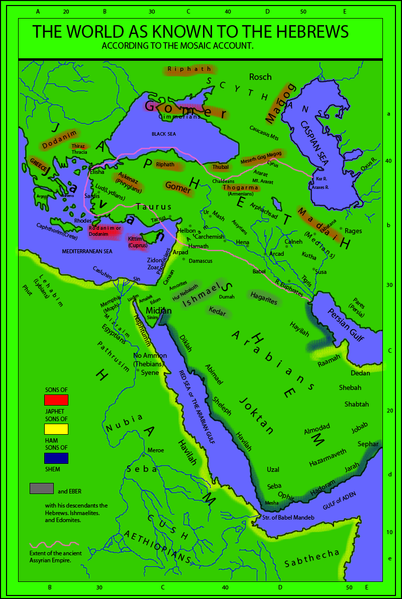
English: The world as known to the Hebrews. A map from "Historical Textbook and Atlas of Biblical Geography (1854)" by Lyman Coleman |
||||||||||||||
| תאריך יצירה | |||||||||||||||
| מקור |
|
||||||||||||||
| יוצר |
|
||||||||||||||
| אישורים והיתרים (שימוש חוזר בקובץ זה) |
|
||||||||||||||
| גרסאות אחרות |
This map derives from a 1854 map   |
||||||||||||||
_(14793127233)_(cropped).jpg)
היסטוריית הקובץ
ניתן ללחוץ על תאריך/שעה כדי לראות את הקובץ כפי שנראה באותו זמן.
| תאריך/שעה | תמונה ממוזערת | ממדים | משתמש | הערה | |
|---|---|---|---|---|---|
| נוכחית | 20:18, 19 בפברואר 2010 | | 1,192 × 800 (337 ק"ב) | Megistias (שיחה | תרומות) | Added, Zidon, Zoar, Arpad, Aram, Arphachsad, Mash, Carchemish, Calneh, (Armenians) parentheses in Medians. Ludim, Amalek, Edom, Midian and Sinim. Kaspian, Kur R., |
| 14:40, 19 בפברואר 2010 |  | 1,192 × 800 (331 ק"ב) | Megistias (שיחה | תרומות) | {{Information |Description={{en|The World as known to the Hebrews. A map from Historical Textbook and Atlas of Biblical Geography (1854) by Coleman}} |Source= *map from Historical Textbook and Atlas of Biblical Geography (1854) by Coleman *Historical Orig |
אין באפשרותך לדרוס את הקובץ הזה.
שימוש בקובץ
הדפים הבאים משתמשים בקובץ הזה:
שימוש גלובלי בקובץ
אתרי הוויקי השונים הבאים משתמשים בקובץ זה:
- שימוש באתר bo.wikipedia.org
- שימוש באתר en.wikipedia.org
- שימוש באתר ko.wikipedia.org