File:North Pacific Subtropical Convergence Zone.jpg
둘러보기로 이동
검색으로 이동
최대 해상도입니다.
North_Pacific_Subtropical_Convergence_Zone.jpg (400 × 290 픽셀, 파일 크기: 104 KB, MIME 종류: image/jpeg)
캡션
설명
이 파일이 나타내는 바에 대한 한 줄 설명을 추가합니다


파일 설명
[편집]
| 설명 |
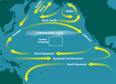
English: Map of the North Pacific Subtropical Convergence Zone (STCZ) within the North Pacific Gyre. Also the location of the Great Pacific Garbage Patch. |
| 날짜 | 날짜를 알 수 없음 |
| 출처 | http://marinedebris.noaa.gov/info/patch.html |
| 저자 | NOAA |
| 저작권 (이 파일을 인용하기) |
Public domain |
| 다른 버전 | 이 파일은 다음으로 파생됨: North Pacific Subtropical Convergence Zone-es.png |
라이선스
[편집]
|
|
파일 역사
날짜/시간 링크를 클릭하면 해당 시간의 파일을 볼 수 있습니다.
| 날짜/시간 | 섬네일 | 크기 | 사용자 | 설명 | |
|---|---|---|---|---|---|
| 현재 | 2010년 6월 29일 (화) 05:10 | | 400 × 290 (104 KB) | Dcoetzee (토론 | 기여) | Remove watermark reading "WWW.MARINEDEBRIS.NOAA.GOV" |
| 2009년 5월 18일 (월) 07:41 |  | 400 × 290 (107 KB) | Renamed user ixgysjijel (토론 | 기여) | {{Information |Description={{en|1=Map of the North Pacific Subtropical Convergence Zone (STCZ) within the North Pacific Gyre. Also the location of the Great Pacific Garbage Patch.}} |Source=http://marinedebris.noaa.gov/info/patch.html |Author=NOAA |Date= |
이 파일을 덮어쓸 수 없습니다.
이 파일을 사용하는 문서
다음 문서 1개가 이 파일을 사용하고 있습니다:
이 파일을 사용하고 있는 모든 위키의 문서 목록
다음 위키에서 이 파일을 사용하고 있습니다:
- ar.wikipedia.org에서 이 파일을 사용하고 있는 문서 목록
- ca.wikipedia.org에서 이 파일을 사용하고 있는 문서 목록
- da.wikipedia.org에서 이 파일을 사용하고 있는 문서 목록
- en.wikipedia.org에서 이 파일을 사용하고 있는 문서 목록
- Thomas Cavendish
- High-nutrient, low-chlorophyll regions
- North Pacific Gyre
- Great Pacific garbage patch
- Maritime history of California
- Marine plastic pollution
- Boundary current
- Ecosystem of the North Pacific Subtropical Gyre
- User:Horn.kali/sandbox
- United Nations Ocean Conference
- User:Vanisheduser431890/sandbox
- Thomas Cavendish's circumnavigation
- en.wikiversity.org에서 이 파일을 사용하고 있는 문서 목록
- es.wikipedia.org에서 이 파일을 사용하고 있는 문서 목록
- fa.wikipedia.org에서 이 파일을 사용하고 있는 문서 목록
- fr.wikipedia.org에서 이 파일을 사용하고 있는 문서 목록
- he.wikipedia.org에서 이 파일을 사용하고 있는 문서 목록
- id.wikipedia.org에서 이 파일을 사용하고 있는 문서 목록
- ig.wikipedia.org에서 이 파일을 사용하고 있는 문서 목록
- it.wikipedia.org에서 이 파일을 사용하고 있는 문서 목록
- ja.wikipedia.org에서 이 파일을 사용하고 있는 문서 목록
- ko.wikipedia.org에서 이 파일을 사용하고 있는 문서 목록
- krc.wikipedia.org에서 이 파일을 사용하고 있는 문서 목록
- mdf.wikipedia.org에서 이 파일을 사용하고 있는 문서 목록
- nl.wikipedia.org에서 이 파일을 사용하고 있는 문서 목록
- pl.wikipedia.org에서 이 파일을 사용하고 있는 문서 목록
- pt.wikipedia.org에서 이 파일을 사용하고 있는 문서 목록
- ru.wikipedia.org에서 이 파일을 사용하고 있는 문서 목록
- simple.wikipedia.org에서 이 파일을 사용하고 있는 문서 목록
- sl.wikipedia.org에서 이 파일을 사용하고 있는 문서 목록
- sv.wikipedia.org에서 이 파일을 사용하고 있는 문서 목록
- th.wikipedia.org에서 이 파일을 사용하고 있는 문서 목록
- uk.wikipedia.org에서 이 파일을 사용하고 있는 문서 목록
이 파일의 더 많은 사용 내역을 봅니다.