File:Old map of Monmouth, Wales.jpg

לקובץ המקורי (2,269 × 1,774 פיקסלים, גודל הקובץ: 1.17 מ"ב, סוג MIME: image/jpeg)
כיתובים
כיתובים
תקציר[עריכה]
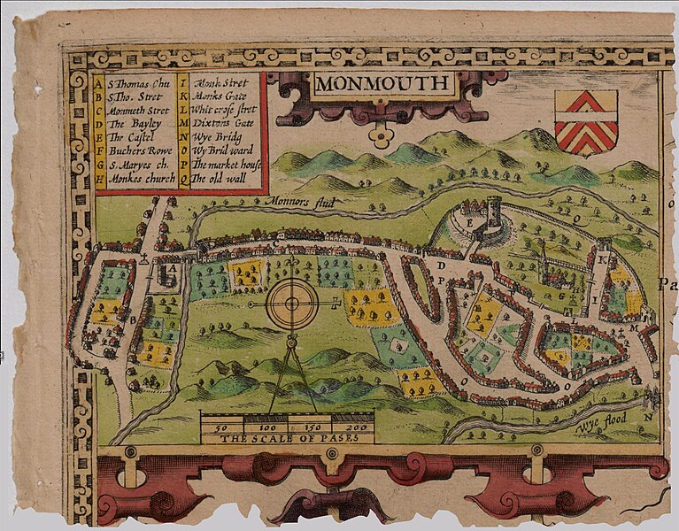
John Speed's Map of Monmouth, Wales, 1610. No copyright, public domain.
Source: Part of: The Countye of Monmouth
רישיון[עריכה]
This image is in the public domain because it is a mere mechanical scan or photocopy of a public domain original, or – from the available evidence – is so similar to such a scan or photocopy that no copyright protection can be expected to arise. The original itself is in the public domain for the following reason:
This tag is designed for use where there may be a need to assert that any enhancements (eg brightness, contrast, colour-matching, sharpening) are in themselves insufficiently creative to generate a new copyright. It can be used where it is unknown whether any enhancements have been made, as well as when the enhancements are clear but insufficient. For known raw unenhanced scans you can use an appropriate {{PD-old}} tag instead. For usage, see Commons:When to use the PD-scan tag.  | ||||
היסטוריית הקובץ
ניתן ללחוץ על תאריך/שעה כדי לראות את הקובץ כפי שנראה באותו זמן.
| תאריך/שעה | תמונה ממוזערת | ממדים | משתמש | הערה | |
|---|---|---|---|---|---|
| נוכחית | 15:08, 19 ביוני 2015 | | 1,774 × 2,269 (1.17 מ"ב) | Joop Rotte (שיחה | תרומות) | Leukere kleurtjes, hogere resolutie |
| 14:02, 18 בדצמבר 2006 |  | 798 × 1,170 (769 ק"ב) | TTKK (שיחה | תרומות) | Speede's Map of Monmouth, UK, 1610. No copyright, public domain |
אין באפשרותך לדרוס את הקובץ הזה.
שימוש בקובץ
אין דפים המשתמשים בקובץ זה.
שימוש גלובלי בקובץ
אתרי הוויקי השונים הבאים משתמשים בקובץ זה:
- שימוש באתר ar.wikipedia.org
- שימוש באתר ca.wikipedia.org
- שימוש באתר cs.wikipedia.org
- שימוש באתר en.wikipedia.org
- Monmouth
- John Speed
- Monnow Bridge
- Wikipedia:GLAM/MonmouthpediA/Images
- Church Street, Monmouth
- Wikipedia:GLAM/MonmouthpediA/Visit/JohnSpeedMonmouthMap
- Monmouth Alms Houses
- Monnow Street
- Wikipedia:Recent additions/2012/May
- User:John Cummings/Archive/Trails
- Monmouth town walls and defences
- Whitecross Street, Monmouth
- Template:Did you know nominations/Whitecross Street, Monmouth
- Monk Street, Monmouth
- Masonic Hall, Monmouth
- St James Square, Monmouth
- St James Street, Monmouth
- St James House, Monmouth
- Glendower Street, Monmouth
- St John's, Monmouth
- Wye Bridge Ward, Monmouth
- Template:Did you know nominations/Wye Bridge Ward, Monmouth
- User:Verbcatcher/sandbox
- שימוש באתר es.wikipedia.org
- שימוש באתר et.wikipedia.org
- שימוש באתר he.wikipedia.org
- שימוש באתר hif.wikipedia.org
- שימוש באתר hi.wikipedia.org
- שימוש באתר hr.wikipedia.org
- שימוש באתר hu.wikipedia.org
- שימוש באתר id.wikipedia.org
- שימוש באתר ig.wikipedia.org
- שימוש באתר it.wikipedia.org
- שימוש באתר ja.wikipedia.org
- שימוש באתר nn.wikipedia.org
- שימוש באתר ru.wikipedia.org
- שימוש באתר sh.wikipedia.org
- שימוש באתר sr.wikipedia.org
- שימוש באתר sv.wikipedia.org
- שימוש באתר uk.wikipedia.org
- שימוש באתר www.wikidata.org