File:PIA16105 malin04ano-br2.jpg

원본 파일 (1,024 × 684 픽셀, 파일 크기: 125 KB, MIME 종류: image/jpeg)
캡션
설명
파일 설명[편집]
| 설명 |
English: 08.27.2012
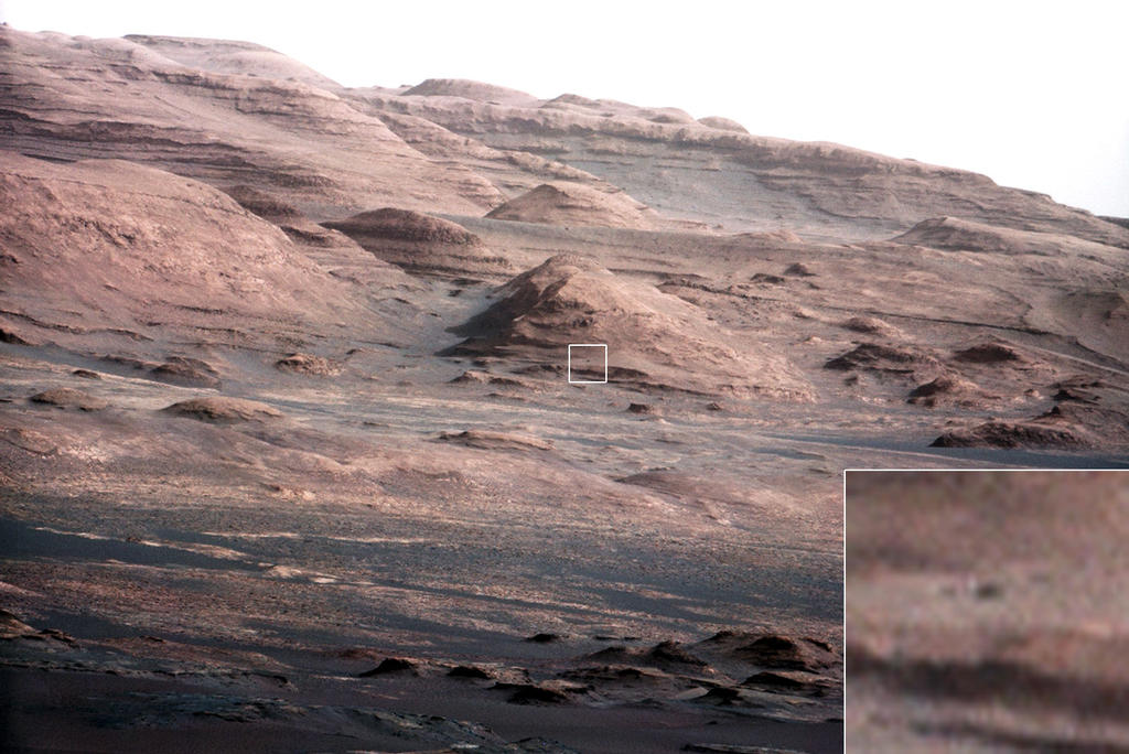
Layers at the Base of Mount Sharp A chapter of the layered geological history of Mars is laid bare in this postcard from NASA's Curiosity rover. The image shows the base of Mount Sharp, the rover's eventual science destination. This image is a portion of a larger image taken by Curiosity's 100-millimeter Mast Camera on Aug. 23, 2012. See http://photojournal.jpl.nasa.gov/catalog/PIA16104. Scientists enhanced the color in one version to show the Martian scene under the lighting conditions we have on Earth, which helps in analyzing the terrain. For scale, an annotated version of the figure highlights a dark rock that is approximately the same size as Curiosity. The pointy mound in the center of the image, looming above the rover-sized rock, is about 1,000 feet (300 meters) across and 300 feet (100 meters) high. To see a close-up of the layered buttes of Mount Sharp, see http://photojournal.jpl.nasa.gov/catalog/PIA16105. Image Credit: NASA/JPL-Caltech/MSSS |
| 날짜 | |
| 출처 | http://mars.jpl.nasa.gov/msl/images/PIA16105_malin04ano-br2.jpg |
| 저자 | NASA/JPL-Caltech/MSSS |
라이선스[편집]
| 이 파일은 NASA에서 제작하였으므로 퍼블릭 도메인입니다. NASA의 저작권 정책에 따르면 NASA의 자료는 명시하지 않는 이상 저작권의 보호를 받지 않습니다. (Template:PD-USGov, 또는 NASA 저작권 정책 문서, JPL 그림 사용 정책을 참고하세요.) | ||
 |
주의사항:
|
파일 역사
날짜/시간 링크를 클릭하면 해당 시간의 파일을 볼 수 있습니다.
| 날짜/시간 | 섬네일 | 크기 | 사용자 | 설명 | |
|---|---|---|---|---|---|
| 현재 | 2012년 8월 27일 (월) 23:44 | | 1,024 × 684 (125 KB) | Drbogdan (토론 | 기여) | User created page with UploadWizard |
이 파일을 덮어쓸 수 없습니다.
이 파일을 사용하는 문서
이 파일을 사용하는 문서가 없습니다.
이 파일을 사용하고 있는 모든 위키의 문서 목록
다음 위키에서 이 파일을 사용하고 있습니다:
- bn.wikipedia.org에서 이 파일을 사용하고 있는 문서 목록
- ca.wikipedia.org에서 이 파일을 사용하고 있는 문서 목록
- en.wikipedia.org에서 이 파일을 사용하고 있는 문서 목록
- es.wikipedia.org에서 이 파일을 사용하고 있는 문서 목록
- fa.wikipedia.org에서 이 파일을 사용하고 있는 문서 목록
- kk.wikipedia.org에서 이 파일을 사용하고 있는 문서 목록
- ko.wikipedia.org에서 이 파일을 사용하고 있는 문서 목록
- ro.wikipedia.org에서 이 파일을 사용하고 있는 문서 목록
- test.wikipedia.org에서 이 파일을 사용하고 있는 문서 목록
- tr.wikipedia.org에서 이 파일을 사용하고 있는 문서 목록
- uk.wikipedia.org에서 이 파일을 사용하고 있는 문서 목록
- zh.wikipedia.org에서 이 파일을 사용하고 있는 문서 목록