File:PIA16154 fig1-Mars Curiosity Rover - Road To Glenelg.jpg

원본 파일 (1,280 × 363 픽셀, 파일 크기: 671 KB, MIME 종류: image/jpeg)
캡션
설명
파일 설명
[편집]
| 설명 |
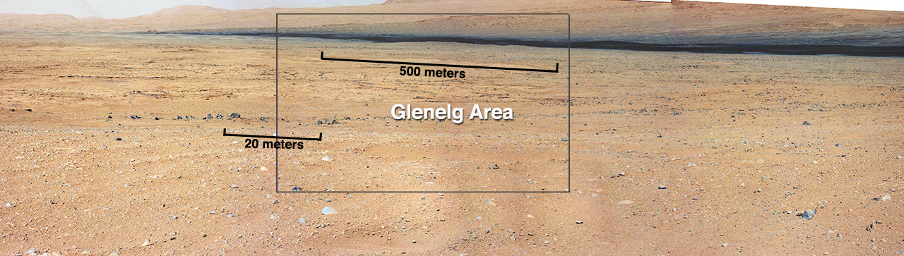
English: PIA16154: On the Road to Glenelg (Annotated)
This mosaic from the Mast Camera on NASA's Curiosity rover shows the view looking toward the "Glenelg" area, where three different terrain types come together. All three types are observed from orbit with the High-Resolution Imaging Science Experiment (HiRISE) camera on NASA's Mars Reconnaissance Orbiter. By driving there, Curiosity will be able to explore them. One of the three terrain types is light-toned with well-developed layering, which likely records deposits of sedimentary materials. There are also black bands that run through the area and might constitute additional layers that alternate with the light-toned layers. The black bands are not easily seen from orbit and are on the order of about 3.3-feet (1-meter) thick. Both of these layer types are important science targets. This mosaic is composed of seven images. The Mastcam 34-millimeter camera took a series of four images; embedded within that series is a second set of three images taken with the Mastcam 100-millimeter camera. |
| 날짜 | |
| 출처 | http://photojournal.jpl.nasa.gov/figures/PIA16154_fig1.jpg |
| 저자 | NASA/JPL-Caltech/MSSS |
| 다른 버전 | http://photojournal.jpl.nasa.gov/catalog/PIA16154 |
라이선스
[편집]
| 이 파일은 NASA에서 제작하였으므로 퍼블릭 도메인입니다. NASA의 저작권 정책에 따르면 NASA의 자료는 명시하지 않는 이상 저작권의 보호를 받지 않습니다. (Template:PD-USGov, 또는 NASA 저작권 정책 문서, JPL 그림 사용 정책을 참고하세요.) | ||
 |
주의사항:
|
파일 역사
날짜/시간 링크를 클릭하면 해당 시간의 파일을 볼 수 있습니다.
| 날짜/시간 | 섬네일 | 크기 | 사용자 | 설명 | |
|---|---|---|---|---|---|
| 현재 | 2012년 9월 20일 (목) 01:40 | 1,280 × 363 (671 KB) | Drbogdan (토론 | 기여) | User created page with UploadWizard |
이 파일을 덮어쓸 수 없습니다.
이 파일을 사용하는 문서
이 파일을 사용하는 문서가 없습니다.
이 파일을 사용하고 있는 모든 위키의 문서 목록
다음 위키에서 이 파일을 사용하고 있습니다:
- bn.wikipedia.org에서 이 파일을 사용하고 있는 문서 목록
- de.wikipedia.org에서 이 파일을 사용하고 있는 문서 목록
- en.wikipedia.org에서 이 파일을 사용하고 있는 문서 목록
- fa.wikipedia.org에서 이 파일을 사용하고 있는 문서 목록
- ja.wikipedia.org에서 이 파일을 사용하고 있는 문서 목록
- kk.wikipedia.org에서 이 파일을 사용하고 있는 문서 목록
- ko.wikipedia.org에서 이 파일을 사용하고 있는 문서 목록
- lb.wikipedia.org에서 이 파일을 사용하고 있는 문서 목록
- ru.wikipedia.org에서 이 파일을 사용하고 있는 문서 목록
- test.wikipedia.org에서 이 파일을 사용하고 있는 문서 목록
- uk.wikipedia.org에서 이 파일을 사용하고 있는 문서 목록
- vi.wikipedia.org에서 이 파일을 사용하고 있는 문서 목록
- zh.wikipedia.org에서 이 파일을 사용하고 있는 문서 목록