File:PIA17192-SaturnMoon-Enceladus-GeyserLocations-20150414.jpg
원본 파일 (900 × 900 픽셀, 파일 크기: 91 KB, MIME 종류: image/jpeg)
캡션
설명
파일 설명[편집]
| 설명 |
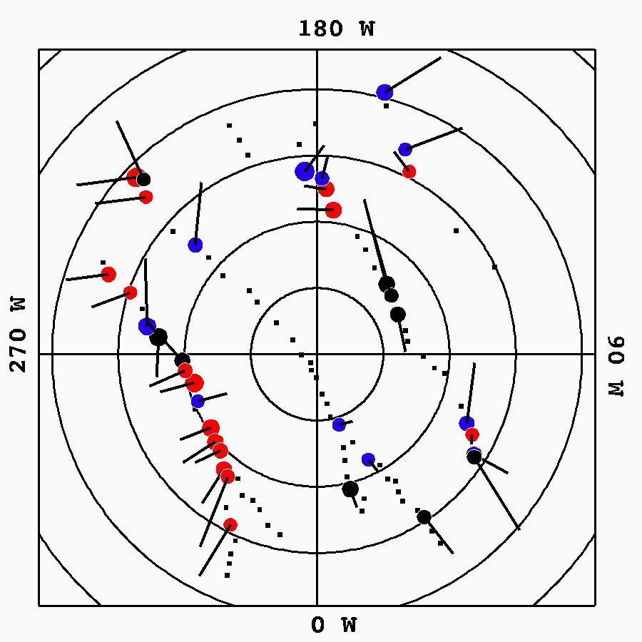
English: PIA17192: Tendril-producing Geysers on Enceladus' South Polar Terrain
http://photojournal.jpl.nasa.gov/catalog/PIA17192 This graphic plots the source locations of the geysers scientists have located on Enceladus' south polar terrain. The 36 most active geyser, or jet, sources are marked by circles and color coded by the behavior of the grains erupting from the geysers. Other, less active sources are marked by small black squares. Red sources produce structures that lead Enceladus in its orbit, blue sources produce particles that trail the moon, and black sources produce both. Circle size is proportional to the source activity level. Latitudes are plotted as concentric circles centered on the south pole at 5-degree intervals. Lines emanating from sources represent the projection of a source's central emission vector onto Saturn's ringplane -- that is, the direction of a source's emission projected onto a plane passing through Saturn's equator. In this reference frame, Saturn is down and Enceladus' orbital motion to the right. The Cassini mission is a cooperative project of NASA, ESA (the European Space Agency) and the Italian Space Agency. The Jet Propulsion Laboratory, a division of the California Institute of Technology in Pasadena, manages the mission for NASA's Science Mission Directorate, Washington. The Cassini orbiter and its two onboard cameras were designed, developed and assembled at JPL. The imaging operations center is based at the Space Science Institute in Boulder, Colorado. For more information about the Cassini-Huygens mission visit http://saturn.jpl.nasa.gov and http://www.nasa.gov/cassini. The Cassini imaging team homepage is at http://ciclops.org. |
| 날짜 | |
| 출처 | http://photojournal.jpl.nasa.gov/jpeg/PIA17192.jpg |
| 저자 | NASA/JPL-Caltech/Space Science Institute |
라이선스[편집]
| 이 파일은 NASA에서 제작하였으므로 퍼블릭 도메인입니다. NASA의 저작권 정책에 따르면 NASA의 자료는 명시하지 않는 이상 저작권의 보호를 받지 않습니다. (Template:PD-USGov, 또는 NASA 저작권 정책 문서, JPL 그림 사용 정책을 참고하세요.) | ||
 |
주의사항:
|
파일 역사
날짜/시간 링크를 클릭하면 해당 시간의 파일을 볼 수 있습니다.
| 날짜/시간 | 섬네일 | 크기 | 사용자 | 설명 | |
|---|---|---|---|---|---|
| 현재 | 2015년 4월 16일 (목) 13:12 | | 900 × 900 (91 KB) | Drbogdan (토론 | 기여) | User created page with UploadWizard |
이 파일을 덮어쓸 수 없습니다.
이 파일을 사용하는 문서
이 파일을 사용하는 문서가 없습니다.
이 파일을 사용하고 있는 모든 위키의 문서 목록
다음 위키에서 이 파일을 사용하고 있습니다:
- cs.wikipedia.org에서 이 파일을 사용하고 있는 문서 목록
- en.wikipedia.org에서 이 파일을 사용하고 있는 문서 목록
- gl.wikipedia.org에서 이 파일을 사용하고 있는 문서 목록
- ko.wikipedia.org에서 이 파일을 사용하고 있는 문서 목록
- ro.wikipedia.org에서 이 파일을 사용하고 있는 문서 목록
- uz.wikipedia.org에서 이 파일을 사용하고 있는 문서 목록