File:Palestine 01-Palestine (FL196625077 1125297).jpg
קפיצה לניווט
קפיצה לחיפוש

גודל התצוגה המקדימה הזאת: 433 × 599 פיקסלים. רזולוציות אחרות: 173 × 240 פיקסלים | 347 × 480 פיקסלים | 555 × 768 פיקסלים | 740 × 1,024 פיקסלים | 1,743 × 2,410 פיקסלים.
לקובץ המקורי (1,743 × 2,410 פיקסלים, גודל הקובץ: 4.19 מ"ב, סוג MIME: image/jpeg)
כיתובים
כיתובים
נא להוסיף משפט שמסביר מה הקובץ מייצג
תקציר
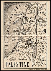
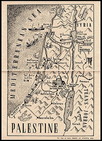
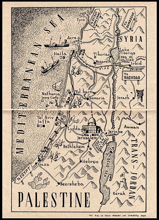
[עריכה]| Palestine
( |
||||||||||||||||||||||||
|---|---|---|---|---|---|---|---|---|---|---|---|---|---|---|---|---|---|---|---|---|---|---|---|---|
| כותרת |
Palestine |
|||||||||||||||||||||||
| מפרסם |
Middle East Forces |
|||||||||||||||||||||||
| תיאור |
Palestine.. |
|||||||||||||||||||||||
| שפה | אנגלית | |||||||||||||||||||||||
| תאריך הוצאה לאור | 1945 | |||||||||||||||||||||||
| טכניקה | 1 sheet ; | |||||||||||||||||||||||
| ממדים | גובה: 20 ס"מ; רוחב: 14 ס"מ | |||||||||||||||||||||||
| אוסף |
|
|||||||||||||||||||||||
| מיקום נוכחי |
|
|||||||||||||||||||||||
| מיקום הוצאה | ממלכת בריטניה הגדולה | |||||||||||||||||||||||
| חיפוש בקטלוג מרחב | ממלכת בריטניה הגדולה | |||||||||||||||||||||||
| הערות | In: Middle East theatre. [Great Britain], Middle East Forces, [1945]. Before p.24. [2022C789]; Index on previous page - map of the Nile delta region - includes indication to leave hostels; leave camps. Y.M.C.A. etc.; Pictorial map.; מפת אזור אלכסנדריה במצרים והדלתא של הנילוס ומפת ארץ ישראל כוללות התייחסות למחנות נופש צבאיים ומתקני חופשה, דת ופנאי לחיילי בריטניה. לדוגמא, מחנה נופש בנתניה [מחנה נופש נתניה]. | |||||||||||||||||||||||
| IE PID | IE196625075 | |||||||||||||||||||||||
| רוזטה שם קובץ | FL196625077 | |||||||||||||||||||||||
| מזהה רשומה בספרייה הלאומית (P3959) | 997011252973505171 | |||||||||||||||||||||||
| חיפוש בקטלוג מרחב | אנגלית | |||||||||||||||||||||||
| חיפוש בקטלוג מרחב | Middle East Forces | |||||||||||||||||||||||
| מקור/צלם |
|
|||||||||||||||||||||||
| גרסאות אחרות | ||||||||||||||||||||||||
| Jpg / Tif version |
|
|||||||||||||||||||||||

.jpg)

.jpg&action=edit§ion=1)
רישיון
[עריכה].jpg&action=edit§ion=2)
This UK artistic or literary work, of which the author is unknown and cannot be ascertained by reasonable enquiry, is in the public domain because it is one of the following:
|
 |
היסטוריית הקובץ
ניתן ללחוץ על תאריך/שעה כדי לראות את הקובץ כפי שנראה באותו זמן.
| תאריך/שעה | תמונה ממוזערת | ממדים | משתמש | הערה | |
|---|---|---|---|---|---|
| נוכחית | 17:17, 2 בספטמבר 2023 | | 2,410 × 1,743 (4.19 מ"ב) | Geagea (שיחה | תרומות) | pattypan 22.03 |
אין באפשרותך לדרוס את הקובץ הזה.
שימוש בקובץ
הדף הבא משתמש בקובץ הזה:
.jpg&oldid=797868081)