File:Pietro Vesconte, Civitas Acon Sive ptolomayda (FL6878593 2368199).jpg
קפיצה לניווט
קפיצה לחיפוש

גודל התצוגה המקדימה הזאת: 800 × 581 פיקסלים. רזולוציות אחרות: 320 × 233 פיקסלים | 640 × 465 פיקסלים | 1,024 × 744 פיקסלים | 1,280 × 930 פיקסלים | 2,266 × 1,647 פיקסלים.
לקובץ המקורי (2,266 × 1,647 פיקסלים, גודל הקובץ: 2.34 מ"ב, סוג MIME: image/jpeg)
כיתובים
כיתובים
נא להוסיף משפט שמסביר מה הקובץ מייצג
תקציר
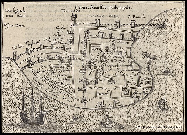
[עריכה]| פייטרו וסקונטה: Civitas Acon Sive ptolomayda
( |
||||||||||||||||||||||||
|---|---|---|---|---|---|---|---|---|---|---|---|---|---|---|---|---|---|---|---|---|---|---|---|---|
| אומן |
| |||||||||||||||||||||||
| יוצרים נוספים | Sanudo, Marino, approximately 1260-1343 | |||||||||||||||||||||||
| כותרת |
Civitas Acon Sive ptolomayda |
|||||||||||||||||||||||
| תיאור |
Civitas Acon Sive ptolomayda. Douilher fecit RI. |
|||||||||||||||||||||||
| שפה | לטינית | |||||||||||||||||||||||
| תאריך הוצאה לאור | המאה ה-16 | |||||||||||||||||||||||
| ממדים | גובה: 140 מ"מ; רוחב: 190 מ"מ | |||||||||||||||||||||||
| אוסף |
|
|||||||||||||||||||||||
| מיקום נוכחי |
|
|||||||||||||||||||||||
| מיקום הוצאה | unknown | |||||||||||||||||||||||
| חיפוש בקטלוג מרחב | unknown | |||||||||||||||||||||||
| הערות | Copperplate; Plan of Acco on a text page: Description de la Ville de Ptolemaide 3.; From: Les priuileges de l'Ordre de S.Iean de Hiervsalem, p. 26; The plan is an exact copy of Sanuto Vesconte's Acco, with decorations (ships) added. | |||||||||||||||||||||||
| IE PID | IE6878591 | |||||||||||||||||||||||
| רוזטה שם קובץ | FL6878593 | |||||||||||||||||||||||
| מזהה רשומה בספרייה הלאומית (P3959) | 990023681990205171 | |||||||||||||||||||||||
| חיפוש בקטלוג מרחב | לטינית, פייטרו וסקונטה | |||||||||||||||||||||||
| מקור/צלם |
|
|||||||||||||||||||||||
| גרסאות אחרות | ||||||||||||||||||||||||
| Jpg / Tif version |
|
|||||||||||||||||||||||
.jpg)

.jpg)

.jpg&action=edit§ion=1)
רישיון
[עריכה].jpg&action=edit§ion=2)
The copyright situation of this work is theoretically uncertain, because in the country of origin copyright lasts 70 years after the death of the author, and the date of the author's death is unknown. However, the date of creation of the work was over 120 years ago, and it is thus a reasonable assumption that the copyright has expired (see here for the community discussion). Do not use this template if the date of death of the author is known.
| |
| הקובץ הזה זוהה כקובץ חופשי מכל מגבלה ידועה תחת חוק זכויות היוצרים, כולל כל הזכויות הקשורות והסמוכות. | |
היסטוריית הקובץ
ניתן ללחוץ על תאריך/שעה כדי לראות את הקובץ כפי שנראה באותו זמן.
| תאריך/שעה | תמונה ממוזערת | ממדים | משתמש | הערה | |
|---|---|---|---|---|---|
| נוכחית | 01:09, 28 ביולי 2023 | | 1,647 × 2,266 (2.34 מ"ב) | Geagea (שיחה | תרומות) | pattypan 22.03 |
אין באפשרותך לדרוס את הקובץ הזה.
שימוש בקובץ
הדף הבא משתמש בקובץ הזה:
.jpg&oldid=787450115)