File:Rif Damashq.svg
둘러보기로 이동
검색으로 이동

SVG 파일의 PNG 형식의 미리보기 크기: 800 × 523 픽셀. 다른 해상도: 320 × 209 픽셀 | 640 × 418 픽셀 | 1,024 × 670 픽셀 | 1,280 × 837 픽셀 | 2,560 × 1,674 픽셀 | 1,485 × 971 픽셀
원본 파일 (SVG 파일, 실제 크기 1,485 × 971 픽셀, 파일 크기: 7.38 MB)
캡션
설명
이 파일이 나타내는 바에 대한 한 줄 설명을 추가합니다

파일 설명
[편집]| 설명 |
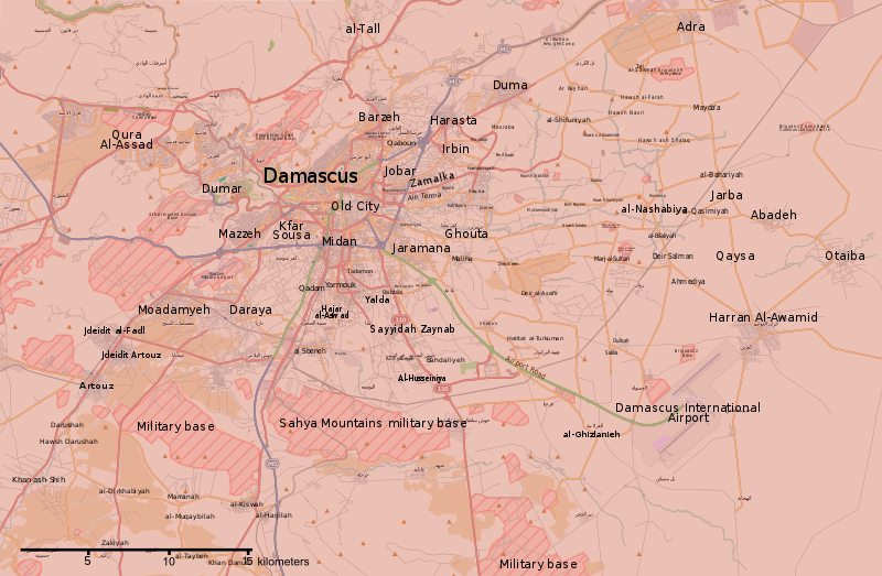
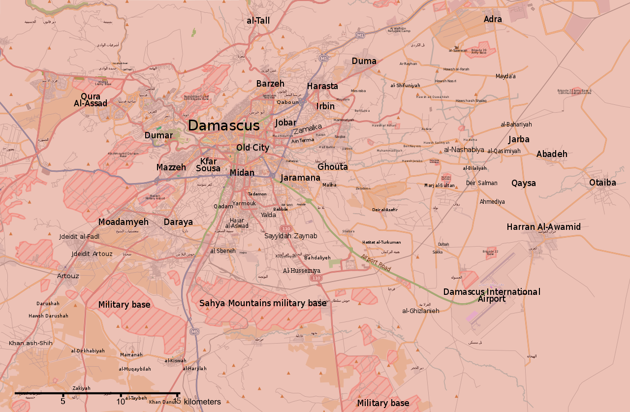
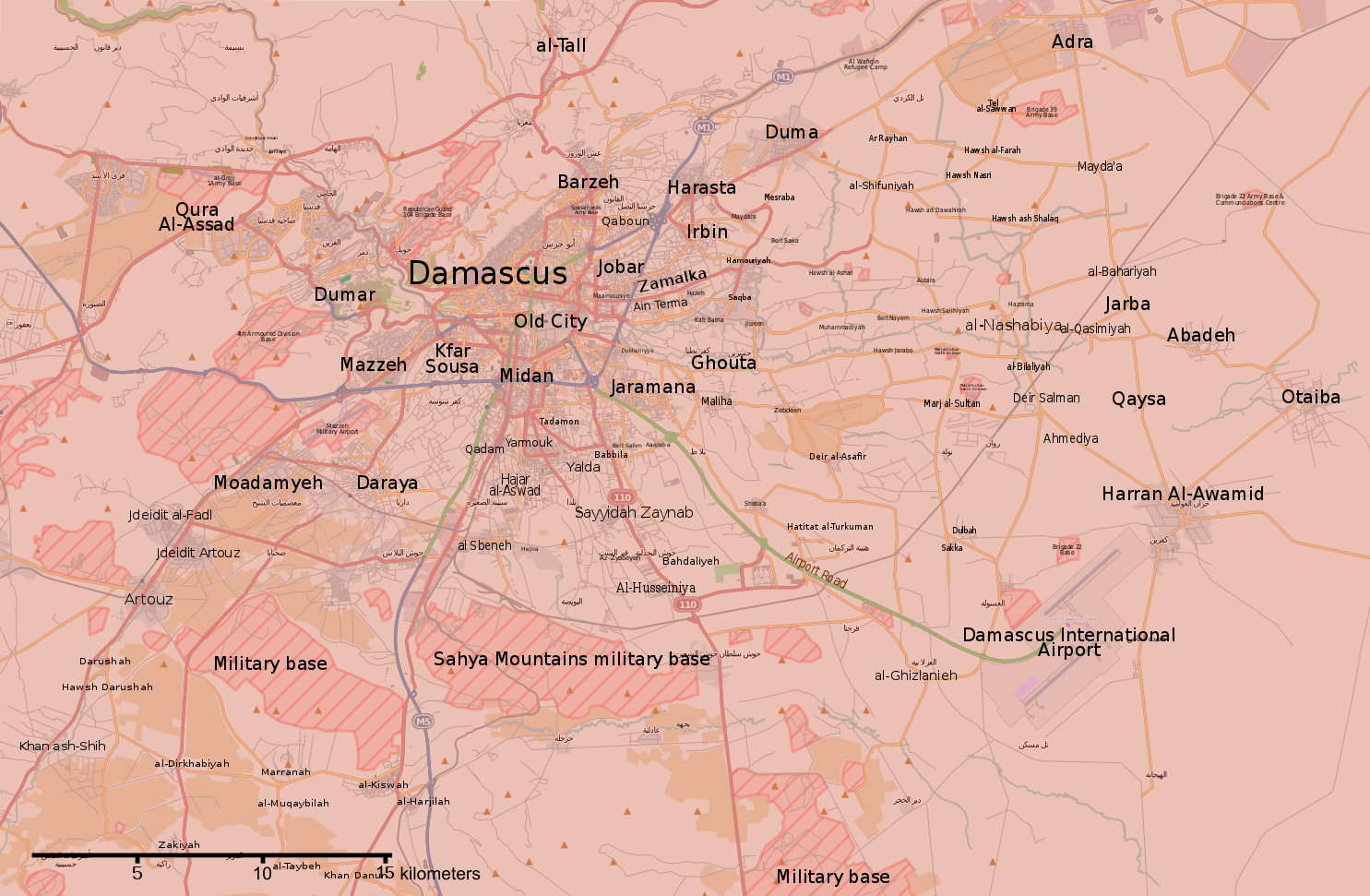
English: Map of the situation in Damascus and Rif Damashq during the Syrian Civil War.
English: Controlled by the Syrian Government
Controlled by the Syrian opposition
Controlled by the Islamic State of Iraq and the Levant
Truce/ceasefire zones
Contested/unclear situation العربية: خريطة الوضع في دمشق وريف دمشق خلال الحرب الأهلية السورية
تسيطر عليها الحكومة السورية
تسيطر عليها المعارضة السورية
تسيطر عليها تنظيم الدولة الإسلامية
مناطق الهدنة/وقف إطلاق النار
الحالة المتنازع عليها/غير الواضحة |
||||
| 날짜 | |||||
| 출처 | File:Rif Dimashq offensive (September 2013).svg | ||||
| 저자 | MrPenguin20 | ||||
| 다른 버전 |
|
||||
| SVG 발전 | 이 SVG 파일의 소스 코드를 6가지의 실수입니다. |


.svg)


.svg)


.svg)


_Territory_Change_2014-2016.gif)

_(within_Northern_Syria).svg)


.png)
.svg)


_map.png)
.svg)


.svg)


.svg)
라이선스
[편집]
| This work contains information from OpenStreetMap, which is made available under the Open Database License (ODbL).
The ODbL does not require any particular license for maps produced from ODbL data. Prior to 1 August 2020, map tiles produced by the OpenStreetMap Foundation were licensed under the CC-BY-SA-2.0 license. Maps produced by other people may be subject to other licences. |
이 파일은 크리에이티브 커먼즈 저작자표시-동일조건변경허락 3.0 Unported 라이선스로 배포됩니다.
- 이용자는 다음의 권리를 갖습니다:
- 공유 및 이용 – 저작물의 복제, 배포, 전시, 공연 및 공중송신
- 재창작 – 저작물의 개작, 수정, 2차적저작물 창작
- 다음과 같은 조건을 따라야 합니다:
- 저작자표시 – 적절한 저작자 표시를 제공하고, 라이센스에 대한 링크를 제공하고, 변경사항이 있는지를 표시해야 합니다. 당신은 합리적인 방식으로 표시할 수 있지만, 어떤 방식으로든 사용권 허가자가 당신 또는 당신의 사용을 지지하는 방식으로 표시할 수 없습니다.
- 동일조건변경허락 – 만약 당신이 이 저작물을 리믹스 또는 변형하거나 이 저작물을 기반으로 제작하는 경우, 당신은 당신의 기여물을 원저작물과 동일하거나 호환 가능한 라이선스에 따라 배포하여야 합니다.
파일 역사
날짜/시간 링크를 클릭하면 해당 시간의 파일을 볼 수 있습니다.
| 날짜/시간 | 섬네일 | 크기 | 사용자 | 설명 | |
|---|---|---|---|---|---|
| 현재 | 2018년 5월 22일 (화) 02:15 | | 1,485 × 971 (7.38 MB) | Kami888 (토론 | 기여) | damascus cleared |
| 2018년 5월 8일 (화) 05:56 |  | 1,485 × 971 (7.38 MB) | Kami888 (토론 | 기여) | updates | |
| 2018년 5월 4일 (금) 18:00 |  | 1,485 × 971 (7.38 MB) | Kami888 (토론 | 기여) | Evacuation of HTS and other non-ISIS rebels, ISIS pocket reported to be split in two. | |
| 2018년 4월 29일 (일) 18:41 |  | 1,485 × 971 (7.39 MB) | Kami888 (토론 | 기여) | ISIS withdrew from Qadam http://www.syriahr.com/en/?p=90681 | |
| 2018년 4월 26일 (목) 13:34 |  | 1,485 × 971 (7.39 MB) | Kami888 (토론 | 기여) | Taking update from https://pbs.twimg.com/media/Dbp4AVbX0AAxqSe.jpg:large as the only source that I know of that reports on situation in south damascus | |
| 2018년 4월 14일 (토) 02:42 |  | 1,485 × 971 (7.39 MB) | Kami888 (토론 | 기여) | Army of Islam evacuated from Douma | |
| 2018년 4월 1일 (일) 23:19 |  | 1,485 × 971 (7.45 MB) | Kami888 (토론 | 기여) | FAR and HTS evacuated to Idlib http://www.syriahr.com/2018/03/31/%d8%a8%d8%a7%d8%b3%d8%aa%d8%ab%d9%86%d8%a7%d8%a1-%d8%af%d9%88%d9%85%d8%a7-%d9%82%d9%88%d8%a7%d8%aa-%d8%a7%d9%84%d9%86%d8%b8%d8%a7%d9%85-%d8%aa%d9%81%d8%b1%d8%b6-%d8%b3%d9%8a%d8%b7%d8%b1%d8%aa/ | |
| 2018년 3월 27일 (화) 03:16 |  | 1,485 × 971 (7.71 MB) | Kami888 (토론 | 기여) | Changed Harasta to red per suggestion on talk page. Other towns still evacuating. | |
| 2018년 3월 25일 (일) 10:43 |  | 1,485 × 971 (7.76 MB) | Kami888 (토론 | 기여) | Changed Ein Terma/Hazeh. Evacuation from the other towns still appears to be ongoing. | |
| 2018년 3월 20일 (화) 12:00 |  | 1,485 × 971 (7.77 MB) | Kami888 (토론 | 기여) | south Qadam to contested |
이 파일을 덮어쓸 수 없습니다.
이 파일을 사용하는 문서
100개 이상의 문서가 이 파일을 사용하고 있습니다. 다음 목록은 이 파일을 사용하는 처음 문서 100개만 보여주고 있습니다. 이 파일을 사용하는 모든 문서 목록을 볼 수 있습니다.
- User:Geagea/Israel/2015 December 15
- User:Geagea/Israel/2015 December 23
- User:Geagea/Israel/2015 December 7
- User:Geagea/Israel/2015 November 15
- User:Geagea/Israel/2015 November 5
- User:Geagea/Israel/2015 November 6
- User:Hermes79
- User:Hermes7979
- User:Magog the Ogre/Maps of conflicts/2016 August
- User:Magog the Ogre/Maps of conflicts/2016 December
- User:Magog the Ogre/Maps of conflicts/2016 July
- User:Magog the Ogre/Maps of conflicts/2016 May
- User:Magog the Ogre/Maps of conflicts/2016 October
- User:Magog the Ogre/Maps of conflicts/2016 September
- User:Magog the Ogre/Maps of conflicts/2017 January
- User:Magog the Ogre/Maps of conflicts/2017 June
- User:Magog the Ogre/Maps of conflicts/2017 March
- User:Magog the Ogre/Maps of conflicts/2017 May
- User:Magog the Ogre/Maps of conflicts/2017 November
- File:2013 Hama Offensive.svg
- File:2015 Latakia Frontlines.svg
- File:Aleppo Offensives 2015.svg
- File:Aleppo offensive (October 2013).svg
- File:Attaques-terroristes-meurtrières-au-21eme-siecle.png
- File:Battle of Daraa City.svg
- File:Battle of Hasakah.svg
- File:Battle of Qamishli.svg
- File:Battle of Raqqa.svg
- File:Battle of Tadmur.svg
- File:Battle of Western Qalamoun.svg
- File:Battlefields in The Global War on Terror.svg
- File:Battlefields in The Global War on Terror - edit03.png
- File:Battlefields in The Global War on Terror - edit04.png
- File:Benghazi Conflict Detailed Map.png
- File:Benghazi Conflict Detailed Map.svg
- File:Boko Haram insurgency map.svg
- File:Countries by soldier count.svg
- File:Deir ez-Zor clashes (2017).svg
- File:Derna Conflict Detailed Map.png
- File:East Congo conflict map.svg
- File:GSPC map.png
- File:ISIS (Grey) Territory Change 2014-2016.gif
- File:Iraqi Civil War map (2014–present).png
- File:Iraqi–Kurdish conflict map.png
- File:Islamist insurgency in Nigeria.svg
- File:Lebanese insurgency.svg
- File:Libyan Civil War.svg
- File:Libyan war final-fr.svg
- File:Map of Ongoing conflicts around the world.png
- File:Map of terror of the Islamic State (ad-Daula al-islāmiyya).png
- File:Mexico states map small war.PNG
- File:Mosul offensive (2015) map.png
- File:Number of Terrorist Incidents.png
- File:Ongoing Conflicts (1).png
- File:Pakistan-Waziristan-Map.png
- File:Political map Afar triangle.png
- File:Rif Damashq.svg
- File:Siege of Homs Map.svg
- File:Sinai insurgency.svg
- File:Somali Civil War (2009-present).svg
- File:Syria and Iraq 2014-onward War map.png
- File:Syrian, Iraqi, and Lebanese insurgencies.png
- File:Syrian Civil War map.svg
- File:Syrian civil war.png
- File:Tadmur offensive (2015).jpg
- File:Yemeni Civil War.svg
- Template:City maps of ongoing civil wars
- Category:Aleppo
- Category:Attack
- Category:Battle of Aleppo
- Category:Battles in 2016
- Category:Battles of Syria
- Category:Battles of the Syrian Civil War
- Category:Cities in Syria
- Category:Civil wars
- Category:Conflicts
- Category:Conflicts by continent
- Category:Conflicts by country
- Category:Conflicts by type
- Category:Feuds
- Category:Fights
- Category:Liberation of Palmyra (2016)
- Category:Maps of Aleppo
- Category:Maps of Somali Civil War
- Category:Maps of conflicts
- Category:Maps of disputed territories
- Category:Maps of the Syrian Civil War in 2016
- Category:Maps of the Syrian Civil War in 2017
- Category:Military conflicts
- Category:Ongoing armed conflicts
- Category:Palmyra offensive (December 2016)
- Category:Quarrels
- Category:Rebellions
- Category:Riots
- Category:Schisms
- Category:Syrian Civil War
- Category:Terrorism
- Category:Uprisings
- Category:War casualties
- Category:Warfare by type
.svg)
.png)
.png)
.png)
.jpg)
이 파일이 쓰이고 있는 문서 목록 더 보기.
이 파일을 사용하고 있는 모든 위키의 문서 목록
다음 위키에서 이 파일을 사용하고 있습니다:
- ar.wikipedia.org에서 이 파일을 사용하고 있는 문서 목록
- be.wikipedia.org에서 이 파일을 사용하고 있는 문서 목록
- en.wikipedia.org에서 이 파일을 사용하고 있는 문서 목록
- es.wikipedia.org에서 이 파일을 사용하고 있는 문서 목록
- fa.wikipedia.org에서 이 파일을 사용하고 있는 문서 목록
- fo.wikipedia.org에서 이 파일을 사용하고 있는 문서 목록
- hu.wikipedia.org에서 이 파일을 사용하고 있는 문서 목록
- hy.wikipedia.org에서 이 파일을 사용하고 있는 문서 목록
- id.wikipedia.org에서 이 파일을 사용하고 있는 문서 목록
- ko.wikipedia.org에서 이 파일을 사용하고 있는 문서 목록
- ku.wikipedia.org에서 이 파일을 사용하고 있는 문서 목록
- pa.wikipedia.org에서 이 파일을 사용하고 있는 문서 목록
- pl.wikipedia.org에서 이 파일을 사용하고 있는 문서 목록
- pt.wikipedia.org에서 이 파일을 사용하고 있는 문서 목록
- ru.wikipedia.org에서 이 파일을 사용하고 있는 문서 목록
- tr.wikipedia.org에서 이 파일을 사용하고 있는 문서 목록
- www.wikidata.org에서 이 파일을 사용하고 있는 문서 목록
- zh.wikipedia.org에서 이 파일을 사용하고 있는 문서 목록