File:SNK MAP I 1000W.jpg
둘러보기로 이동
검색으로 이동
미리 보기 크기: 800 × 557 픽셀 다른 해상도: 320 × 223 픽셀 | 640 × 446 픽셀 | 1,024 × 713 픽셀 | 1,280 × 892 픽셀 | 1,556 × 1,084 픽셀
원본 파일 (1,556 × 1,084 픽셀, 파일 크기: 250 KB, MIME 종류: image/jpeg)
캡션
설명
이 파일이 나타내는 바에 대한 한 줄 설명을 추가합니다
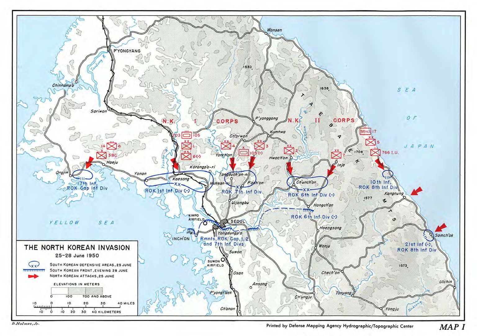
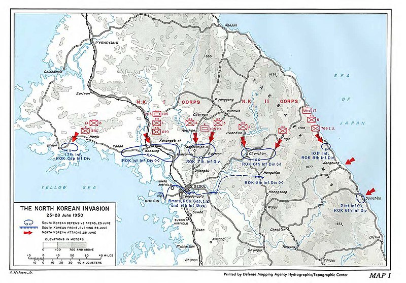
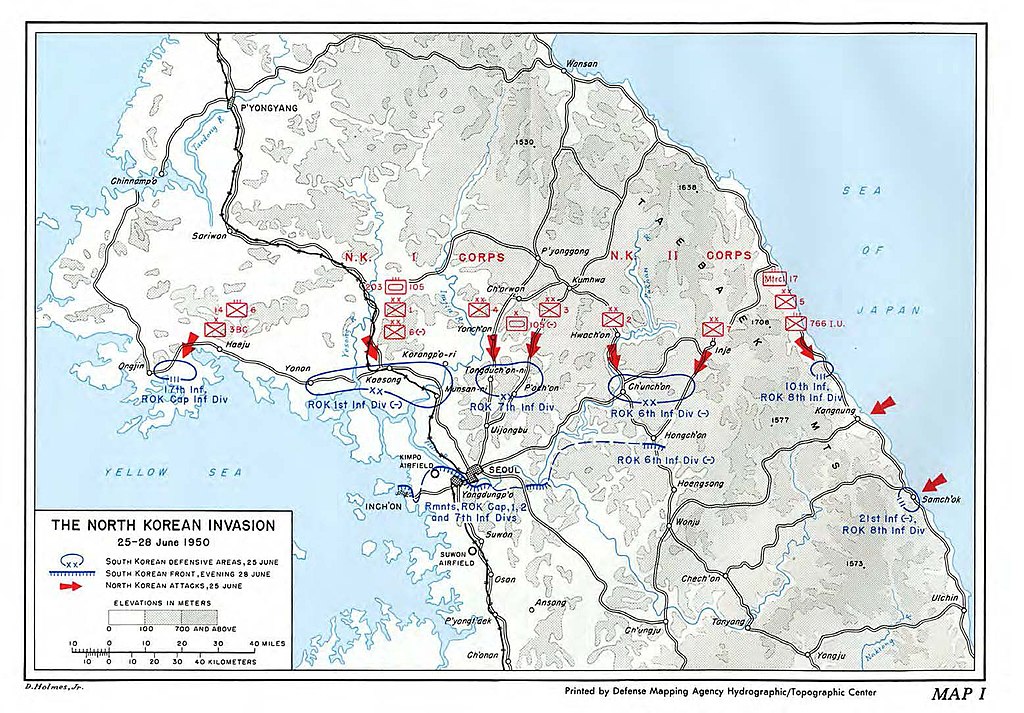
The North Korean Invasion, 25-28 June 1950
파일 설명
[편집]
| 설명 |
English: Map of the North Korean Invasion, 25-28 June 1950 |
| 날짜 | |
| 출처 | South To The Naktong, North To The Yalu - The United States Army in the Korean War, Center of Military History, United States Army, Washington, D.C. |
| 저자 | Roy E. Appleman |
라이선스
[편집]
| This image is in the public domain because it contains materials that originally came from the United States Army Center of Military History, subject to the following qualification.
Note: The images of all badges, insignia, decorations and medals on the "CMH Online" web site are produced by the United States Army Institute of Heraldry and protected by Title 18, United States Code, Section 704 and the Code of Federal Regulations (32 CFR, Part 507). Permission to use these images for commercial purposes must be obtained from The Institute of Heraldry prior to their use. |

|
파일 역사
날짜/시간 링크를 클릭하면 해당 시간의 파일을 볼 수 있습니다.
| 날짜/시간 | 섬네일 | 크기 | 사용자 | 설명 | |
|---|---|---|---|---|---|
| 현재 | 2020년 12월 28일 (월) 22:26 | | 1,556 × 1,084 (250 KB) | Charles Shaulis (토론 | 기여) | Uploaded a work by D. Holmes, Jr. from Reference: South To The Naktong, North To The Yalu - The United States Army in the Korean War, Center of Military History, United States Army, Washington, D.C. with UploadWizard |
이 파일을 덮어쓸 수 없습니다.
이 파일을 사용하는 문서
이 파일을 사용하는 문서가 없습니다.
이 파일을 사용하고 있는 모든 위키의 문서 목록
다음 위키에서 이 파일을 사용하고 있습니다:
- en.wikipedia.org에서 이 파일을 사용하고 있는 문서 목록
- ko.wikipedia.org에서 이 파일을 사용하고 있는 문서 목록
- my.wikipedia.org에서 이 파일을 사용하고 있는 문서 목록
- zh.wikipedia.org에서 이 파일을 사용하고 있는 문서 목록