File:Saola 2005-09-23 0110Z.jpg
둘러보기로 이동
검색으로 이동
미리 보기 크기: 480 × 600 픽셀 다른 해상도: 192 × 240 픽셀 | 384 × 480 픽셀 | 614 × 768 픽셀 | 819 × 1,024 픽셀 | 1,638 × 2,048 픽셀 | 6,400 × 8,000 픽셀
원본 파일 (6,400 × 8,000 픽셀, 파일 크기: 7.77 MB, MIME 종류: image/jpeg)
캡션
설명
이 파일이 나타내는 바에 대한 한 줄 설명을 추가합니다
파일 설명[편집]
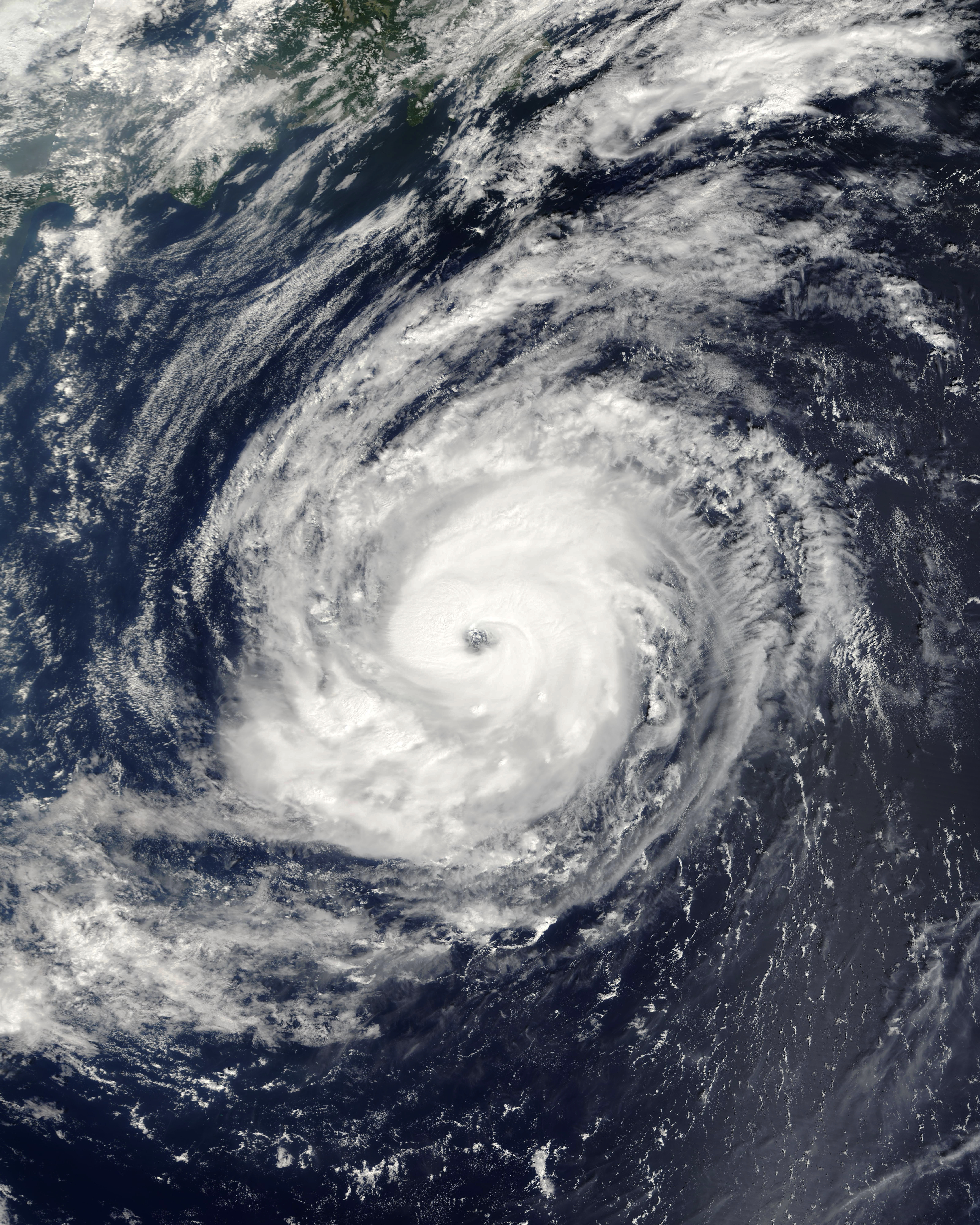
| 설명 | Typhoon Saola formed north of the Marianas Islands on September 20, 2005. It gradually built up power and became a well-organized typhoon with a strong spiral pattern and distinct central eye over the next two days. By the time the Moderate Resolution Imaging Spectroradiometer (MODIS) on NASA’s Terra satellite captured this image of Typhoon Saola at 10:10 a.m. local time on September 23, the storm had sustained wind speeds of 165 kilometers per hour (105 miles per hour). It was located 800 kilometers from Tokyo at the time of the MODIS pass. | |||||
| 날짜 | ||||||
| 출처 | http://earthobservatory.nasa.gov/NaturalHazards/natural_hazards_v2.php3?img_id=13156 | |||||
| 저자 | NASA image created by Jesse Allen, Earth Observatory, using data obtained courtesy of the MODIS Rapid Response team. | |||||
| 저작권 (이 파일을 인용하기) |
|

파일 역사
날짜/시간 링크를 클릭하면 해당 시간의 파일을 볼 수 있습니다.
| 날짜/시간 | 섬네일 | 크기 | 사용자 | 설명 | |
|---|---|---|---|---|---|
| 현재 | 2020년 9월 29일 (화) 15:58 | | 6,400 × 8,000 (7.77 MB) | FleurDeOdile (토론 | 기여) | correct colors |
| 2006년 9월 6일 (수) 22:57 |  | 4,800 × 4,800 (3.75 MB) | Good kitty (토론 | 기여) | == Summary == {{Information |Description=Typhoon Saola formed north of the Marianas Islands on September 20, 2005. It gradually built up power and became a well-organized typhoon with a strong spiral pattern and distinct central eye over the next two days |
이 파일을 덮어쓸 수 없습니다.
이 파일을 사용하는 문서
다음 문서 1개가 이 파일을 사용하고 있습니다:
- File:Typhoon Saola 2005.jpg (파일 넘겨주기)
이 파일을 사용하고 있는 모든 위키의 문서 목록
다음 위키에서 이 파일을 사용하고 있습니다:
- en.wikipedia.org에서 이 파일을 사용하고 있는 문서 목록
- es.wikipedia.org에서 이 파일을 사용하고 있는 문서 목록
- ja.wikipedia.org에서 이 파일을 사용하고 있는 문서 목록
- ko.wikipedia.org에서 이 파일을 사용하고 있는 문서 목록
- pt.wikipedia.org에서 이 파일을 사용하고 있는 문서 목록
- vi.wikipedia.org에서 이 파일을 사용하고 있는 문서 목록
- zh.wikipedia.org에서 이 파일을 사용하고 있는 문서 목록