File:Schengen Area Labelled Map.svg
קפיצה לניווט
קפיצה לחיפוש

גודל התצוגה המקדימה הזאת מסוג PNG של קובץ ה־SVG הזה: 560 × 599 פיקסלים. רזולוציות אחרות: 224 × 240 פיקסלים | 449 × 480 פיקסלים | 718 × 768 פיקסלים | 957 × 1,024 פיקסלים | 1,914 × 2,048 פיקסלים | 645 × 690 פיקסלים.
לקובץ המקורי (קובץ SVG, הגודל המקורי: 645 × 690 פיקסלים, גודל הקובץ: 361 ק"ב)
כיתובים
כיתובים
נא להוסיף משפט שמסביר מה הקובץ מייצג
תקציר
[עריכה]
| תיאור |
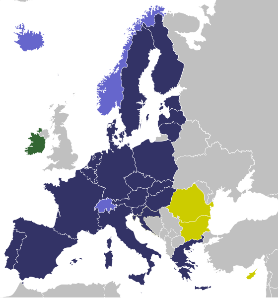
Full Schengen members (EU member states which have implemented the Schengen Agreement) Associated Schengen members (non-EU member states which have implemented the Schengen Agreement) EU member states which are bound to implement the Schengen Agreement but who have not done so yet EU member states outside the Schengen Area |
| תאריך יצירה | (UTC) |
| מקור | |
| יוצר |
|
אני, בעל זכויות היוצרים על עבודה זו, מפרסם בזאת את העבודה תחת הרישיון הבא:
| ברצוני, בעלי זכויות היוצרים על יצירה זו, לשחרר יצירה זו לנחלת הכלל. זה תקף בכל העולם. יש מדינות שבהן הדבר אינו אפשרי על פי חוק, אם כך: אני מעניק לכל אחד את הזכות להשתמש בעבודה זו לכל מטרה שהיא, ללא תנאים כלשהם, אלא אם כן תנאים כאלה נדרשים על פי חוק. |
יומן העלאה מקורי
[עריכה]
This image is a derivative work of the following images:
- File:Schengenzone.svg licensed with PD-self
- 2010-08-07T19:41:47Z Fry1989 645x690 (544009 Bytes) Reverted to version as of 07:59, 18 February 2010 bacl to green, Ireland and UK both apply a few Shengen laws, but are green because they have a seperate border treaty with eachother called the Common Travel Area
- 2010-08-07T15:40:25Z Blue-Haired Lawyer 645x690 (544009 Bytes) Ireland has never ratified Schengen cooperation agreement
- 2010-02-18T07:59:17Z Glentamara 645x690 (544009 Bytes) changed color
- 2009-08-26T01:15:03Z Glentamara 645x690 (544009 Bytes) Switzerland is an associated memeber.
- 2009-08-25T19:15:26Z Mix321 645x690 (544321 Bytes) switzerland
- 2009-08-17T21:35:10Z Glentamara 645x690 (544009 Bytes) new version
- 2009-07-19T18:51:01Z Glentamara 645x690 (544009 Bytes) new colors again
- 2009-07-19T18:39:18Z Glentamara 645x690 (544009 Bytes) New colors
- 2008-12-12T07:32:00Z Glentamara 645x690 (543934 Bytes) Switzerland
- 2008-02-17T16:13:06Z Glentamara 645x690 (543942 Bytes) Kosovo
- 2007-12-21T12:50:56Z Glentamara 645x690 (543975 Bytes)
- 2007-12-21T12:49:13Z Glentamara 645x690 (543975 Bytes) Update.
- 2007-12-07T16:29:12Z Glentamara 645x690 (543970 Bytes) New colors.
- 2007-09-23T10:31:53Z Glentamara 645x690 (543975 Bytes)
- 2007-09-23T08:50:12Z Glentamara 645x690 (543975 Bytes) Ändrar karta så att Schengenområdet bir mer centrerat.
- 2007-05-20T13:25:11Z CrazyPhunk 680x520 (541112 Bytes) {{Information |Description= {{legend|#006BA8|Schengenområdet}} {{legend|#00AAE2|Länder som skrivit under Schengenavtalet}} {{legend|#E2DF00|EU-länder som inte deltar i Schengenavtalet}} |Source=self-made - based upon: [[:I
Uploaded with derivativeFX
היסטוריית הקובץ
ניתן ללחוץ על תאריך/שעה כדי לראות את הקובץ כפי שנראה באותו זמן.
| תאריך/שעה | תמונה ממוזערת | ממדים | משתמש | הערה | |
|---|---|---|---|---|---|
| נוכחית | 13:51, 1 בינואר 2023 | | 690 × 645 (361 ק"ב) | Iktsokh (שיחה | תרומות) | Croatia fix |
| 13:59, 9 בדצמבר 2022 |  | 690 × 645 (349 ק"ב) | Iktsokh (שיחה | תרומות) | Correction of borders | |
| 09:57, 4 בפברואר 2022 |  | 690 × 645 (477 ק"ב) | Jackycheung0929 (שיחה | תרומות) | Brexit | |
| 21:46, 20 בפברואר 2017 |  | 690 × 645 (477 ק"ב) | Nablicus (שיחה | תרומות) | lakes removed | |
| 11:46, 30 ביוני 2013 |  | 690 × 645 (531 ק"ב) | U5K0 (שיחה | תרומות) | croatia to yellow | |
| 01:11, 6 בספטמבר 2011 |  | 690 × 645 (531 ק"ב) | Blue-Haired Lawyer (שיחה | תרומות) | Republic of Ireland now coloured green to go with altered legend | |
| 01:48, 8 באוגוסט 2010 |  | 690 × 645 (531 ק"ב) | Blue-Haired Lawyer (שיחה | תרומות) | {{Information |Description={{legend|#333366|Fully Schengen members (EU member states which have implemented the Schengen Agreement)}} {{legend|#6666CC|Associated Schengen members (non-EU member states which have implemented the Schengen Agreement)}} {{leg |
אין באפשרותך לדרוס את הקובץ הזה.
שימוש בקובץ
הדף הבא משתמש בקובץ הזה:
שימוש גלובלי בקובץ
אתרי הוויקי השונים הבאים משתמשים בקובץ זה:
- שימוש באתר ar.wikipedia.org
- שימוש באתר de.wikipedia.org
- שימוש באתר en.wikipedia.org
- שימוש באתר he.wikipedia.org
- שימוש באתר id.wikipedia.org
- שימוש באתר ml.wikipedia.org
- שימוש באתר ms.wikipedia.org
- שימוש באתר pl.wikipedia.org
- שימוש באתר vi.wikipedia.org