File:South lebanon Qana locator map.png

לקובץ המקורי (827 × 615 פיקסלים, גודל הקובץ: 58 ק"ב, סוג MIME: image/png)
כיתובים
כיתובים
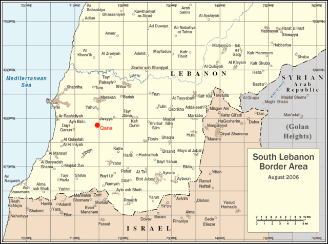
| תיאור | Locator map for Qana, Lebanon |
| תאריך יצירה | |
| מקור | Uploaded as en:Image:South lebanon map qana.png on August 5 2006 |
| יוצר | Original map courtesy of the United Nations. Modifications by en:User:ChrisO. |
| אישורים והיתרים (שימוש חוזר בקובץ זה) |
PD |
| This image is a map derived from a United Nations map.
Unless stated otherwise, UN maps are to be considered in the public domain. This applies worldwide. UN maps are, in principle, open source material and you can use them in your work or for making your own map. UN requests however that you delete the UN name, logo and reference number upon any modification to the map. Content of your map will be your responsibility. You can state in your publication, if you wish, something like: based on UN map … (map name, map number, revision number and date). See: Geospatial Information Section. And: Geospatial, location data for a better world. |
 |
| |
תמונה זו שוחררה לרשות הציבור על ידי היוצר שלה, ChrisO במיזם Wikimedia Commons. זה תקף בכל העולם. במקרה ששחרור לרשות הציבור לא אפשרי מבחינה חוקית: |
היסטוריית הקובץ
ניתן ללחוץ על תאריך/שעה כדי לראות את הקובץ כפי שנראה באותו זמן.
| תאריך/שעה | תמונה ממוזערת | ממדים | משתמש | הערה | |
|---|---|---|---|---|---|
| נוכחית | 03:40, 8 באוגוסט 2006 | | 615 × 827 (58 ק"ב) | Jkelly (שיחה | תרומות) | {{Information |Description=Locator map for Qana, Lebanon |Source=Uploaded as en:Image:South lebanon map qana.png on August 5 2006 |Date=August 5 2006 |Author=Original map courtesy of the United Nations. Modifications by [ |
אין באפשרותך לדרוס את הקובץ הזה.
שימוש בקובץ
הדפים הבאים משתמשים בקובץ הזה:
שימוש גלובלי בקובץ
אתרי הוויקי השונים הבאים משתמשים בקובץ זה:
- שימוש באתר ar.wikipedia.org
- שימוש באתר arz.wikipedia.org
- שימוש באתר ca.wikipedia.org
- שימוש באתר de.wikipedia.org
- שימוש באתר en.wikipedia.org
- שימוש באתר eo.wikipedia.org
- שימוש באתר es.wikipedia.org
- שימוש באתר fy.wikipedia.org
- שימוש באתר he.wikipedia.org
- שימוש באתר id.wikipedia.org
- שימוש באתר ja.wikipedia.org
- שימוש באתר no.wikipedia.org
- שימוש באתר pl.wikipedia.org
- שימוש באתר tr.wikipedia.org
- שימוש באתר www.wikidata.org