File:Southwest Indian Ridge ETOPO1.png
קפיצה לניווט
קפיצה לחיפוש

גודל התצוגה המקדימה הזאת: 627 × 600 פיקסלים. רזולוציות אחרות: 251 × 240 פיקסלים | 502 × 480 פיקסלים | 803 × 768 פיקסלים | 1,255 × 1,200 פיקסלים.
לקובץ המקורי (1,255 × 1,200 פיקסלים, גודל הקובץ: 2.7 מ"ב, סוג MIME: image/png)
כיתובים
כיתובים
נא להוסיף משפט שמסביר מה הקובץ מייצג
תקציר
[עריכה]
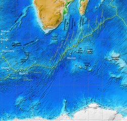
| תיאור | Map of the Southwest Indian Ridge. White dots–hotspots; yellow dashed lines–major fracture zones. Incomplete work in progress (bbl). |
| תאריך יצירה | |
| מקור |
NOAA ETOPO1, additions from Georgen et al. 2001, Fig. 1 made in Inkscape.
|
| יוצר | NOAA, additions by Fama Clamosa (שיחה) 09:04, 31 July 2016 (UTC) |
| אישורים והיתרים (שימוש חוזר בקובץ זה) |
PD-USGov |
רישיון
[עריכה]
This image is in the public domain because it contains materials that originally came from the U.S. National Oceanic and Atmospheric Administration, taken or made as part of an employee's official duties.
|
היסטוריית הקובץ
ניתן ללחוץ על תאריך/שעה כדי לראות את הקובץ כפי שנראה באותו זמן.
| תאריך/שעה | תמונה ממוזערת | ממדים | משתמש | הערה | |
|---|---|---|---|---|---|
| נוכחית | 09:56, 31 ביולי 2016 | | 1,200 × 1,255 (2.7 מ"ב) | Fama Clamosa (שיחה | תרומות) | Reverted to version as of 09:51, 31 July 2016 (UTC) |
| 09:53, 31 ביולי 2016 |  | 1,200 × 1,255 (2.7 מ"ב) | Fama Clamosa (שיחה | תרומות) | try again | |
| 09:51, 31 ביולי 2016 |  | 1,200 × 1,255 (2.7 מ"ב) | Fama Clamosa (שיחה | תרומות) | Labels corrected and added. | |
| 09:04, 31 ביולי 2016 |  | 1,200 × 1,255 (2.69 מ"ב) | Fama Clamosa (שיחה | תרומות) | {{Information |Description=Map of the Southwest Indian Ridge. White dots–hotspots; yellow dashed lines–major fracture zones. Incomplete work in progress (bbl). |Source=[http://maps.ngdc.noaa.gov/viewers/wcs-client/ NOAA ETOPO1], additions made in I... |
אין באפשרותך לדרוס את הקובץ הזה.
שימוש בקובץ
אין דפים המשתמשים בקובץ זה.
שימוש גלובלי בקובץ
אתרי הוויקי השונים הבאים משתמשים בקובץ זה:
- שימוש באתר ca.wikipedia.org
- שימוש באתר de.wikipedia.org
- שימוש באתר en.wikipedia.org
- שימוש באתר es.wikipedia.org
- שימוש באתר he.wikipedia.org
- שימוש באתר hr.wikipedia.org
- שימוש באתר it.wikipedia.org
- שימוש באתר ja.wikipedia.org
- שימוש באתר pl.wikipedia.org
- שימוש באתר ru.wikipedia.org
- שימוש באתר sr.wikipedia.org
- שימוש באתר sw.wikipedia.org
- שימוש באתר zh-yue.wikipedia.org