File:Survey of Palestine, Jerusalem 06-III-F (FL191853714 2367708).jpg
קפיצה לניווט
קפיצה לחיפוש

גודל התצוגה המקדימה הזאת: 552 × 599 פיקסלים. רזולוציות אחרות: 221 × 240 פיקסלים | 442 × 480 פיקסלים | 707 × 768 פיקסלים | 943 × 1,024 פיקסלים | 1,886 × 2,048 פיקסלים | 14,499 × 15,743 פיקסלים.
לקובץ המקורי (14,499 × 15,743 פיקסלים, גודל הקובץ: 197.87 מ"ב, סוג MIME: image/jpeg)
כיתובים
כיתובים
נא להוסיף משפט שמסביר מה הקובץ מייצג
תקציר
[עריכה]| Jerusalem
( |
||||||||||||||||||||||||
|---|---|---|---|---|---|---|---|---|---|---|---|---|---|---|---|---|---|---|---|---|---|---|---|---|
| אומן |
|
|||||||||||||||||||||||
| כותרת |
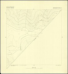
Jerusalem |
|||||||||||||||||||||||
| מפרסם |
Survey of Egypt |
|||||||||||||||||||||||
| תיאור |
Jerusalem. Survey of Palestine. |
|||||||||||||||||||||||
| שפה | אנגלית | |||||||||||||||||||||||
| תאריך הוצאה לאור | 1925 | |||||||||||||||||||||||
| אוסף |
|
|||||||||||||||||||||||
| מיקום נוכחי |
|
|||||||||||||||||||||||
| מיקום הוצאה | יפו | |||||||||||||||||||||||
| חיפוש בקטלוג מרחב | יפו | |||||||||||||||||||||||
| הערות |
Surveyed in 1921-1922, additions 1924, Survey of Palestine, Jaffa, Jan. 1925, Printed by the Survey of Egypt; Link to Digital version of map in Albright Institue: https://aiar.userservices.exlibrisgroup.com/view/delivery/972AI_INST/127799590002696 List: [V-D, V-E, V-F, V-G, VI-D, VI-E, VI-F, VI-G, VII-D, VII-E, VII-G Photography by Ardon Bar-Hama courtesy of George Blumenthal; VII-F © Hebrew University in Jerusalem]; כולל סימון מגדל שעון בכיכר אלנבי [=כיכר צהל].;$aSheet V-D Princess house [Jeanne Merkus]. English: Jerusalem. 1:2,000 | |||||||||||||||||||||||
| קנה מידה | 1:2,000 cm | |||||||||||||||||||||||
| IE PID | IE191853706 | |||||||||||||||||||||||
| רוזטה שם קובץ | FL191853714 | |||||||||||||||||||||||
| מזהה רשומה בספרייה הלאומית (P3959) | 990023677080205171 | |||||||||||||||||||||||
| חיפוש בקטלוג מרחב | אנגלית, המרכז למיפוי ארץ ישראל | |||||||||||||||||||||||
| חיפוש בקטלוג מרחב | Survey of Egypt | |||||||||||||||||||||||
| מקור/צלם |
|
|||||||||||||||||||||||
| גרסאות אחרות | ||||||||||||||||||||||||
| Jpg / Tif version |
|
|||||||||||||||||||||||

.jpg)

.jpg&action=edit§ion=1)
רישיון
[עריכה].jpg&action=edit§ion=2)
This work was published before January 1, 1926 and it is anonymous or pseudonymous due to unknown authorship. It is in the public domain in the United States as well as countries and areas where the copyright terms of anonymous or pseudonymous works are 98 years or fewer since publication.
|
היסטוריית הקובץ
ניתן ללחוץ על תאריך/שעה כדי לראות את הקובץ כפי שנראה באותו זמן.
| תאריך/שעה | תמונה ממוזערת | ממדים | משתמש | הערה | |
|---|---|---|---|---|---|
| נוכחית | 19:07, 30 ביולי 2023 | | 15,743 × 14,499 (197.87 מ"ב) | Geagea (שיחה | תרומות) | pattypan 22.03 |
אין באפשרותך לדרוס את הקובץ הזה.
שימוש בקובץ
הדף הבא משתמש בקובץ הזה:
.jpg&oldid=794721039)