File:Swisstopo 2.jpg
둘러보기로 이동
검색으로 이동
미리 보기 크기: 600 × 600 픽셀 다른 해상도: 240 × 240 픽셀 | 480 × 480 픽셀
원본 파일 (800 × 800 픽셀, 파일 크기: 623 KB, MIME 종류: image/jpeg)
캡션
설명
이 파일이 나타내는 바에 대한 한 줄 설명을 추가합니다
파일 설명[편집]
| 묘사 |
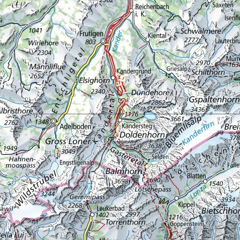
English: 1:500'000 topographic map of Kandersteg (centered on the main church's bell tower). Made by the Federal Office of Topography (swisstopo). Nota bene: this picture is part of a series showing all 7 different scales of the National Map of Switzerland. Full version can be consulted on the geographical portal. |
|||||||||||||||||||||||
| 날짜 | ||||||||||||||||||||||||
| 출처 | Swisstopo maps on the geographical portal | |||||||||||||||||||||||
| 창작자 |
|
|||||||||||||||||||||||
| 지리 정보 | ||||||||||||||||||||||||
| 지도 위치 | Kandersteg, Kandertal; Adelboden | |||||||||||||||||||||||
| 축척 | 1:500,000 | |||||||||||||||||||||||
| 표제 |
 |
|||||||||||||||||||||||
| 영역 상자 |
|
|||||||||||||||||||||||
| 다른 버전 |
Kandersteg on Swisstopo maps
for comparison
|
|||||||||||||||||||||||


| 대상 위치 | | 이 지역의 다른 사진을 보기: OpenStreetMap |
|---|
라이선스[편집]
The data made publicly available by swisstopo may be used, distributed and made accessible. Furthermore, they may be enriched and processed and also used commercially. A reference to the source is mandatory. In the case of digital or analogue representations and publications, as well as in the case of dissemination, one of the following source references must be attached in any case:
Terms of use for free geodata and geoservices (OGD) from swisstopo
|
.svg) |
파일 역사
날짜/시간 링크를 클릭하면 해당 시간의 파일을 볼 수 있습니다.
| 날짜/시간 | 섬네일 | 크기 | 사용자 | 설명 | |
|---|---|---|---|---|---|
| 현재 | 2021년 3월 22일 (월) 15:09 | | 800 × 800 (623 KB) | Zacharie Grossen (토론 | 기여) | Uploaded a work by Bundesamt für Landestopografie swisstopo from [https://map.geo.admin.ch/ Swisstopo maps on the geographical portal] with UploadWizard |
이 파일을 덮어쓸 수 없습니다.
이 파일을 사용하는 문서
다음 문서 12개가 이 파일을 사용하고 있습니다:
- File:Kandersteg (from Swisstopo Dufourkarte 100000 BLATT XVII, LT TK 017 1844).tiff
- File:Kandersteg (from Swisstopo Skiroutenkarte Wildstrubel 50000, LT LK 263 S 1955).tiff
- File:National Map of Switzerland.jpg
- File:Swisstopo 1.jpg
- File:Swisstopo 2.jpg
- File:Swisstopo 3.jpg
- File:Swisstopo 4.jpg
- File:Swisstopo 5.jpg
- File:Swisstopo 6.jpg
- File:Swisstopo 7.jpg
- File:Swisstopo 8.jpg
- Template:Swisstopo Kandersteg comparison
이 파일을 사용하고 있는 모든 위키의 문서 목록
다음 위키에서 이 파일을 사용하고 있습니다:
- de.wikipedia.org에서 이 파일을 사용하고 있는 문서 목록
- en.wikipedia.org에서 이 파일을 사용하고 있는 문서 목록
- ko.wikipedia.org에서 이 파일을 사용하고 있는 문서 목록