File:Syria and Lebanon (FL155322793 2515041).jpg
קפיצה לניווט
קפיצה לחיפוש

גודל התצוגה המקדימה הזאת: 788 × 599 פיקסלים. רזולוציות אחרות: 316 × 240 פיקסלים | 631 × 480 פיקסלים | 1,010 × 768 פיקסלים | 1,280 × 974 פיקסלים | 2,560 × 1,947 פיקסלים | 14,669 × 11,157 פיקסלים.
לקובץ המקורי (14,669 × 11,157 פיקסלים, גודל הקובץ: 182.18 מ"ב, סוג MIME: image/jpeg)
כיתובים
כיתובים
נא להוסיף משפט שמסביר מה הקובץ מייצג
תקציר
[עריכה]| Syria and Lebanon
( |
||||||||||||||||||||||||
|---|---|---|---|---|---|---|---|---|---|---|---|---|---|---|---|---|---|---|---|---|---|---|---|---|
| כותרת |
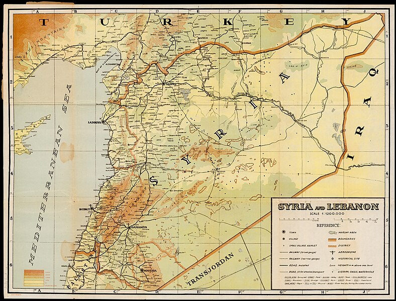
Syria and Lebanon |
|||||||||||||||||||||||
| תיאור |
Syria and Lebanon. |
|||||||||||||||||||||||
| שפה | אנגלית | |||||||||||||||||||||||
| תאריך הוצאה לאור | 1930 ייתכן | |||||||||||||||||||||||
| טכניקה | 1 map : col ; | |||||||||||||||||||||||
| ממדים | גובה: 44 ס"מ; רוחב: 59 ס"מ | |||||||||||||||||||||||
| אוסף |
|
|||||||||||||||||||||||
| מיקום נוכחי |
|
|||||||||||||||||||||||
| מיקום הוצאה | קהיר | |||||||||||||||||||||||
| הערות | מפה פיזית | |||||||||||||||||||||||
| קנה מידה | 1:1,200,000 cm | |||||||||||||||||||||||
| IE PID | IE155322790 | |||||||||||||||||||||||
| רוזטה שם קובץ | FL155322793 | |||||||||||||||||||||||
| מזהה רשומה בספרייה הלאומית (P3959) | 990025150410205171 | |||||||||||||||||||||||
| מוצג | סוריה ולבנון | |||||||||||||||||||||||
| חיפוש בקטלוג מרחב | סוריה, לבנון, אנגלית, קהיר | |||||||||||||||||||||||
| חיפוש בקטלוג מרחב | LebanonSyriaPhysical maps | |||||||||||||||||||||||
| מקור/צלם |
|
|||||||||||||||||||||||
| גרסאות אחרות | ||||||||||||||||||||||||
| Jpg / Tif version |
|
|||||||||||||||||||||||

.jpg)

.jpg&action=edit§ion=1)
רישיון
[עריכה].jpg&action=edit§ion=2)
This UK artistic or literary work, of which the author is unknown and cannot be ascertained by reasonable enquiry, is in the public domain because it is one of the following:
|
 |
היסטוריית הקובץ
ניתן ללחוץ על תאריך/שעה כדי לראות את הקובץ כפי שנראה באותו זמן.
| תאריך/שעה | תמונה ממוזערת | ממדים | משתמש | הערה | |
|---|---|---|---|---|---|
| נוכחית | 23:12, 7 באוגוסט 2023 | | 11,157 × 14,669 (182.18 מ"ב) | Geagea (שיחה | תרומות) | c:User:Rillke/bigChunkedUpload.js: =={{int:filedesc}}== {{Artwork |artist = |author = |title = Syria and Lebanon |description = Syria and Lebanon. |language = {{Label|1=Q1860}} |date = |publication date = 1930 {{Label|1=Q30230067}} |medium = 1 map : col ; |dimensions = {{size|cm|44|59}} |institution = {{Institution:Eran Laor Cartographic Collection}} |department = {{Institution:National Library of Israel}} |place of publication = {{Label|1=Q85}} |object history = |exhib... |
אין באפשרותך לדרוס את הקובץ הזה.
שימוש בקובץ
הדפים הבאים משתמשים בקובץ הזה:
.jpg&oldid=803405626)