File:The description of the Holy Land, containing the places mentioned in the foure Evangelists (FL169299344 3960419).jpg
קפיצה לניווט
קפיצה לחיפוש

גודל התצוגה המקדימה הזאת: 755 × 600 פיקסלים. רזולוציות אחרות: 302 × 240 פיקסלים | 604 × 480 פיקסלים | 967 × 768 פיקסלים | 1,280 × 1,017 פיקסלים | 2,560 × 2,034 פיקסלים | 5,070 × 4,029 פיקסלים.
לקובץ המקורי (5,070 × 4,029 פיקסלים, גודל הקובץ: 23.97 מ"ב, סוג MIME: image/jpeg)
כיתובים
כיתובים
נא להוסיף משפט שמסביר מה הקובץ מייצג
תקציר
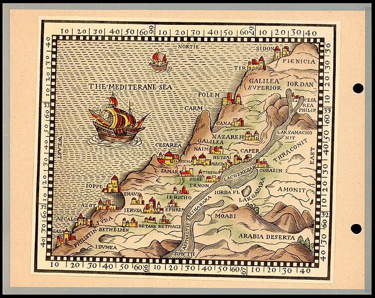
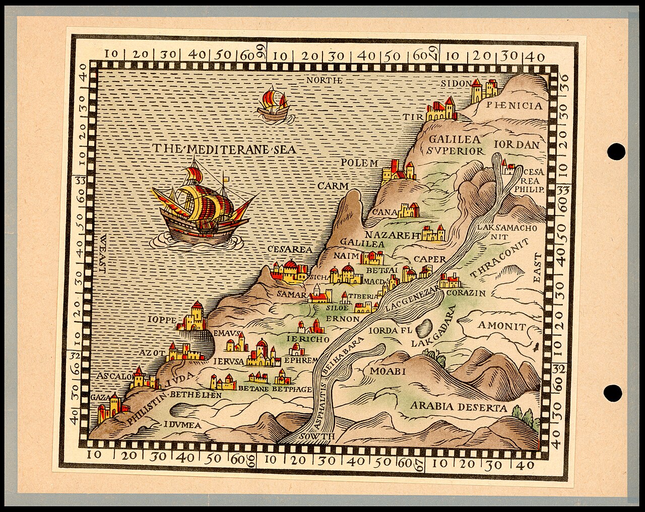
[עריכה]| The description of the Holy Land, containing the places mentioned in the foure Evangelists
( |
||||||||||||||||||||||||
|---|---|---|---|---|---|---|---|---|---|---|---|---|---|---|---|---|---|---|---|---|---|---|---|---|
| אומן |
| |||||||||||||||||||||||
| יוצרים נוספים | Postel, Guillaume, 1510-1581 | |||||||||||||||||||||||
| כותרת |
The description of the Holy Land, containing the places mentioned in the foure Evangelists |
|||||||||||||||||||||||
| מפרסם |
Universitas Booksellers |
|||||||||||||||||||||||
| תיאור |
The description of the Holy Land, containing the places mentioned in the foure Evangelists.. |
|||||||||||||||||||||||
| שפה | אנגלית | |||||||||||||||||||||||
| תאריך הוצאה לאור | 1956 | |||||||||||||||||||||||
| טכניקה | 1 folder (map and text page) : color ; | |||||||||||||||||||||||
| ממדים | 15 × 17 ס"מ (map) | |||||||||||||||||||||||
| אוסף |
|
|||||||||||||||||||||||
| מיקום נוכחי |
|
|||||||||||||||||||||||
| מיקום הוצאה | ירושלים | |||||||||||||||||||||||
| חיפוש בקטלוג מרחב | ירושלים | |||||||||||||||||||||||
| הערות | Reproduction of Pal 976, colored, with printed page The land of the Bible in Roman times woodcut, London, 1576. Published in Jerusalem by Universitas, 1956.; Probably drawn after Guillaume Postel's map. | |||||||||||||||||||||||
| IE PID | IE169299342 | |||||||||||||||||||||||
| רוזטה שם קובץ | FL169299344 | |||||||||||||||||||||||
| מזהה רשומה בספרייה הלאומית (P3959) | 990039604190205171 | |||||||||||||||||||||||
| חיפוש בקטלוג מרחב | אנגלית | |||||||||||||||||||||||
| חיפוש בקטלוג מרחב | Universitas Booksellers | |||||||||||||||||||||||
| מקור/צלם |
|
|||||||||||||||||||||||
| גרסאות אחרות | ||||||||||||||||||||||||
| Jpg / Tif version |
|
|||||||||||||||||||||||

.jpg)

.jpg&action=edit§ion=1)
רישיון
[עריכה].jpg&action=edit§ion=2)
The copyright situation of this work is theoretically uncertain, because in the country of origin copyright lasts 70 years after the death of the author, and the date of the author's death is unknown. However, the date of creation of the work was over 120 years ago, and it is thus a reasonable assumption that the copyright has expired (see here for the community discussion). Do not use this template if the date of death of the author is known.
| |
| הקובץ הזה זוהה כקובץ חופשי מכל מגבלה ידועה תחת חוק זכויות היוצרים, כולל כל הזכויות הקשורות והסמוכות. | |
היסטוריית הקובץ
ניתן ללחוץ על תאריך/שעה כדי לראות את הקובץ כפי שנראה באותו זמן.
| תאריך/שעה | תמונה ממוזערת | ממדים | משתמש | הערה | |
|---|---|---|---|---|---|
| נוכחית | 06:20, 26 ביולי 2023 | | 4,029 × 5,070 (23.97 מ"ב) | Geagea (שיחה | תרומות) | pattypan 22.03 |
אין באפשרותך לדרוס את הקובץ הזה.
שימוש בקובץ
הדף הבא משתמש בקובץ הזה:
.jpg&oldid=786899553)