File:The origin and spread of the Sino-Tibetan language family.png

원본 파일 (2,851 × 1,910 픽셀, 파일 크기: 6.57 MB, MIME 종류: image/png)
캡션
설명
파일 설명
[편집]
| 설명 |
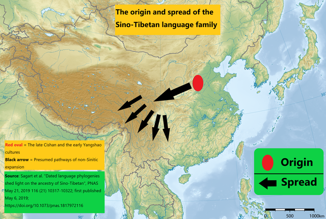
English: Despite its importance, many studies have not been conducted on the Sino-Tibetan languages, so there have been many questions and debates about the origin and spread route. So in 2019, Laurent Sagart and other researchers used the latest scientific techniques based on the newly developed database to derive the origin and spread route of the Sino-Tibetan languages.
1. Researchers develop a database of comparative linguistic data, and apply the linguistic comparative method to identify sound correspondences and establish cognates. 2. Researchers use phylogenetic methods to infer the relationships among these languages and estimate the age of their origin and homeland. 3. Reserchers concluded that Sino-Tibetan originated with north Chinese millet farmers around 7200 B.P. and suggest a link to the late Cishan and the early Yangshao cultures. Red oval = "the late Cishan and the early Yangshao cultures" Black arrow = "presumed pathways of non-Sinitic expansion" Research papers: https://www.pnas.org/content/116/21/10317 (In particular, Fig. 1.) |
| 날짜 | |
| 출처 | https://upload.wikimedia.org/wikipedia/commons/2/26/East_Asia_topographic_map.png |
| 저자 | Ksiom, Abooop |
라이선스
[편집]
- 이용자는 다음의 권리를 갖습니다:
- 공유 및 이용 – 저작물의 복제, 배포, 전시, 공연 및 공중송신
- 재창작 – 저작물의 개작, 수정, 2차적저작물 창작
- 다음과 같은 조건을 따라야 합니다:
- 저작자표시 – 적절한 저작자 표시를 제공하고, 라이센스에 대한 링크를 제공하고, 변경사항이 있는지를 표시해야 합니다. 당신은 합리적인 방식으로 표시할 수 있지만, 어떤 방식으로든 사용권 허가자가 당신 또는 당신의 사용을 지지하는 방식으로 표시할 수 없습니다.
- 동일조건변경허락 – 만약 당신이 이 저작물을 리믹스 또는 변형하거나 이 저작물을 기반으로 제작하는 경우, 당신은 당신의 기여물을 원저작물과 동일하거나 호환 가능한 라이선스에 따라 배포하여야 합니다.
파일 역사
날짜/시간 링크를 클릭하면 해당 시간의 파일을 볼 수 있습니다.
| 날짜/시간 | 섬네일 | 크기 | 사용자 | 설명 | |
|---|---|---|---|---|---|
| 현재 | 2021년 10월 15일 (금) 09:20 | | 2,851 × 1,910 (6.57 MB) | Abooop (토론 | 기여) | Add description |
| 2021년 10월 14일 (목) 23:11 |  | 2,851 × 1,910 (6.93 MB) | Abooop (토론 | 기여) | Uploaded a work by Ksiom from https://upload.wikimedia.org/wikipedia/commons/2/26/East_Asia_topographic_map.png with UploadWizard |
이 파일을 덮어쓸 수 없습니다.
이 파일을 사용하는 문서
다음 문서 1개가 이 파일을 사용하고 있습니다:
이 파일을 사용하고 있는 모든 위키의 문서 목록
다음 위키에서 이 파일을 사용하고 있습니다:
- bo.wikipedia.org에서 이 파일을 사용하고 있는 문서 목록
- de.wikipedia.org에서 이 파일을 사용하고 있는 문서 목록
- en.wikipedia.org에서 이 파일을 사용하고 있는 문서 목록
- es.wikipedia.org에서 이 파일을 사용하고 있는 문서 목록
- fr.wikipedia.org에서 이 파일을 사용하고 있는 문서 목록
- id.wikipedia.org에서 이 파일을 사용하고 있는 문서 목록
- nl.wikipedia.org에서 이 파일을 사용하고 있는 문서 목록
- pt.wikipedia.org에서 이 파일을 사용하고 있는 문서 목록
- ru.wikipedia.org에서 이 파일을 사용하고 있는 문서 목록
- uk.wikipedia.org에서 이 파일을 사용하고 있는 문서 목록
- zh.wikipedia.org에서 이 파일을 사용하고 있는 문서 목록