File:Tropical wet forests.svg

לקובץ המקורי (קובץ SVG, הגודל המקורי: 1,052 × 523 פיקסלים, גודל הקובץ: 7.7 מ"ב)
כיתובים
כיתובים
תקציר
[עריכה]
| תיאור |
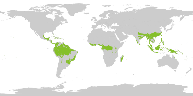
English: Tropical wet forests. The humid tropical biome was delineated using the World Wildlife Fund terrestrial ecoregions map. This map was modified to exclude mountain and coastal forest mosaic ecoregions in Africa.
Français : Forêts tropicales humides. |
| תאריך יצירה | |
| מקור | נוצר על־ידי מעלה היצירה |
| יוצר | Yerachmiel C |
רישיון
[עריכה]
- יש לך חופש:
- לשתף – להעתיק, להפיץ ולהעביר את העבודה
- לערבב בין עבודות – להתאים את העבודה
- תחת התנאים הבאים:
- ייחוס – יש לתת ייחוס הולם, לתת קישור לרישיון, ולציין אם נעשו שינויים. אפשר לעשות את זה בכל צורה סבירה, אבל לא בשום צורה שמשתמע ממנה שמעניק הרישיון תומך בך או בשימוש שלך.
- שיתוף זהה – יצירת רמיקס, שינוי או בנייה על סמך החומר הזה, תטיל עליך חובה להפיץ את התרומות שלך לפי תנאי רישיון זהה או תואם למקור.
Map uses following sources:
"Biome boundary. The humid tropical biome was delineated using the World Wildlife Fund terrestrial ecoregions map. This map was modified to exclude mountain and coastal forest mosaic ecoregions in Africa." on Global Forest Monitoring Project
Original data licensed as:
"Provided data are available for use for valid scientific, conservation, and educational purposes as long as proper citations are used. We ask that you credit the Humid Tropical Monitoring data as follows: Hansen, M.C., Stehman, S.V., Potapov, P.V., Loveland, T.R., Townshend, J.R.G., DeFries, R.S., Pittman, K.W., Stolle, F., Steininger, M.K., Carroll, M., Dimiceli, C. (2008) Humid tropical forest clearing from 2000 to 2005 quantified using multi-temporal and multi-resolution remotely sensed data. PNAS, 105(27), 9439-9444."
Shapefile of forests:
- By Geographic Information Science Center of Excellence (GIScCE) - SDSU [1] ;
World map with national country outlines and border:
היסטוריית הקובץ
ניתן ללחוץ על תאריך/שעה כדי לראות את הקובץ כפי שנראה באותו זמן.
| תאריך/שעה | תמונה ממוזערת | ממדים | משתמש | הערה | |
|---|---|---|---|---|---|
| נוכחית | 16:20, 27 באוגוסט 2022 | | 523 × 1,052 (7.7 מ"ב) | Yerachmiel C (שיחה | תרומות) | reduce stroke around country borders |
| 16:10, 27 באוגוסט 2022 |  | 523 × 1,052 (7.76 מ"ב) | Yerachmiel C (שיחה | תרומות) | fix | |
| 15:17, 27 באוגוסט 2022 |  | 523 × 1,052 (7.9 מ"ב) | Yerachmiel C (שיחה | תרומות) | Uploaded own work with UploadWizard |
אין באפשרותך לדרוס את הקובץ הזה.
שימוש בקובץ
הדפים הבאים משתמשים בקובץ הזה:
שימוש גלובלי בקובץ
אתרי הוויקי השונים הבאים משתמשים בקובץ זה:
- שימוש באתר en.wikipedia.org
- שימוש באתר en.wikibooks.org
- שימוש באתר fr.wikipedia.org
- שימוש באתר he.wikipedia.org
- שימוש באתר uk.wikipedia.org