File:WW2-Holocaust-Europe-2007Borders DE.png
קפיצה לניווט
קפיצה לחיפוש

גודל התצוגה המקדימה הזאת: 721 × 600 פיקסלים. רזולוציות אחרות: 289 × 240 פיקסלים | 577 × 480 פיקסלים | 923 × 768 פיקסלים | 1,231 × 1,024 פיקסלים | 1,310 × 1,090 פיקסלים.
לקובץ המקורי (1,310 × 1,090 פיקסלים, גודל הקובץ: 572 ק"ב, סוג MIME: image/png)
כיתובים
כיתובים
נא להוסיף משפט שמסביר מה הקובץ מייצג
| תיאור |
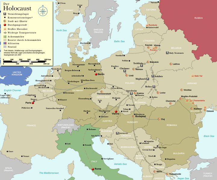
English: Map (with German legend) of the Holocaust in Europe during World War II, 1939-1945. This map shows all German Nazi extermination camps (or death camps), most major concentration camps, labor camps, prison camps, ghettos, major deportation routes and major massacre sites. Please note that a version with 1942 borders is available here: Image:WW2-Holocaust-Europe.png. Notes: 1. Extermination camps were dedicated death camps, but all camps and ghettos took a toll of many, many lives. 2. Concentration camps include labor camps, prison camps & transit camps. 3. Not all camps & ghettos are shown. 4. Borders are present borders (2007). |
| תאריך יצירה | (UTC) |
| מקור | |
| יוצר |
|
| גרסאות אחרות |
[]
|


.png)


.png)


| זוהי תמונה מרוטשת, זאת אומרת שהתמונה שונתה בצורה דיגיטלית מהמקור. Modifications: legend and title now german. את התמונה המקורית ניתן לראות ב: WW2-Holocaust-Europe-2007Borders.png. השינוי בוצע על ידי Emdee.
|
אני, בעל זכויות היוצרים על עבודה זו, מפרסם בזאת את העבודה תחת הרישיון הבא:
הקובץ הזה מתפרסם לפי תנאי רישיון קריאייטיב קומונז ייחוס 3.0 לא מותאם.
- הנכם רשאים:
- לשתף – להעתיק, להפיץ ולהעביר את העבודה
- לערבב בין עבודות – להתאים את העבודה
- תחת התנאים הבאים:
- ייחוס – יש לתת ייחוס הולם, לתת קישור לרישיון, ולציין אם נעשו שינויים. אפשר לעשות את זה בכל צורה סבירה, אבל לא בשום צורה שמשתמע ממנה שמעניק הרישיון תומך בך או בשימוש שלך.

|
יש ליצור מחדש את התמונה historical map הזו באמצעות גרפיקה וקטורית כדוגמת קובץ SVG. לפעולה זו מספר יתרונות, כפי שניתן לקרוא (באנגלית) בדף Commons:Media for cleanup. אם ברשותכם קובץ SVG, אנא העלו אותו. לאחר מכן, החליפו תבנית זו בתבנית
{{vector version available|שם הקובץ.svg}} |
יומן העלאה מקורי[עריכה]
This image is a derivative work of the following images:
- File:WW2-Holocaust-Europe-2007Borders.png licensed with Cc-by-3.0
- 2007-12-17T10:40:36Z Dna-webmaster 1310x1090 (785571 Bytes) == Summary == {{Information |Description=Map of the Holocaust in Europe during World War II, 1939-1945. This map shows all extermination camps (or ''death camps''), most major concentration camps, labor camps, prison camps,
Uploaded with derivativeFX
היסטוריית הקובץ
ניתן ללחוץ על תאריך/שעה כדי לראות את הקובץ כפי שנראה באותו זמן.
| תאריך/שעה | תמונה ממוזערת | ממדים | משתמש | הערה | |
|---|---|---|---|---|---|
| נוכחית | 19:01, 2 בנובמבר 2009 | | 1,090 × 1,310 (572 ק"ב) | Flying Saucer (שיחה | תרומות) | Vaivara correction |
| 20:59, 21 ביולי 2009 |  | 1,090 × 1,310 (760 ק"ב) | Emdee (שיחה | תרומות) | legende: Allierte (typo!) -> Alliierten (plural) Große Transportroute -> Wichtige Transportroute | |
| 16:07, 21 ביולי 2009 |  | 1,090 × 1,310 (760 ק"ב) | Emdee (שיחה | תרומות) | {{Information |Description={{en|Map (with german legend) of the Holocaust in Europe during World War II, 1939-1945. <br /> This map shows all extermination camps (or ''death camps''), most major concentration camps, labor camps, prison camps, ghettos, maj |
אין באפשרותך לדרוס את הקובץ הזה.
שימוש בקובץ
הדפים הבאים משתמשים בקובץ הזה:
- File:WW2-Holocaust-Europe-2007Borders.png
- File:WW2-Holocaust-Europe-2007Borders DE.png
- File:WW2-Holocaust-Europe-he.png
- File:WW2-Holocaust-Europe.png
- File:WW2-Holocaust-Europe DE.png
- File:WW2-Holocaust-Europe DE 2.png
- File:WW2-Holocaust-Europe blank.png
- File:WW2-Holocaust-Poland-ru.png
- File:WW2-Holocaust-Poland-ukr.jpg
- File:WW2-Holocaust-Poland.PNG
- File:WW2-Holocaust-Poland (Français).png
- File:WW2-Holocaust-Poland (without comment).png
- File:WW2-Holocaust-Poland big legend.PNG
- File:WW2-Zagłada-Żydów-Polska.png
- File:WW2 Holocaust Europe N-E map-fr.svg
- File:WW2 Holocaust Europe map-blank.svg
- File:WW2 Holocaust Europe map-es.svg
- File:WW2 Holocaust Europe map-fr.svg
- File:WW2 Holocaust Europe map-it.svg
- File:WW2 Holocaust Europe map-pt.svg
- File:WW2 Holocaust Europe map-zh-hans.svg
- File:WW2 Holocaust Poland map-fr.svg
- File:Холокост в Европе.png
- Template:Other versions/WW2 Holocaust Europe map
שימוש גלובלי בקובץ
אתרי הוויקי השונים הבאים משתמשים בקובץ זה:
- שימוש באתר ar.wikipedia.org
- שימוש באתר be-tarask.wikipedia.org
- שימוש באתר de.wikipedia.org
- שימוש באתר en.wikipedia.org
- שימוש באתר et.wikipedia.org
- שימוש באתר he.wikipedia.org
- שימוש באתר pl.wikipedia.org
- שימוש באתר ru.wikipedia.org
- שימוש באתר zh.wikipedia.org