File:Wawa footprint 2012-07.png
Pereiti į navigaciją
Jump to search

Šios peržiūros dydis: 548 × 599 taškų. Kitos 3 rezoliucijos: 220 × 240 taškų | 439 × 480 taškų | 644 × 704 taškų.
Pradinė rinkmena (644 × 704 taškų, rinkmenos dydis: 138 KiB, MIME tipas: image/png)
Captions
Captions
Add a one-line explanation of what this file represents
Aprašymas
[keisti]

| Point Maps
══▻ FAQ ◅══ ══▻ Create your own ◅══ |
Licencija
[keisti]
Šiam failui taikoma Creative Commons Attribution-Share Alike 3.0 Unported licencija.
- Jūs galite:
- dalintis – kopijuoti, platinti bei persiųsti šį darbą
- pri(si)taikyti – adaptuoti darbą
- Su šiomis sąlygomis:
- autoriaus nurodymas – Turite pateikti atitinkamą kreditą, pateikti nuorodą į licenciją ir nurodyti, ar buvo atlikti pakeitimai. Tai galite padaryti bet kokiu būdu, bet ne taip, kad licencijos išdavėjas patvirtintų jus ar jūsų naudojimą.
- dalinkis panašiai – Jei perdirbsite, redaguosite ar atkursite šį darbą, jį galėsite platinti tik su tokia pačia ar panašia į šią licencija.
Originalus įkėlimo įrašas
[keisti]
This image is a derivative work of the following images:
- File:USA_Pennsylvania_location_map.svg licensed with Cc-by-3.0, GFDL
- 2009-07-05T11:11:22Z Alexrk2 1201x805 (429769 Bytes) == Beschreibung == {{Information |Description= {{de|Positionskarte von [[:de:Pennsylvania|Pennsylvania]], [[:de:USA|USA]]}} Quadratische Plattkarte, N-S-Streckung 130.0 %. Geographische Begrenzung der Karte: * N: 42.7° N * S
- File:USA_New_Jersey_location_map.svg licensed with Cc-by-3.0, GFDL
- 2009-06-17T19:59:27Z Alexrk2 839x1560 (259806 Bytes) enh
- 2009-06-13T18:01:16Z Alexrk 839x1560 (198653 Bytes) fixed SVG bug
- 2009-06-13T17:46:17Z Alexrk 839x1560 (246056 Bytes) == Beschreibung == {{Information |Description= {{de|Positionskarte von [[:de:New Jersey|New Jersey]], [[:de:USA|USA]]}} Quadratische Plattkarte, N-S-Streckung 130.0 %. Geographische Begrenzung der Karte: * N: 41.6° N * S: 38
- File:USA_Maryland_location_map.svg licensed with Cc-by-3.0, GFDL
- 2009-06-22T11:30:38Z Alexrk2 1200x764 (463352 Bytes) fixed border
- 2009-06-22T11:23:05Z Alexrk2 1200x764 (459278 Bytes) crop height
- 2009-06-22T11:03:54Z Alexrk2 1201x955 (455501 Bytes) renderer bug
- 2009-06-22T10:42:06Z Alexrk2 800x636 (318450 Bytes) == Beschreibung == {{Information |Description= {{de|Positionskarte von [[:de:Maryland|Maryland]], [[:de:USA|USA]]}} Quadratische Plattkarte, N-S-Streckung 130.0 %. Geographische Begrenzung der Karte: * N: 40.3° N * S: 37.3°
- File:USA_New_York_location_map.svg licensed with Cc-by-3.0, GFDL
- 2009-06-10T11:28:20Z NordNordWest 1572x1277 (597043 Bytes) {{Information |Description= {{de|Positionskarte vom Bundesstaat [[:de:New York (Bundesstaat)|New York]], [[:de:USA|USA]]}} Quadratische Plattkarte, N-S-Streckung 135 %. Geographische Begrenzung der Karte: * N: 45.3° N * S: 4
- File:USA_Virginia_location_map.svg licensed with Cc-by-3.0, GFDL
- 2009-07-06T18:02:25Z Alexrk2 1500x964 (963271 Bytes) resize
- 2009-06-26T16:42:40Z Alexrk2 1201x772 (966691 Bytes) == Beschreibung == {{Information |Description= {{de|Positionskarte von [[:de:Virginia|Virginia]], [[:de:USA|USA]]}} Quadratische Plattkarte, N-S-Streckung 130.0 %. Geographische Begrenzung der Karte: * N: 40.2° N * S: 35.8°
- File:USA_West_Virginia_location_map.svg licensed with Cc-by-3.0, GFDL
- 2009-07-03T15:31:49Z Alexrk2 1201x1118 (535137 Bytes) == Beschreibung == {{Information |Description= {{de|Positionskarte von [[:de:West Virginia|West Virginia]], [[:de:USA|USA]]}} Quadratische Plattkarte, N-S-Streckung 130.0 %. Geographische Begrenzung der Karte: * N: 40.8° N *
- File:USA_Florida_location_map.svg licensed with Cc-by-3.0
- 2008-12-15T20:25:08Z Sting 1132x1096 (591820 Bytes) Counties boundaries: thinner strokes
- 2008-12-15T19:49:40Z Sting 1132x1096 (591829 Bytes) == Summary == {{Location|27|45|00|N|83|49|30|W|scale:4000000}} {{Information |Description={{en|Blank administrative map of the State of [[:en:Florida|Florida]], [[:en:United States|USA]], for geo-location purpose, with count
- File:USA_Connecticut_location_map.svg licensed with Cc-by-3.0, GFDL
- 2009-06-25T19:16:48Z Alexrk2 800x678 (154250 Bytes) renderer bug
- 2009-06-25T19:14:39Z Alexrk2 800x678 (155149 Bytes) == Beschreibung == {{Information |Description= {{de|Positionskarte von [[:de:Connecticut|Connecticut]], [[:de:USA|USA]]}} Quadratische Plattkarte, N-S-Streckung 130.0 %. Geographische Begrenzung der Karte: * N: 42.3° N * S:
- File:USA_North_Carolina_location_map.svg licensed with Cc-by-3.0, GFDL
- 2010-04-25T12:44:25Z Alexrk2 1400x849 (1201046 Bytes) enh rivers, aligned state borders
- 2009-06-26T22:06:53Z Alexrk2 1400x849 (894030 Bytes) resize
- 2009-06-26T21:57:18Z Alexrk2 1400x849 (896940 Bytes) resize
- 2009-06-26T21:47:07Z Alexrk2 1201x728 (930560 Bytes) == Beschreibung == {{Information |Description= {{de|Positionskarte von [[:de:North Carolina|North Carolina]], [[:de:USA|USA]]}} Quadratische Plattkarte, N-S-Streckung 120.0 %. Geographische Begrenzung der Karte: * N: 37.5° N
- File:USA_Delaware_location_map.svg licensed with Cc-by-3.0, GFDL
- 2009-06-22T10:54:18Z Alexrk2 470x800 (106507 Bytes) renderer bug
- 2009-06-22T10:39:54Z Alexrk2 470x800 (66078 Bytes) == Beschreibung == {{Information |Description= {{de|Positionskarte von [[:de:Delaware|Delaware]], [[:de:USA|USA]]}} Quadratische Plattkarte, N-S-Streckung 130.0 %. Geographische Begrenzung der Karte: * N: 40.0° N * S: 38.3°
Uploaded with derivativeFX
Rinkmenos istorija
Paspauskite ant datos/laiko, kad pamatytumėte rinkmeną tokią, kokia ji buvo tuo metu.
| Data/Laikas | Miniatiūra | Matmenys | Naudotojas | Paaiškinimas | |
|---|---|---|---|---|---|
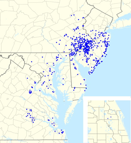
| dabartinis | 22:57, 31 liepos 2012 | | 644 × 704 (138 KiB) | Magog the Ogre (aptarimas | indėlis) | == {{int:filedesc}} == {{Information |Description={{en|1=Footprint of en:Wawa Inc. as of {{ISOdate|2011-06-25}}.}} |Source={{Derived from|USA_Pennsylvania_location_map.svg|USA_New_Jersey_location_map.svg|USA_Maryland_location_map.svg|USA_New_York... |
Jūs negalite perrašyti šios rinkmenos.
Rinkmenos naudojimas
Šie puslapiai naudoja šią rinkmeną: