File:Western Polynesia and Polynesian Outliers - fr.svg

원본 파일 (SVG 파일, 실제 크기 1,238 × 939 픽셀, 파일 크기: 4.02 MB)
캡션
설명
파일 설명
[편집]
| 설명 |
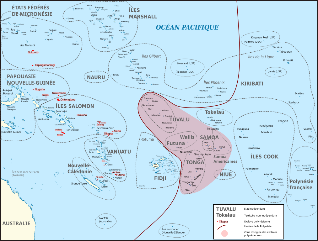
Français : Carte du Pacifique montrant la Polynésie occidentale et les différentes exclaves polynésiennes (en rouge). La zone en rouge clair correspond à la zone originelle de peuplement de Polynésie, d'où sont parties les populations qui habitent les exclaves polynésiennes. Les traits entourant les différents territoires ne sont pas les frontières maritimes actuelles, simplement un repère.
Carte d’origine : File:BLANK in Oceania (small islands magnified) (-mini map -rivers).svg Sources pour les noms des îles : Fidji : File:FijiOMCmap.png Nouvelle-Calédonie et Vanuatu :
Îles Salomon :
Tonga: FIle:Tonga.jpg Micronésie : File:Micronesia,_administrative_divisions_with_island_names_-_colored_-_fr.svg Îles Marshall: Kiribati :
Polynésie française : File:French_Polynesia_relief_map.svg Liste des exclaves polynésiennes : https://fr.wikipedia.org/wiki/Exclaves_polyn%C3%A9siennes
English: Map of Oceania showing Polynesian outliers. The red zone is the original Polynesian homeland, from where Polynesian seafarers went to the various Polynesian outliers. The lines around countries and territories are not the actual maritime borders.
Sources for this map : Original map : File:BLANK in Oceania (small islands magnified) (-mini map -rivers).svg Island names : Fidji : File:FijiOMCmap.png New Caledonia and Vanuatu
Solomon Islands :
Tonga: FIle:Tonga.jpg Micronesia: File:Micronesia,_administrative_divisions_with_island_names_-_colored_-_fr.svg Marshall islands: Kiribati :
French Polynesia : File:French_Polynesia_relief_map.svg List of Polynesian Outliers : https://fr.wikipedia.org/wiki/Exclaves_polyn%C3%A9siennes |
| 날짜 | |
| 출처 | 자작 |
| 저자 | Skimel |
_(-mini_map_-rivers).svg)
.png)
라이선스
[편집]
- 이용자는 다음의 권리를 갖습니다:
- 공유 및 이용 – 저작물의 복제, 배포, 전시, 공연 및 공중송신
- 재창작 – 저작물의 개작, 수정, 2차적저작물 창작
- 다음과 같은 조건을 따라야 합니다:
- 저작자표시 – 적절한 저작자 표시를 제공하고, 라이센스에 대한 링크를 제공하고, 변경사항이 있는지를 표시해야 합니다. 당신은 합리적인 방식으로 표시할 수 있지만, 어떤 방식으로든 사용권 허가자가 당신 또는 당신의 사용을 지지하는 방식으로 표시할 수 없습니다.
- 동일조건변경허락 – 만약 당신이 이 저작물을 리믹스 또는 변형하거나 이 저작물을 기반으로 제작하는 경우, 당신은 당신의 기여물을 원저작물과 동일하거나 호환 가능한 라이선스에 따라 배포하여야 합니다.
파일 역사
날짜/시간 링크를 클릭하면 해당 시간의 파일을 볼 수 있습니다.
| 날짜/시간 | 섬네일 | 크기 | 사용자 | 설명 | |
|---|---|---|---|---|---|
| 현재 | 2016년 11월 12일 (토) 13:44 | | 1,238 × 939 (4.02 MB) | Skimel (토론 | 기여) | Changed the fonts to DejaVu Sans condensed, resized the map, changed the shape of some country borders to fit the text better. |
| 2016년 11월 12일 (토) 11:50 |  | 2,476 × 1,885 (3.99 MB) | Skimel (토론 | 기여) | Fixed the black box in the upper left corner, resized the map so that one can zoom in more (but apparently caused other black rectangles...) | |
| 2016년 11월 11일 (금) 13:22 |  | 617 × 466 (3.98 MB) | Skimel (토론 | 기여) | User created page with UploadWizard |
이 파일을 덮어쓸 수 없습니다.
이 파일을 사용하는 문서
다음 문서 1개가 이 파일을 사용하고 있습니다:
이 파일을 사용하고 있는 모든 위키의 문서 목록
다음 위키에서 이 파일을 사용하고 있습니다:
- ca.wikipedia.org에서 이 파일을 사용하고 있는 문서 목록
- en.wikipedia.org에서 이 파일을 사용하고 있는 문서 목록
- es.wikipedia.org에서 이 파일을 사용하고 있는 문서 목록
- fr.wikipedia.org에서 이 파일을 사용하고 있는 문서 목록
- it.wikipedia.org에서 이 파일을 사용하고 있는 문서 목록
- ja.wikipedia.org에서 이 파일을 사용하고 있는 문서 목록
- ko.wikipedia.org에서 이 파일을 사용하고 있는 문서 목록
- pt.wikipedia.org에서 이 파일을 사용하고 있는 문서 목록