File:William Francis Lynch, Sketch map of the Dead Sea (FL25570575 3468188).jpg
קפיצה לניווט
קפיצה לחיפוש

גודל התצוגה המקדימה הזאת: 338 × 600 פיקסלים. רזולוציות אחרות: 135 × 240 פיקסלים | 270 × 480 פיקסלים | 432 × 768 פיקסלים | 577 × 1,024 פיקסלים | 1,154 × 2,048 פיקסלים | 5,688 × 10,096 פיקסלים.
לקובץ המקורי (5,688 × 10,096 פיקסלים, גודל הקובץ: 81.74 מ"ב, סוג MIME: image/jpeg)
כיתובים
כיתובים
נא להוסיף משפט שמסביר מה הקובץ מייצג
תקציר
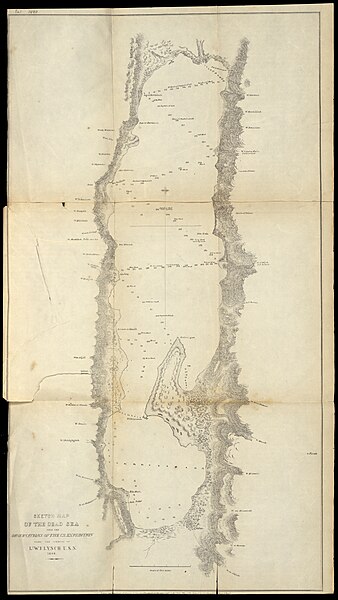
[עריכה]| ויליאם פרנסיס לינץ': Sketch map of the Dead Sea
( |
||||||||||||||||||||||||
|---|---|---|---|---|---|---|---|---|---|---|---|---|---|---|---|---|---|---|---|---|---|---|---|---|
| אומן |
|
|||||||||||||||||||||||
| כותרת |
Sketch map of the Dead Sea |
|||||||||||||||||||||||
| מפרסם |
Lea and Blanchard |
|||||||||||||||||||||||
| תיאור |
Sketch map of the Dead Sea. from the observations of the U.S. expedition under the command of Lt. F.Lynch U.S.N. 1848.. |
|||||||||||||||||||||||
| שפה | אנגלית | |||||||||||||||||||||||
| תאריך הוצאה לאור | 1849 | |||||||||||||||||||||||
| טכניקה | 1 sheet ; | |||||||||||||||||||||||
| ממדים | גובה: 63 ס"מ; רוחב: 35 ס"מ | |||||||||||||||||||||||
| אוסף |
|
|||||||||||||||||||||||
| מיקום נוכחי |
|
|||||||||||||||||||||||
| מיקום הוצאה | פילדלפיה | |||||||||||||||||||||||
| חיפוש בקטלוג מרחב | פילדלפיה | |||||||||||||||||||||||
| הערות | From: Narrative of the United States' expedition to the river Jordan and the Dead Sea. Philadelphia, Lea and Blanchard, 1849, between pp.268-269. | |||||||||||||||||||||||
| IE PID | IE25570573 | |||||||||||||||||||||||
| רוזטה שם קובץ | FL25570575 | |||||||||||||||||||||||
| מזהה רשומה בספרייה הלאומית (P3959) | 990034681880205171 | |||||||||||||||||||||||
| חיפוש בקטלוג מרחב | אנגלית, ויליאם פרנסיס לינץ' | |||||||||||||||||||||||
| חיפוש בקטלוג מרחב | Lea and Blanchard | |||||||||||||||||||||||
| מקור/צלם |
|
|||||||||||||||||||||||
| גרסאות אחרות | ||||||||||||||||||||||||
| Jpg / Tif version |
|
|||||||||||||||||||||||


.jpg)

.jpg&action=edit§ion=1)
רישיון
[עריכה].jpg&action=edit§ion=2)
The copyright situation of this work is theoretically uncertain, because in the country of origin copyright lasts 70 years after the death of the author, and the date of the author's death is unknown. However, the date of creation of the work was over 120 years ago, and it is thus a reasonable assumption that the copyright has expired (see here for the community discussion). Do not use this template if the date of death of the author is known.
| |
| הקובץ הזה זוהה כקובץ חופשי מכל מגבלה ידועה תחת חוק זכויות היוצרים, כולל כל הזכויות הקשורות והסמוכות. | |
היסטוריית הקובץ
ניתן ללחוץ על תאריך/שעה כדי לראות את הקובץ כפי שנראה באותו זמן.
| תאריך/שעה | תמונה ממוזערת | ממדים | משתמש | הערה | |
|---|---|---|---|---|---|
| נוכחית | 14:23, 16 באוגוסט 2023 | | 10,096 × 5,688 (81.74 מ"ב) | Geagea (שיחה | תרומות) | pattypan 22.03 |
אין באפשרותך לדרוס את הקובץ הזה.
שימוש בקובץ
הדף הבא משתמש בקובץ הזה:
.jpg&oldid=808415498)